Facilitating marine debris detection with advanced ocean forecasts
 Written by
Sharmain Zain
Content Manager at Spire Weather
Could there be more plastic in the sea than fish by the year 2050?
As per a report issued by the Ellen MacArthur Foundation, it’s a definite possibility. Right now, the oceans are filled with 165 million tons of plastic already. Let’s visualize this: picture the Great Pyramid of Giza in your mind. Hold it steady. Now, make it 25 times bigger and that’s the equivalent quantity of plastic plaguing floating in the high seas.
What’s causing this, you may wonder? It’s us. You. me. All of society. In the last fifty years, the consumption of plastic has increased by more than twenty times and is only rising further. Given that only 14% of actual plastic is recycled, that still leaves the majority being chunked as garbage.
Why is it essential to track marine debris?
All this accumulated debris swimming is harming marine wildlife. To put this into context, it’s estimated that fish consume an estimated 12000-14000 tons of plastic annually that’s causing intestinal injury and death. In the end, it’s a vicious food chain as it comes back to us only. A study from the University of California, Davis discovered that more than 25% of fish sold at markets contained plastic debris in their guts.
It’s not just fish that is being impacted by the plastic pollution crisis- seabirds are susceptible to this danger as well. As they eat plastic, it takes up storage space in their stomachs and causes them to starve. By 2050, it’s predicted that 99% of all seabirds will have consumed pieces of plastic as compared to the current 60%. Sea turtles consider floating pieces of plastic to be food and eat it. This causes them to either choke, suffer internal injuries or die from starvation. Marine mammals are not safe from this either.
With over 267 species affected globally, that spans 44% of seabirds, 43% of all marine mammals and 86% of seabird species, it’s imperative that marine debris be tracked so as to understand the impact on sea life. The Japanese coast witnessed a ten fold increase in the volume of pelagic plastic particles between the 1970-80s. This is also the time when international production of plastic fibers shot up by four times. Autopsies conducted on the body of a washed up California gray whale on the shores of the Puget Sound revealed more than 20 plastic bags, a golf ball, surgical gloves and even a pair of pants.
This is why like-minded space enterprises such as Amanogi Space and Spire Global are coming together to address this very challenge: tracking marine debris along the Japanese coast (to start with).
Harnessing the power of space technology
Amanogi Space, a leading Japanese entity, is developing solutions for the collection and analysis of satellite imagery by using methodologies such as machine learning and artificial intelligence to detect marine debris and hope to help clean up our oceans.
Spire Global, as you may know, has the largest constellation of nanosatellites in close orbit to Earth that collects atmospheric data 24/7 for all points across the globe. Partnering with Spire, Amanogi has utilized Spire’s historical weather data to train its simulation algorithm so as to improve its accuracy level in forecasting the flow of marine debris.
Challenge
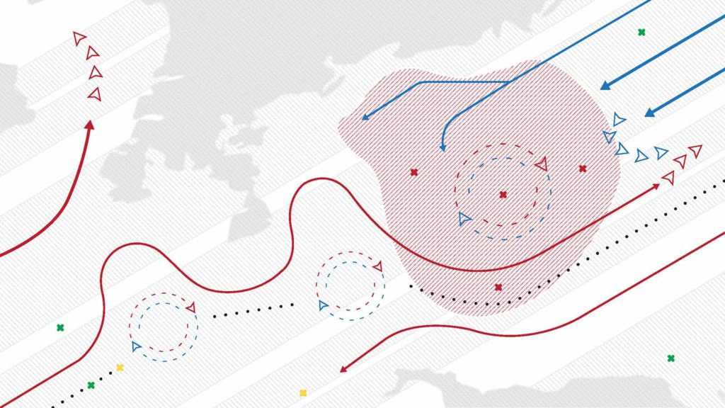
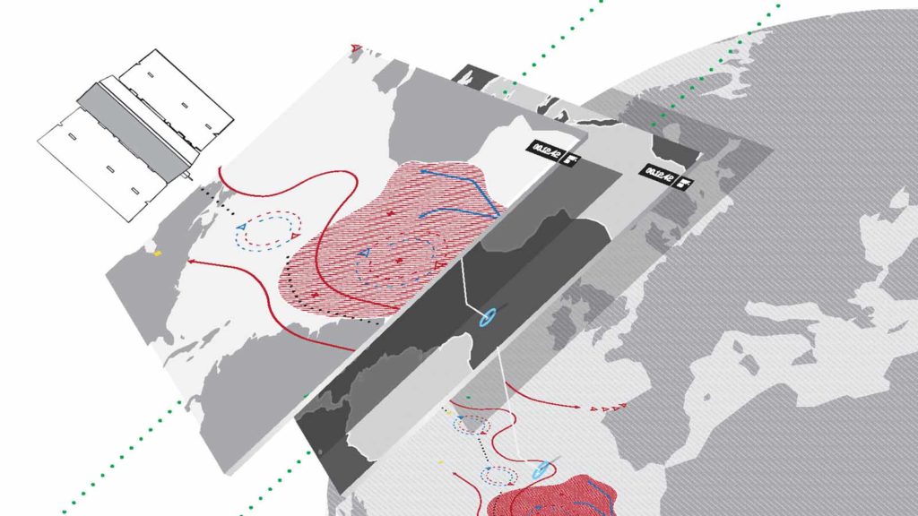
Amanogi Space aims to identify a statistical correlation between the movement of marine debris against the ocean currents around the Japanese coastline. To achieve this, Amanogi Space required historical weather data to simulate local debris advection to compare against global models generated from satellite-based imagery.
“Spire Weather’s historical weather data will be critical in our model studies and to fight the global plastic pollution crisis. It will not only train our AI-based algorithms and increase their accuracy but it will also provide granular, consistent datasets that are specific to our use case.”
Share on Facebook Share on Twitter Share on LinkedIn
Solution
Spire’s comprehensive historical weather datasets powered Amanogi’s predictive analytics to understand how ocean currents influence the direction of debris.
To test its hypothesis, Amanogi Space will incorporate Spire’s historical weather data to train its AI model so as to enhance its capability to analyze and predict debris advection.
Testing Methodology
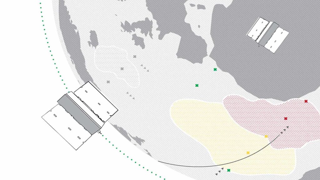
1. Debris detection from satellite imagery
Amanogi Space predicted marine debris on the coastal regions of Masuda using satellite imagery via machine learning algorithms.
2. Simulation of debris advection from Spire Maritime Weather data
As ocean currents affect debris accumulation, Amanogi simulates the path of debris advection from Spire’s historical weather data.
3. Reference check and robust debris prediction
The debris prediction from the satellite imagery will be compared against the simulated result to identify, if any, co-relationships and statistical patterns.
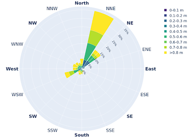
Spire Weather wave height data: the validation benchmark
Amanogi is aiming to use wave height data for interpreting the global ocean current situation. They are currently in the process of analyzing other datasets to validate this theory.
Ocean significant wave height distribution chart
Preliminary Results
Amanogi Space is developing the technology to detect the coastlines that are contaminated by debris via satellite imagery. Having achieved 87% accuracy levels in their prediction models, Amanogi Space (as shown in the images below where the red dots signify the debris-filled areas) hopes to utilize Spire’s historical weather data to train their algorithm to attain higher quality results in terms of accuracy and granularity.
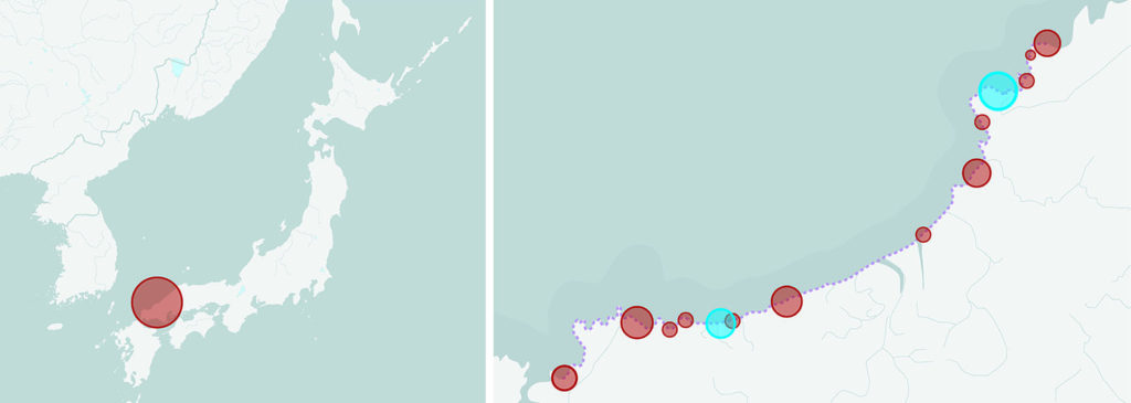
The red represents debris that was detected whilst the blue represents the undetected portion of the debris.
The way forward
Amanogi will be using Spire Weather Data to continually train their marine debris algorithm and improve its accuracy in forecasting the direction that debris will flow. The end vision here is to discover the correlation between debris advection and ocean currents. Once this is identified, Amanogi will further train its AI-powered models with satellite images. Amanogi hopes to take this on to a global scale and help countries predict where marine debris may wash up so they can take action beforehand and optimize costs accordingly.