How Enhanced Satellite AIS provides situational awareness of possible sanction violations
How Geollect use Enhanced Satellite AIS to provide an accurate picture of the marine environment, including possible sanction violations.
![]()
Enhanced Satellite AIS and Geospatial Intelligence
Geollect provides cross-domain geospatial intelligence to provide safety, security, and operational understanding.
Challenge
Geollect’s core challenge is providing actionable insights from broad, disparate, and inconsistent data sets.
Geollect developed Geonius™, a dedicated geospatial intelligence platform that contextualizes and processes data, and visualizes it on easy to use interactive maps. Geollect needed to find the most complete data to reduce the margin of error in alerts for AIS outages caused by gaps in T-AIS and S-AIS signal. They also wanted to increase the overall level of confidence in alerts for indicators of possible non-sanction compliance.
An image from Geollect’s Geonius™ platform
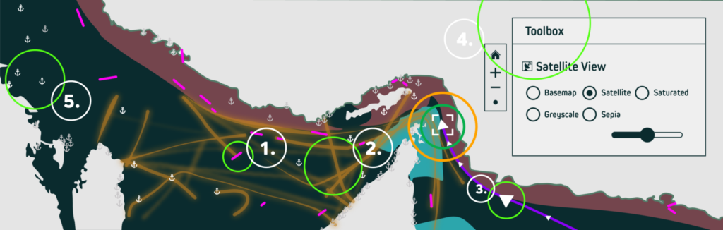
1. Example of a vessel that has triggered an alert. 2. International shipping lanes, created by Geollect using Spire AIS data. 3. AIS data points showing 7-day journey of selected vessel. 4. Investigate tools to explore where vessel could have travelled during AIS outage. 5. World ports and anchorages database
Solution
For this tool to be effective for their customers, they needed global, complete AIS data. Geollect upgraded to Spire’s Enhanced Satellite AIS to provide an accurate picture of the marine environment.
This unique combination of three AIS sources including Enhanced Satellite AIS, provides comprehensive situational awareness of possible sanction violations and enables detailed investigations. This helps insurers comply with legislation and identify non-desired behaviour by insured vessels.
“Since the addition of Spire’s Enhanced Satellite AIS to Geonius™, we reduced the number of alerting vessels by up to 84% which reduces work on the part of loss prevention investigators, and increases confidence in our system.”
Dr. Ryan Lloyd
Head of Research & Development, Geollect
Share on Facebook Share on Twitter Share on LinkedIn
Results
The comprehensive volume of AIS data, combined with an intuitive user experience, saves time and effort and provides actionable insights.
The completeness of Enhanced Satellite AIS data is essential to navigating the complex and fluid nature of sanction compliance.
The platform is enriched with a wide range of other data sources including intelligence reports, geospatial data, proprietary data sets, weather, and geopolitical events. As the requirements of users evolves, additional Spire data is added to further enhance fleet tracking and alerting capabilities.
Normalised daily number of alerting vessels pre and post the addition of Enhanced Satellite AIS data

The inclusion of Enhanced Satellite AIS dramatically increases the completeness of AIS data, reducing the amount of vessel alerts sent via Geollect’s Geonius™ system for non-transmission of AIS in the key regions above by up to 84%.