Satellite AIS Tracking: Everything you need to know
- Intro
- What does AIS mean?
- What is AIS for?
- How does AIS work?
- What does an AIS message contain?
- What types of AIS devices exist?
- What are the safety benefits of AIS?
- What is the limit of the AIS system?
- How to go beyond the 50-mile barrier?
- Getting the big picture with S-AIS
- Types of S-AIS detection
- Why Spire Maritime's S-AIS?
- What are the use cases of S-AIS?
Learn more about how Satellite AIS goes beyond typical AIS, and how it enables a variety of maritime use cases.
Here’s a fact that you just can’t water down: About 70 percent of the world’s surface is ocean. People rely on these oceans — big time — because 90 percent of today’s global trade takes place on the ocean. Industry, governments, maritime authorities, and businesses need to have a comprehensive picture of what’s going on at sea in order to protect people.
Technology exists to address this critical need to have a complete global maritime picture. The Automatic Identification System (AIS) is an established technology for tracking maritime activity, but it’s not without its visibility limitations; it can see only so far from the coast. That’s why Satellite AIS (S-AIS) is becoming more popular — the maritime community is literally seeing reliable vessel monitoring that goes far beyond what was once thought possible.
And with more advances in satellite constellations and ground stations, the amount and quality of data that can be collected from space is increasing. Thanks to these advancements, S-AIS not only gives a complete global view of the entire world’s shipping but also is the only technology that tells the complete story of maritime activity. S-AIS enables the timely and accurate monitoring of ships across the globe.
Looking for AIS data?
Spire Maritime is a leading AIS data provider, with solutions ranging from live AIS feeds, to historical data, vessel to port ETA and AIS Position Validation. Learn more about our full range of solutions:
What does the acronym AIS mean?
The AIS acronym means Automatic Identification System, an essential part of maritime safety. The familiar idea of two ships that pass in the night is a little sad in the poetic sense, but in reality, that’s exactly what ships should do. AIS was designed to prevent ships at sea from colliding, by allowing them to know the locations of nearby ships.
What is AIS? Learn more about it in our AIS Fundamentals article.
What is AIS for?
A vessel’s personnel use AIS to ensure the safety of the ship, and maritime authorities use AIS to track ships and monitor where they are and where they are going.
AIS is a communications system based on radio frequency (RF), which is a form of wireless communications that uses the transmission and reception (sending and receiving) of electromagnetic waves. These waves work very much the same as do wireless transmissions from and to cellular telephones.
A ship’s AIS transponder (the device that sends and receives signals) uses a very high frequency (VHF) RF transmitter to broadcast important information to receiver devices on other ships or land-based systems. By sending and receiving regular communications about their identity and course, vessels can avoid collision and navigate safely, even when they can’t see each other.
Today, AIS transponders are so prevalent that the data they transmit and receive has become increasingly valuable, and not just to the vessels themselves. Naval forces, port authorities, coast guards, and other marine authorities use AIS data to improve their awareness of the current maritime situation.
What is the legal framework behind AIS?
Since 2004, the International Maritime Organization (IMO) has required AIS transponders to be aboard most vessels. The Safety of Life at Sea (SOLAS) Convention, Chapter V, states: “All ships of 300 gross tonnage and upwards engaged on international voyages and cargo ships of 500 gross tonnage and upwards not engaged on international voyages and passenger ships irrespective of size shall be fitted with an automatic identification system (AIS).”
More than 60,000 ships worldwide have installed these transponders at a combined cost of several hundred million dollars, making AIS one of the most successful maritime technology deployments of all time. Equipment that uses AIS technology is increasingly being deployed in smaller vessels, as well as radio/AIS-enabled aids to navigation (AtoNs), and it is also being installed on search and rescue (SAR) vessels and aircraft.
How does AIS work?
Even though you can’t see the signals, AIS isn’t magic; it’s advanced, interesting, and sophisticated (get it?) technology that is used all over the world. This section discusses how AIS devices share information with other ships and land-based systems. You also find out about the strategy AIS uses to organize all of these signals and get the timing just right.
How is AIS information broadcasted?
AIS devices send out information about the ship automatically and regularly, typically every few seconds.
AIS transponders on nearby ships or on land (for example, a vessel traffic services system) receive these signals. The information is displayed either on radar or on a chart plotter, showing ships’ positions and call sign information.
When other ships and maritime traffic services know these key details, they can use them to ensure ships are following a safe course and to prevent collisions. So ship personnel don’t need to physically see where other vessels are located in order to avoid them.
AIS combines technologies. It integrates a standardized VHF transponder with a positioning system, such as a long-range navigation system or global positioning system (GPS) receiver, with other electronic navigation sensors, such as a gyrocompass or rate-of-turn indicator.
Using time slots
The preceding section mentions how AIS communications happen regularly and automatically. Here, you can find out more about how that works.
TDMA
AIS communications are based on a time division multiple access (TDMA) system, which permits each device to communicate during a given time period, or time slot. So the signals aren’t being transmitted continuously, but only during their own time slots.
TDMA is the original communications system that cellular telephones used to use, except that cell phones had continuous communication with the cell tower — imagine trying to have a conversation if they hadn’t! But ships aren’t always within range of a tower, so TDMA was not the complete answer.
Each ship must have its own time slots to broadcast within. If they don’t, ships within close range of each other would constantly be competing for the same time slots when sending their position reports, and the AIS messages would be lost because of the resulting interference.
SOTDMA
Self-organizing TDMA (or SOTDMA) is the system that ensures AIS communications happen in an orderly way. It’s like making sure you make a reservation before going out to the best restaurant so that you don’t end up hungry.
Before an AIS transmitter is able to transmit, it first listens to the AIS frequencies to build a picture (a time slot map) that indicates the slot locations of other nearby AIS transmitters. With this information, an AIS transmitter knows that when it does transmit, it won’t interfere with another AIS transmitter.
Furthermore, with SOTDMA, the AIS device has to announce ahead of time which time slots it will use, and it can’t use the slots that have been reserved by another device. Think first come, first served — SOTDMA plays fair.
So by listening first, the AIS transmitter knows where other transmitters are and which slots they’re reserving next. To make this fair, the slot selection is random, and each selection has a random timeout (the length of time the AIS transmitter will be permitted to continue to use the time slot).
In this way, every device that receives the “preannouncement” notes that those time slots have been taken, and then knows to choose different time slots to transmit its signals. SOTDMA is a very polite technology indeed! This system allows the AIS devices to organize transmissions around each other in both an efficient and a non-interfering basis. Again, thinking back to cellular wireless communications, the limited range of these AIS signals over the ocean creates a cluster, or cell, of ships with AIS transmitters within communications range (so all ships can hear and be heard by other vessels). Within such a cell, these organized prearranged time slots and timeouts create an AIS communications cell. Figure 1-1 illustrates a communications cell made up of time slots. Depending on the ship’s speed and where it is going, the SOTDMA protocol will adjust the number of reporting time slots required, making time slots from as little as two seconds for fast-moving ships to up to three minutes when at anchor.
As vessels move, they may need to change their time slot assignments. So when an AIS device changes its time slot, it preannounces both the new time and the timeout for that location. Quite clever!
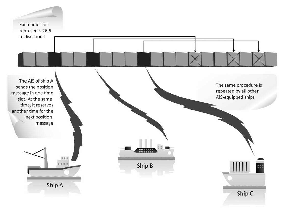
A communications cell is made up of time slots
What happens when slots collide?
The term maritime traffic is used for a good reason: Because so many vessels are coming and going, things can get really busy on the ocean (imagine your morning commute without the traffic lights and paved roads!). And just like on a busy highway, with so many vessels passing in and out of AIS communications cells, the possibility of slot collision (more than one AIS device attempting to use the same time slot) does exist.
But just because slots collide, it doesn’t mean that vessels will. Slot collision doesn’t affect the AIS’s main goal of keeping ships safe. The ship that is closest will always have a stronger signal, ensuring that the more important AIS message, from the closer ship, will be received correctly.
But what slot collision can affect are the stations that may be able to receive signals from more than one AIS communication cell simultaneously, such as AIS base stations along coastlines and receivers on satellites. When an AIS station does receive AIS messages from different AIS transmitters that overlap in a single time slot, a collision will corrupt both originating messages at the receiver. From space, where many hundreds of such AIS communication cells can be heard, the likelihood of message collisions increases very rapidly. Without some form of decollision technology, the resulting AIS receiver can quickly become overwhelmed with colliding AIS messages.
What does an AIS message contain?
AIS messages contain a whole lot of information about a vessel, including details such as the following:
- Course
- Position
- Rate of turn
- Speed
And in some cases, AIS messages may also send other information:
- Destination
- Estimated time of arrival (ETA)
- Ship name
- Type of vessel
What types of AIS devices exist?
Several types of AIS devices exist, and they all interact with each other using AIS protocols and international performance standards. Having standards and protocols is important to make sure that all these devices are “speaking the same language” and able to communicate with each other.
This section tells you about some types of AIS devices and what they must be able to do.
The class of AIS device required to be carried on a particular vessel depends on the mandate the vessel falls under. For example, all vessels that fall under the International Maritime Organization’s mandate must carry Class A devices. Individual countries tend to require a mix of Class A and Class B devices, depending on the function and size of the vessel. Vessels that voluntarily carry AIS can carry any class of device, but they tend to carry Class B most often.
Class A devices
Class A devices are found on board vessels, and they are transceivers (meaning they pull double duty and can transmit and receive signals) that operate using SOTDMA.
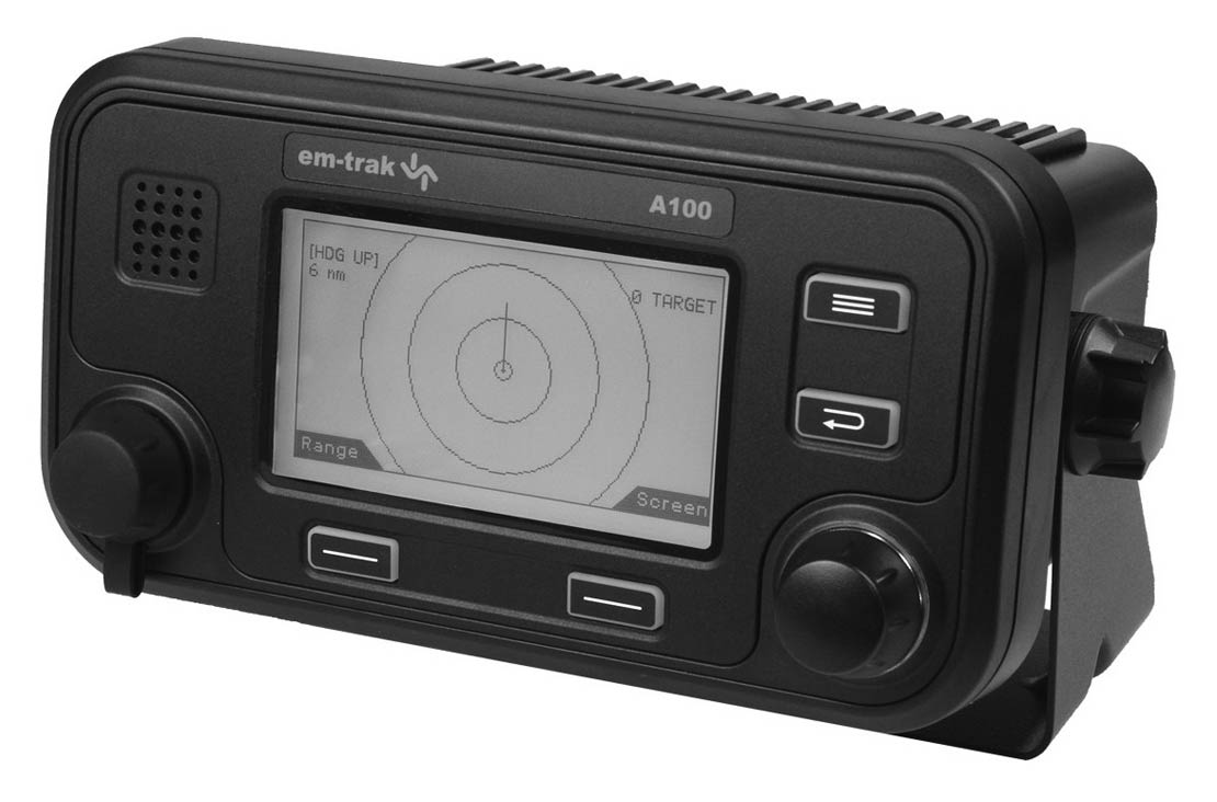
Example of a class A AIS device
Class A devices must do the following:
- Work with the ship’s radar and display systems
- Have an integrated display
- Transmit at 12.5 watts
- Be able to work with many of the ship’s systems
- Offer advanced features and functions
Class B SO devices
Class B SO devices (as in, it’s great to be so curious about AIS!) are also located on board ships and are transceivers using SOTDMA. Here is an example of what they look like and how they’re a bit different from Class A devices:
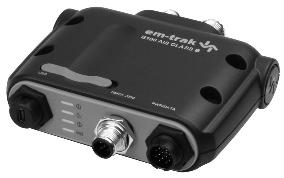
Example of a class B device
Class B devices must do the following:
- Work with the ship’s radar and display systems
- Have an integrated display
- Transmit at 5 watts
- Be able to work with many of the ship’s systems
- Offer advanced features and functions
Class B CS devices
Class B CS devices are located on board ships and are transceivers, but they work using carrier-sense TDMA (CSTDMA), which is restricted to a single time slot for transmissions.
Here are the other features of Class B CS:
- Are not required to have an integrated display, but must be able to connect to most display systems
- Transmit at 2 watts
- Have a default transmit rate of every 30 seconds (but this may vary according to the ship’s speed or special instructions from base stations)
- Have integrated GPS
- Be able to receive all types of AIS messages
AIS SART
A search and rescue transponder (SART) is a device that likes to play the hero. A SART uses AIS technology to find vessels in distress. It intermittently sends a position report and safety text message; however, it does not have a receiver. SARTs don’t give up easily, and they continue to send signals for 96 hours after they’ve been deployed. They transmit at 1 watt.
AIS aids to navigation
Aids to navigation (AtoN) are markers that help ships travel successfully, such as buoys. AtoN can be used by an AIS station to display its location on charting and radar systems. A station can then also transmit important information about weather and sea conditions to help vessels navigate safely.
AIS AtoN devices can transmit at 1 to 12.5 watts, with transmission intervals of between one and three minutes. Two kinds of AIS AtoN devices exist: those that receive signals only through reserved time slots, and those that can send and receive through SOTDMA.
AIS base stations
AIS base stations are fixed (non-mobile) stations that maritime authorities use to monitor and control vessel traffic. These base stations can also control other AIS devices, and have the following capabilities:
- Turn other AIS devices on or off
- Reserve time slots for special transmissions
- Control which time slots mobile AIS devices use
- Control the power level of mobile AIS devices
Though AIS transponders use “self-organized” time slots using SOTDMA, the base station is able to further impose even more efficient SOTDMA organization within its vicinity, ensuring communications in busy harbor areas.
Port authorities and coast guards have a real interest in knowing about ship movements, so it’s not just the vessels that have gone into the AIS game. Many coastal AIS stations are being built to improve safety and security for a country’s shoreline. These systems are expensive to build and maintain, but they allow authorities to monitor vast areas of shoreline that, prior to AIS, needed far more costly systems to monitor.
In general, coastal AIS has a range of about 50 nautical miles (see the end of this part for more about this), but the coverage area can be shorter, depending on a few factors:
- Site of installation
- Height of the antenna
- Volume of traffic in the area (which could lead to slot collision)
What are the Safety Benefits of AIS Technology?
If you’re a safety-first kind of person, you may have flipped directly to this section. If you read through the rest of this part, you already know the main purpose of AIS is to prevent vessel collisions. But this technology also includes a host of other safety benefits:
- X-ray vision: Well, sort of. Ships know the locations of all surrounding vessels, even when they can’t actually see each other. That’s because, unlike radar, AIS signals can actually “see” behind islands or around river bends by simply repeating the signal. So no ship can play a game of hide-and-seek; even when a vessel seems to be invisible, AIS can detect it and know where it is, which makes navigation safer and prevents collisions.
- Guide the way: Aids to navigation (AtoN) devices transmit AIS signals. This includes even physical aids such as buoys. (You can find out a bit more about AtoN in Part 4.)
- Signals from ship or shore: Either on-ship or shorebased stations can issue safety messages. So a ship that is adrift can broadcast an “adrift with no engine” warning, stations can issue storm warnings to vessels, and ships can issue search and rescue information for emergency assistance.
- Neither rain nor sleet: AIS signals can be sent and received even in very poor conditions, such as in nighttime heavy rain, in fog, or during snow squalls.
What is the limit of the AIS system?
AIS is a widely used maritime technology that has become important to maritime authorities around the world. But it’s precisely the part about a round Earth that presents limitations for this system.
The 50-mile barrier
Some say that the sky’s the limit, but in this case, it’s actually the horizon. Because the Earth is round, AIS doesn’t have unlimited range. Its signal transmission is limited to approximately 50 nautical miles. Imagine watching a ship sail off into the sunset on the horizon. If you keep watching (and if you have super-powered glasses that give you exceptional vision), eventually the ship will seem to disappear as it follows the curvature of the Earth.
This range limitation can prevent maritime authorities from getting a complete picture of maritime traffic outside of their borders and on a bigger scale. The answer to this is Satellite AIS.
What is Satellite AIS?
Satellite AIS (S-AIS) is a technology for tracking maritime activity using AIS and satellites, greatly extending the range of traditional AIS, as signals are sent and received from many kilometers above land and sea, so the barrier of the horizon doesn’t limit these signals.
Extended range of S-AIS signals
With AIS, devices need to be fairly close together to communicate. But S-AIS removes these barriers, and authorities get a much more complete picture of maritime activity in the areas in which they’re specifically interested. This provides many benefits, including the following:
- Improved ability to identify potential threats
- Better monitoring of vessel traffic patterns
- More cost-effective use of assets
A bonus to getting the bigger picture is that S-AIS can be implemented without additional hardware upgrades — vessels and stations are already outfitted with AIS technology.
Getting the Big Picture with S-AIS
An increased need exists to get the complete picture of what’s happening in authorities’ territorial waters, including areas that are distant and isolated from ports and shorelines.
Think of trying to put together a jigsaw puzzle with crucial pieces missing. It’s frustrating, and you don’t end up with the whole picture. That’s kind of what it’s like when maritime authorities attempt to get a complete picture of activity on the water without using S-AIS — without satellites, they’re always missing pieces of the puzzle!
The initial idea for AIS was to prevent collisions between ships. Using AIS technology, vessels within close proximity of each other send signals to form a communication cell, and each ship has its own time slot to prevent messages from getting mixed up, or colliding.
A satellite can detect many of these communication cells at the same time. It can capture thousands of individual ships’ signals all at once. Spire Maritime’s technology uses groups of nanosatellites to provide a complete picture of ships’ activity in even the most remote areas of the world’s oceans. Satellites take all the mystery out of these little-explored regions.
What are the two types of Satellite AIS detection?
Detecting S-AIS signals can be done in two ways. This section looks at both of these methods for getting messages from space.
On-board processing
On-board processing (OBP) uses specialized receivers on satellites that work a lot like the standard AIS receivers on Earth, but they are more sensitive.
OBP doesn’t require special processing and works well in very low-density areas, such as the Pacific Ocean where there is little traffic.
However, OBP may not be as effective in detecting signals in areas that contain more than 1,000 ships, because of the slot collisions that high density can cause. This means OBP may not detect all messages during its first pass, or orbit, of an area, and may need to go over an area several times before it assembles a complete picture.
And if a given area has quite a heavy volume of ship traffic — more than 2,500 vessels — OBP will have an even harder time giving a full, accurate picture. That’s because with so many signals, slot collisions will occur, and OBP isn’t capable of resolving colliding messages.
The reason slot collisions occur is because the satellite is seeing multiple cells. Within a communications cell, an AIS device’s slot selection is randomized and tagged with a random timeout. When an AIS unit changes its slot assignment, it announces the new location and the new timeout. As vessels pass in and out of communications cells, the chance of slot collision grows. But because two channels for backup exist, and because the closer vessel is always heard first, slot collisions don’t affect the primary purpose of AIS — collision avoidance. However, slot collisions do affect receiver stations, which may hear multiple communication cells simultaneously; for example, signals from AIS base stations on land and from satellites.
Spectrum Decollision Processing
In spectrum decollision processing (SDP) the satellite listens and captures all AIS signals from across the AIS radio frequency spectrum. It then transmits all this information to Earth without trying to make sense of it. After the info is received on Earth, powerful computing is applied to sort out all the AIS messages from the noise of all the cells. It processes all of the information and decollides all the messages that were received simultaneously from vessels using specialized algorithms. This method allows for the most ships to be detected.
SDP works very well for areas with heavy maritime traffic, and it is important for detecting enough messages to get S-AIS working effectively.
The first time a satellite with SDP technology passes over a given area, it can get a nearly complete picture of what’s going on down on the water, even in high-density areas with thousands of ships. So you are able to get an accurate picture of maritime activity much more quickly.
Imagine you are James Bond on a mission. You are hiding out above a huge dining hall, spying on the diners below so you can get some top-secret intelligence. Hundreds of people are talking at once, and the noise of all these conversations is blending together.
If you, as James Bond, were working like an OBP satellite, you’d have to try to interpret every voice and conversation from the rest of the noise by listening, trying to identify who said what, writing everything down as fast as you could, and then sending your notes, which likely didn’t capture much, back to M at the Secret Intelligence Service. Using this method, you’d miss a lot of information.
But if you had a special listening device that worked just like an SDP satellite, you could sweep up all the noise and send it back to voice recognition systems, which would extract every individual conversation while you visited the casino to break some hearts.
Why Spire Maritime’s Satellite AIS?
Spire Maritime uses its own global satellite system and an advanced SAT-AIS detection technology, which has been developed to collect, process, distribute, and archive AIS messages received from ships all over the world. With Spire Maritime, you get the most accurate picture of maritime activity, no matter how many AIS messages are competing to be heard.
Tiny nanosatellites with huge benefits
Spire Maritime’s technology works by using a constellation (essentially a group) of nanosatellites that orbit the Earth. These satellites are always in motion, passing over different areas as the Earth rotates, and will complete an orbit in approximately 90 to 100 minutes.
While a traditional satellite is generally quite large, and weighs into the tons, a typical nanosatellite or cubesat weighs around 10 kilograms (22 pounds). They also have many advantages over their bulkier brothers:
- Cost: They can be designed, built, and launched for a fraction of the cost of traditional satellites.
- Time: They can be completed within a much shorter time frame.
- Technology: Because these smaller satellites cost less and are quicker to build, we can use leading-edge electronics or software that would be considered too risky to deploy on costlier, larger satellites.
Nanosatellites are ideal for wide-area surveillance, environmental monitoring, or remote-area tracking.
Collecting the data
The satellites’ job is to collect the AIS transmissions from every ship that is within the satellite’s field of view. These small satellites have a vantage point of about 650 kilometers (or about 404 miles) above the surface of the Earth, which is considered a low-earth orbit. But don’t let the word low mislead you — that’s low by satellite standards! Nanosatellites have an enormous field of view, approximately 5,000 kilometers (3,107 miles) in diameter.
Nanosatellites’ low orbit allows them to detect transmissions from lower-powered equipment that is at either ground or sea level.
Delivering the data
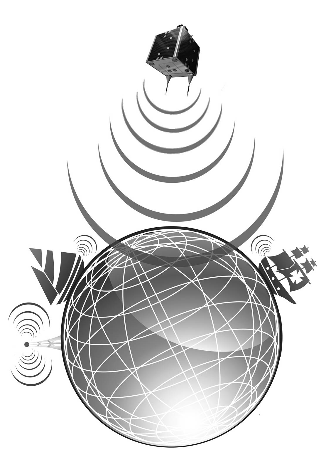
As a leader in global S-AIS vessel tracking, Spire Maritime collects more ship monitoring data than similar organizations and delivers the highest quality information to customers around the world. This information gives a better awareness of the maritime situation to governments and commercial organizations, whether they’re tracking a single vessel or monitoring vast areas of ocean.
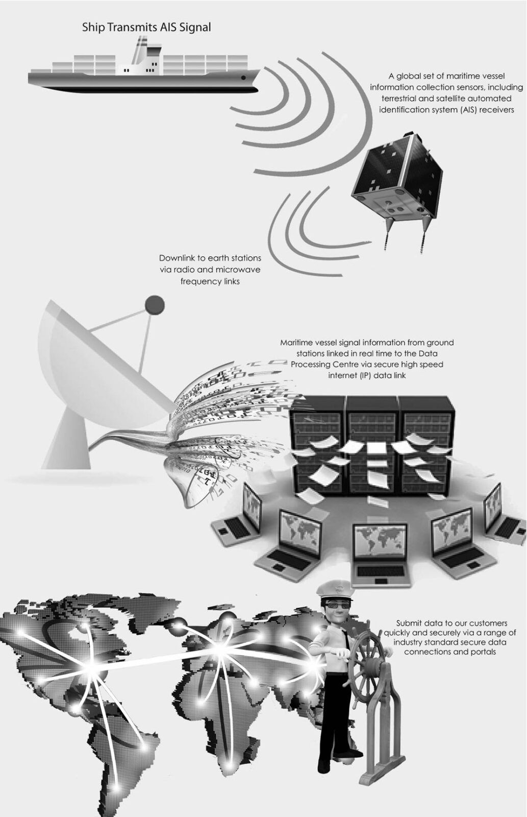
S-AIS signals travel from ship, to space, to ground to customer
Not all vessel tracking organizations provide a full range of services, but Spire Maritime does. We combine innovative technology with traditional customer service to deliver a global maritime picture. Here are the elements that make up the Spire Maritime technology platform:
- AIS transponders: These transponders are the source of the data for the Spire Maritime service. Because they’re already installed aboard hundreds of thousands vessels worldwide, no changes to existing onboard equipment or procedures are required, which saves time and money. Spire Maritime’s system can also detect signals from lower-power units, such as many search and rescue transponders (also called AIS-SART).
- Satellite payloads: These are receivers that are designed to detect AIS signals that sit aboard the satellites of the constellation. Think of these as the “ears” of the technology.
- Earth stations: (Also called ground stations, antennas, or dishes.) Earth Stations receive and/or transmit data to satellite platforms and can communicate with many different satellite types. Many ground stations receive data from the satellites as they pass overhead on every orbit, several times a day. After the data is downlinked (or the signals get sent from space to Earth), it is then sent, fully encrypted, to the Spire Maritime data processing center. More and more ground stations are being used around the world, and new stations are being developed for even faster data flow.
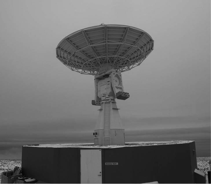
A ground station
As satellites orbit the Earth, they collect data and transmit that data when they are in sight of a compatible earth station. A satellite passes within sight of an earth station many times within an hour, so a lot of data must be downlinked in a very short time. The Spire Maritime satellites use a dedicated high-speed downlink channel for AIS data to ensure that all collected data is retrieved.
- Operations center: Equally important to collecting all the data is that the right information gets to customers when they need it. The operation center manages collecting S-AIS data from the satellites and then ensures data is configured and distributed to the appropriate data feeds across the globe. Satellites don’t sleep, and so the operations center is monitored 24/7!
- Data processing center: Security and reliability are also essential to getting the most out of S-AIS technology. When data is sent from a satellite to an earth station, it is transmitted to the data processing center.
- Customer delivery: Spire Mariitme data is delivered to competent maritime authorities over encrypted data links, in a variety of formats, including the standard National Maritime Electronics Association (NMEA), JavaScript Object Notation (JSON), and in CSV plain-text data format, depending on your delivery method of choice. Spire Maritime data is also available via GraphQL APIs and Open Geospatial Consortium (OGC)–compliant Geospatial Web Services.
If Spire Maritime data got a report card, the teacher would indicate that it plays well with others. It can easily integrate into different kinds of geospatial platforms and mapping systems. Also, customers can choose how to view their data. They can select a live interface that works with their existing display system, a web-based ship tracker app, or static data exports in the format of the customer’s choice.
Industry use cases for Satellite Automatic Identification System (S-AIS)
Satellite Automatic Identification System (S-AIS) technology is many things, but it doesn’t have a one-track — or rather, one-signal — mind. Sure, it can track ships and keep them safe, but this is only the tip of the iceberg. S-AIS can be used for a huge number of purposes, and this part explores the possibilities and the many applications for this technology.
Vessel tracking
Knowing where ships are and where they are going, even if it’s to the most remote places, has a host of benefits for maritime authorities and other organizations. Here, you find out about the ways Satellite AIS enhances vessel monitoring.
Safer ship routing
Maritime traffic isn’t quite as busy as on the expressway you drive to work, but it certainly is getting busier every year. Ships are under a lot of pressure to deliver their cargo on time, and they need safe and secure routes to do so.
S-AIS can monitor vessels globally, with a reach that is far greater than radar or coast-based AIS systems. It can automatically monitor a defined area or predetermined route, and warn maritime authorities if a vessel appears to be going off course. The S-AIS data about the ships can be combined with data about weather conditions or other conditions on the ocean, so maritime authorities can alert ships to change course and completely avoid dangerous areas.
Enabling VTMIS (Vessel Traffic Monitoring and Information Systems)
VTMIS enhance the safety and efficiency of maritime traffic, because they allow authorities to respond to incidents, accidents, or dangerous situations much more quickly.
Seeing the big picture of maritime traffic means authorities can oversee all vessels more closely. S-AIS gives this big picture. This way, authorities can make sure ships are following maritime regulations, recommendations, and safe practices. They can also use system data to know if vessels are heading into bad weather and warn them.
Ship reporting
Many countries have mandatory or voluntary ship reporting systems, which give critical information for traffic monitoring, search and rescue, environmental protection, and customs and immigration. The problem is that the reports may not always be correct or complete, because some ships don’t take the time to do the required manual reporting.
But all reporting with S-AIS is done automatically, so there’s no need for manual reporting. This means the data is complete and correct with each report.
Remote region monitoring
Monitoring remote region shipping in areas like the Arctic or coastlines of Africa is often a challenge, because the coastline is rather uninhabited with little or no industrial development. Infrastructure and systems are simply not in place in these regions as they are elsewhere in the world.
S-AIS is ideally suited to monitor such remote regions and provides a unique insight into shipping activities that take place there.
Using satellites, authorities can get a comprehensive view of Arctic maritime traffic trends, which they can use to design the safest and most effective shipping routes.
Validation of ship declarations
When vessels pass in and out of different waters, they can carry and transfer harmful aquatic organisms. In addition to harming the water, around 870 million tons of sulphur and nitrogen oxides, ozone-depleting substances, and volatile organic compounds get into the air through ships’ emissions. Although the International Maritime Organization (IMO) has several regulations to prevent such damaging effects, monitoring a vessel’s compliance with declaration protocol can be difficult. Without S-AIS, maritime authorities need to rely on other, less efficient methods, such as periodic aircraft patrols.
Using S-AIS, maritime authorities can track a ship’s time, position, heading, and speed, and they can also tell whether or not a ship made a required deviation in course. This can also be verified against the ship’s log.
Efficient vessel traffic services (VTS)
VTS was designed to improve the safety and efficiency of navigation, protect people’s lives at sea, and protect the marine environment. It uses data about vessel traffic that comes from coastal and radar surveillance techniques; however, this data can be somewhat limited, and participating in VTS is voluntary in some areas. S-AIS provides coverage in coastal areas where radar would be too expensive, which extends vessel tracking services into more remote areas. This way, VTS is better able to help reduce the density of vessel traffic.
Arrival management
Ships are required to give authorities a notice of arrival about 24 to 48 hours prior to arriving at port. With VTS, many agencies, such as the harbormaster and customs and immigration, use this information for daily activities.
Managing arrivals can be quite complex. S-AIS can monitor ships that are far out to sea, so authorities can better plan ships’ arrival times no matter where they’re coming from. S-AIS also provides information to stakeholders of the port systems so they can be prepared for the time of arrival. Authorities can then schedule administrative requirements well in advance, improving wait times for vessels.
Effective vessel traffic analysis
Hydrographic agencies need to analyze up-to-date ship traffic trends because sometimes areas that were once safe can change. But before S-AIS was used, charting activities in all bodies of water across the globe was not possible.
With this satellite technology, traffic analysis can be done in remote coastal and offshore areas, where it couldn’t be done before — even in the most remote areas of the planet.
Search and Rescue
Often, vessels don’t report that they’re in distress until it’s too late — they send the distress signal at the last moment, or not at all. That leaves precious little time to coordinate a search and rescue effort. For successful search and rescue, people at the rescue coordination center need a current image of all vessels in the area so they can use resources efficiently and send help quickly. S-AIS data can make a big difference in search and rescue operations and, ultimately, save lives.
Tracking and assisting distressed vessels
S-AIS acts like a first responder because it’s well suited to assisting vessels in distress. Transmitted data identifies a vessel in distress — including its last known position — and can track a drifting vessel from the location of a distress call. S-AIS can also quickly identify which vessels are in the vicinity of a distress call, so that help can arrive as soon as possible.
S-AIS technology can also enable maritime authorities to be proactive about search and rescue activities. The information provided by S-AIS allows authorities to create behavior patterns of traffic and individual ships, and they can use this information to better plan daily search and rescue patrols that are most effective.
Casualty alerting
Each year hundreds of maritime casualties are reported, including damaged vessels, loss of cargo, and, tragically, loss of life. Investigations try to determine the root cause of the incident and often point to vessels floundering after encountering heavy weather, grounding, or colliding with another vessel or object. Here are some common problems these investigations find:
- Poor navigation
- Loss of propulsion
- Structural failure
- Steaming too fast for the prevailing ocean conditions
S-AIS provides continuous coverage of vessels, even in harsh weather. It also lets authorities monitor the risk to traffic in areas of interest. This lets authorities intervene early and prevents serious incidents from happening.
Natural disaster relief
Natural disasters, such as the devastating tsunami on the Pacific Rim in early 2011, bring massive destruction to coastlines and land and can also wreak havoc on surrounding waters and vessels in those waters.
Nasty weather and natural disasters mean bad news for traditional coastal surveillance systems, because these adverse conditions can disrupt signals. But S-AIS gives consistent coverage in all kinds of weather, over a wide area. With S-AIS signals, authorities can refine search areas when looking for people and vessels in distress, and compare a traffic image before and after a dangerous weather event to find survivors in the area.
Security and Surveillance
For maritime authorities, gazing out at their massive protection zones can be like looking at one big potential crime scene. Harmful, threatening, illegal activity may be happening anywhere. Satellite AIS can help bring vast monitoring zones down to a much more manageable size, lessening those risks for safer and more secure maritime activity.
Piracy monitoring
Pirates may conjure up visions of kids’ fairy tales, but modern sea piracy is a big international problem. According to the IMO, this problem costs about $7 to $12 billion each year.
Although more than half of pirate attacks happen around the Horn of Africa and the Gulf of Aden, piracy is also happening around Southeast Asia, South and Central America, the Caribbean, and West Africa.
S-AIS data provides the ability to detect changes in a vessel’s velocity and any disparities between its course over ground (COG) and the ship’s heading, which may indicate that a vessel is drifting or was pirated. By observing such factors, ship operators have the ability to alter their course when required.
S-AIS data can also be used to identify and analyze traffic patterns in highly pirated waters to help authorities determine safer shipping routes.
Smuggling prevention
Incidents of maritime smuggling are on the rise. Drug trafficking overseas has practically become its own industry. Many sophisticated anti-trafficking strategies are established, but drug shipments are still making their way overseas.
One challenge that maritime security forces have to cope with is that the handoff of illegal drugs often happens out of the range of regular coastal AIS, so it goes undetected. But S-AIS can track large international vessels and note where they may stop or slow down unexpectedly, providing an indication of when a drug handoff may be taking place.
Mitigating infectious disease
Ships that travel across the globe are at risk of passing on human or animal disease not only to crew on board but also to anyone who comes in contact with the ship at port. Some kinds of cargo are also prone to infestation by rodents, insects, and their larvae. Even when precautions are taken, ships can still arrive at their port of destination with infestations or infections on board.
By tracking ships globally, S-AIS is able to locate ships traveling through infestation hot spots and can also validate a ship’s declared voyage to ensure no deviations en route took place into diseased locations.
Increasing vessel safety in hostile waters
Conflicts between countries can overflow into international waters, disrupting global shipping. Hostile military forces can threaten the safe passage of ships close to their shores.
The information monitoring authorities acquire through S-AIS helps to plan safe escorts and manage convoys to keep ships, cargo, and crews safer when in unfriendly waters.
During voice communication between vessels or between vessel and shore, a possibility exists that the wrong people can pick up on routing information or security plans. S-AIS data is encrypted and more secure than voice communication.
Vessel identification with radar and digital imagery
Threats and illegal activities around borders are a problem for national governments — keeping their borders secure is a priority. The problem is even more complicated at sea because getting an accurate picture of maritime activity is more difficult. Some reasons are a lack of resources, inefficient surveillance techniques, and vast areas of oceans that are unmonitored and can be used by vessels to avoid detection.
By fusing Satellite AIS with radar and digital imagery, authorities can put together a much clearer picture to know exactly who is in their waters.
Using radar and digital imagery gives data in real time. It makes identifying vessels more accurate because the S-AIS messages provide relevant information about the nearest ship — name, time stamp, course, and so on. With radar, even ships that have deactivated their AIS can be detected before and after the device is turned on and off, and then S-AIS can verify the ship’s information. And by measuring the radar image against the AIS message, authorities can know a ship’s length and width, so validating the ship is made easier.
Monitoring aids to navigation operations
Many aids to navigation (AtoNs), such as buoys, are equipped with AIS that show their positions on vessels’ bridge displays. S-AIS has much greater range than traditional VHF reception and covers all areas where remote AtoNs may be deployed. Using S-AIS data, authorities can send status reports and check on buoys or other AtoNs to ensure they’re working properly. If they need maintenance, authorities are then able to schedule repairs and send a worker to fix any issues, as needed.
Deep-sea buoys can be quite large, and vessels can be in big danger if they can’t detect a buoy’s presence. By receiving status reports on AtoNs through S-AIS, authorities can know when a buoy is in an “off” position, and then quickly issue safety notices to mariners in the area so they can avoid collision.
Environmental
Today, more than ever, the state of the environment is on the minds of governments, businesses, and individuals. Thanks to S-AIS, steps can be taken to control, preserve, and protect the world’s natural resources.
Pollution control
Although dumping things in the ocean may appear to make them disappear and culprits assume the adage “out of sight, out of mind” applies, putting certain harmful substances into our oceans is actually regulated under the MARPOL Convention (also called the International Convention for the Prevention of Pollution from Ships). It prohibits ships from discharging harmful or dangerous substances, such as oil, noxious liquids, plastics, and ozone-depleting substances, into the ocean.
Tracking vessels with S-AIS helps governments determine when prohibited discharge regulations are being violated. Through S-AIS, maritime authorities can confirm the positions and locations of ships recorded in the onboard logbooks and find any discrepancies in reporting.
Data collected with S-AIS can also point to other suspicious activity that may be related to pollution. If the data shows that a ship has deviated from its preset course, it may indicate that the ship is trying to hide prohibited discharge and avoid getting caught.
Environmental preservation
Evidence is piling up that the state of the world’s oceans and the marine life within them is declining. To try to improve the situation, many areas are designated as Marine Protected Areas or Particularly Sensitive Sea Areas. Access to these areas is strictly limited or forbidden to protect these fragile ecosystems from the harms of industrial activity.
S-AIS is perfect for monitoring ship traffic over large areas of ocean because it has a much bigger vantage point from space than land-based systems do. It can also zero in on a particular area and collect data about the activities taking place there. S-AIS can track and report on ships that are navigating into environmentally sensitive remote areas, areas that are out of the range of land-based AIS devices along the coast.
Fisheries protection
Fish populations across the world’s oceans are in serious threat after decades of overfishing. Today, illegal and unregulated fishing is threatening to wipe out entire species.
With S-AIS, maritime authorities can validate a ship’s reported position by comparing the latitude and longitude of the AIS coordinates. Authorities can then identify spoofed position reports of ships in commonly fished waters to see where illegal fishing may be taking place. Spoofing is when a ship purposely reports a position other than its actual position.
S-AIS also extends coverage into remote waters where fishing may not be permitted, so authorities can prosecute more violators.
Large reefer ships (ships that are able to freeze or refrigerate large quantities of fish) are used regularly as “mother ships” by pods of fishing vessels that are fishing illegally. Reefer ships are quite large and fall under the IMO mandate — they require a Class A AIS transponder. The reefer ships will anchor outside of EEZ (exclusive economic zone) coverage and act as a collection point for a group of smaller vessels that are doing the illegal fishing. Satellite AIS uncovers this scheme easily because it shows the pattern: many fishing vessels that stay generally in a small zone but return to an area where a reefer ship awaits its haul.
Even if the reefer ship turns off its AIS, you can identify the illegal, unreported, and unregulated (IUU) behavior from the ships that keep returning to the same point. If the fishing vessels turn off their AIS, again, you can determine that IUU fishing is going on because you can see a large reefer vessel at anchor in the middle of the ocean.
If ships turn off their AIS, they become targets for investigation simply because they aren’t using AIS.
A report by the United Nations Fisheries and Agriculture Organization states that 53 percent of the world’s marine fishery resources are either fully fished or fished to the maximum sustainable level. Another 32 percent of resources are overfished, depleted, or recovering.