Maritime Weather Insights
Assess the level of risk and efficiency for your shipping route
Access Spire’s vast proprietary global weather data to identify the degree of efficiency and risk for your vessel, your cargo, and your crew on a single or several potential voyage paths.
No additional weather data calculations
No additional weather data mining
No additional weather data retrievals
![]()
Actionable weather insights
![]()
Easy to use weather API
![]()
Data-driven decision making
Improve efficiency and safety
Get actionable suggestions about how the weather could impact your assets. Obtain an analysis of how upcoming weather conditions will impact your operations and enable you to focus on improving efficiency and safety.
Risk insights – how does it work?
1
Spire Weather Risk Insights calculates a snapshot of a vessel’s risk level for each leg of the voyage at sea. The user inputs characteristics of the vessel, load, and desired route into an API, and Spire’s algorithm calculates the projected risk along the route.
2
A simple “Traffic-Light” concept will convey the result for each queried part of the journey: red, amber and green. You’ll also receive the reason for the color for each leg of the voyage.
3
You can appraise the risk value along multiple navigation paths and choose the best one that will help you maintain safety and protect your crew, cargo and vessel.
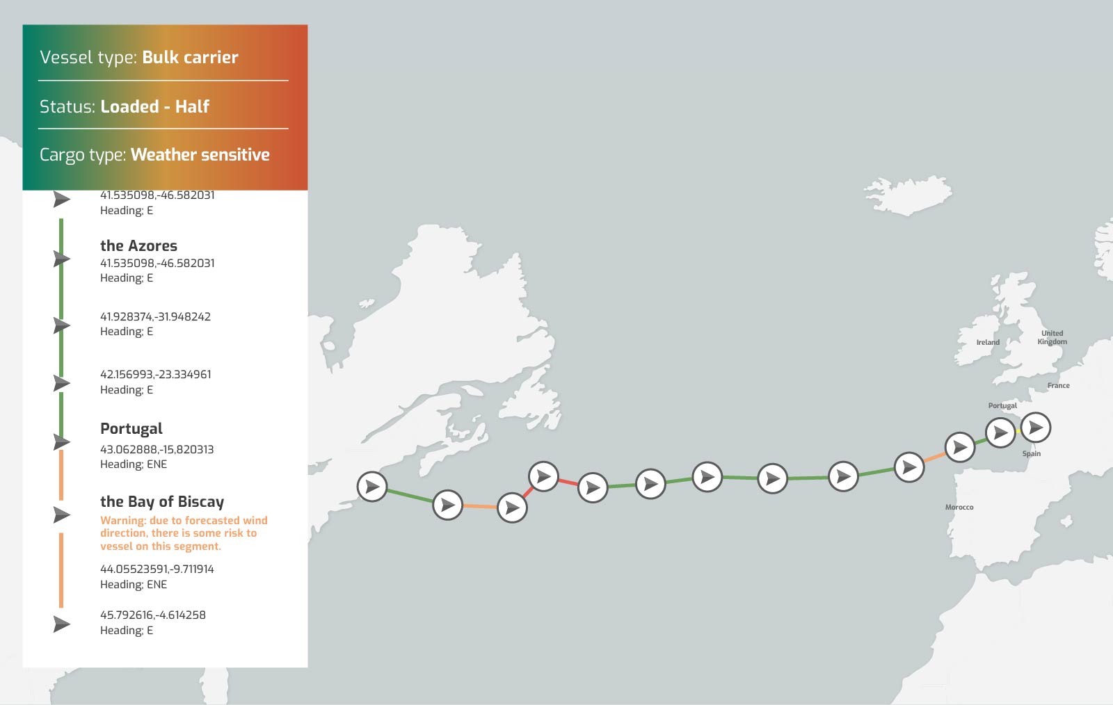
Vessel risk level
By default, all legs are considered “green” when we start. If, at any location inside the leg – in the time the vessel is expected to cross that part of the leg – we have a potential risky weather condition, the leg will receive either an amber or a red result, and an indication of what was the condition that triggered it.
Risk aspects
Taking the given vessel and commodity characteristics AND Spire’s forecasted weather data, the Insights service will define the risk value for each leg. Here are examples of the weather attributes that affect each of the risk aspects mentioned (Vessel, Cargo, Crew):
Vessel risk

Hazardous checklist
Visibility
Ice accretion (basic)
Wind (general)
Wind gust
Wind waves
Waves
Swell
Air pressure*
Storms*
Cargo risk
![]()
Hazardous checklist
Commodity maintenance – (dew point)
Commodity maintenance – (temperature)
Commodity maintenance – (humidity)
Wind (general)
Wind (gust)
Wind (waves)
Waves
Swell
Crew risk
![]()
Hazardous checklist
Wind (general)
Wind (gust)
Wind (waves)
Waves
Swell
Crew functional temperature
*Future addition
Efficiency insights – how does it work?
1
You can easily analyze more than one route to identify the most optimal trajectory to sail through. You enter the details of your ship, the waypoints for your potential journey, and your cargo characteristics into the API.
2
Spire’s Efficiency Insights will comb through this and merge it with the weather forecast data for that specific route to deliver actionable insights through a coloured spectrum.
3
Each part of the queried route is represented by one out of five color options: Red, Amber, gray, Light Green, or Green. Those indicate the expected efficiency level for each leg. The reason for each color will also be given, so you’ll know what to expect.

![]() How can I reduce my sea-margin cost?
How can I reduce my sea-margin cost?
![]() How can I better predict ETAs?
How can I better predict ETAs?
![]() How can I reduce fuel consumption to improve CII?
How can I reduce fuel consumption to improve CII?
Product specifications
- Coverage: Global
- Temporal Resolution: 10 days forward: hourly data to 48 h, 3-hourly to 120 h (5 days); 6-hourly to 240 h (10 days)
- Spatial Resolution: 1/8th-degree (12km) resolution
The analytics behind Spire’s Weather Insights
1
Data collection
Spire’s satellites collect thousands of radio occultation profiles every day that are used as an input along with other sources of weather data to power Spire’s proprietary global weather forecast
2
Data extraction
Easy to use APIs with different quick and efficient ways of extracting weather data to match your company needs
3
Fusion
Merge maritime weather data with vessel and cargo characteristics, including the heading and load of the vessel
4
Analysis
Using the fused data, Spire’s proprietary algorithms will analyze the inputs to generate the risk and efficiency value for each leg of the planned journey
What our customers say
“The Spire Weather Forecast excels for open ocean weather forecast accuracy. The level of development and speed of innovation that Spire is putting into its models continues to impress us.”
Nick Olsen
Marketing & Business development manager – Predictwind
![]()

“We’re a specialist company that does remote sensing, so we know the value that satellite technology brings to the table. This is why we’re so happy Spire provides such data points using satellite technology as it covers the entire world without any gaps. Before, the level of accuracy was only 75% but now with Spire’s integration, it’s gone up to 95%.”
Rishikiesh Sapre
Co-founder – Mantle Labs
![]()
“Weather routing has the potential to drive greater efficiency and emissions reduction as open-ocean conditions greatly impact performance. Partnering with Spire Weather puts genuinely market leading data into the hands of more users allowing them to enhance vessel performance.”
Soren Meyer
CEO – Zeronorthx
![]()

Weather forecast use cases
How port weather forecasts can help with maritime operations
There may be ways to better plan berth allocation or vessel maneuvers taking a weather forecast into account.

The economic impact of climate change on ports
What do you do if the world’s busiest port shuts down due to poor weather conditions?
5 Ways Weather Insights Can Help Ports Thrive
Despite the innovations in modern technology, transportation and communication, more than 80% of the world’s trade is carried through sea-faring vessels.