Enhanced Satellite AIS – Delivering more robust ship tracking data from around the globe
90% of goods are moved by the sea: Do you know where your ship is?
When you own or operate a vessel, you need to track it 100% of the time to accurately plan voyages, optimize profits, and drive value for your enterprise.
Maritime transport is the backbone of global trade and the world economy. Everyday, each of us relies on something that is transported across the oceans. If you put gas in your car or heated your house, put clothes on your back or food on your table–maritime transport made it possible. Yet, we don’t often stop and think about it, our oceans operate as a 24-hours a day, seven days a week, highway for container and cargo ships, bulkers, tankers, and livestock vessels.
When you operate a maritime enterprise you need to track vessels around the clock and know their whereabouts every single day. Fuel is measured, routes are fretted over, and profit margins tighten with the ebb and flow of the global economy. Yet tracking vessels is not a perfect system. Many rely on AIS data, which is laden with gaps in data where ships aren’t visible. These gaps in tracking data can wreak havoc with a profit tight budget and leave vessel owners and operators guessing when and where their vessel will return to waters where AIS data is reliable.
AIS data gaps in high traffic zones and busy shipping lanes have been a challenge in the maritime industry for decades. These gaps impact ship safety, trading, revenue, and insurance claims. Spire Maritime created Enhanced Satellite AIS to solve the growing data gap problem.
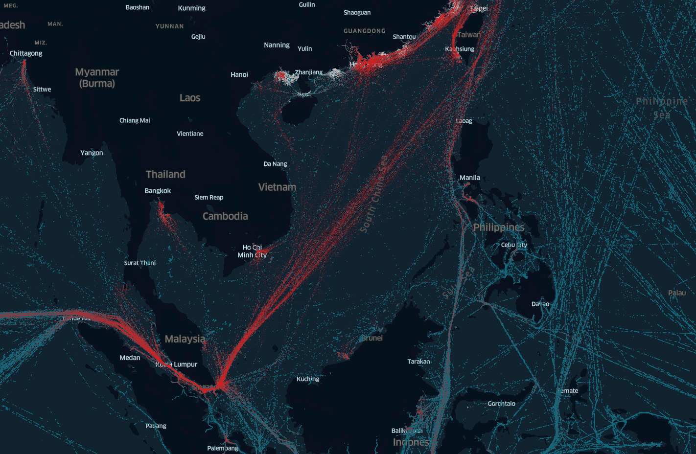
Missing ships and data gaps in regions like the South China Sea and the English Channel were a common challenge in the maritime industry. These gaps in coverage caused ship owners and operators to hypothesize about when a ship would appear again and how much time would have passed. These gaps make planning port arrivals and ensuring crew and cargo safety challenging.
Enhanced Satellite AIS is a next-generation solution from Spire Maritime. It is the new industry standard for global vessel tracking, delivering unprecedented data in the busiest shipping lanes and congested ports.
Meet Enhanced Satellite AIS, the solution for more robust ship tracking data. Download our free ebook to learn more.
In this ebook you’ll learn more about Enhanced Satellite AIS, a Spire Maritime data solution that provides more data in problem areas, like high traffic zones. We’ve included customer case studies detailing how our data helps companies compete in crowded markets.
How maritime data
reduces costs and
builds transparency
A closer look at how Maritime data
has a direct impact on profitability
The Enhanced Satellite AIS Difference
Enhanced Satellite AIS is layered with Satellite and Terrestrial AIS to achieve more complete data coverage, even in remote oceans and high traffic zones. Enhanced Satellite AIS allows you to benefit from thousands of satellite-enabled AIS receivers traveling throughout the busiest shipping lanes in the world. It provides an unprecedented frequency of position updates in areas that are out of the reach of terrestrial collection and overwhelm other satellite AIS providers.
Our more than 1,500 satellite-enabled AIS receivers track vessels and the traffic within 60 nautical miles and send this data to communication satellites. This process occurs at least every six minutes.
 Terrestrial, Satellite and Enhanced Satellite AISf
Terrestrial AIS Satellite AIS Enhanced Satellite AIS
Solving Industry Challenges: One vessel at a time
Solving industry challenges is a core value at Spire Maritime. We understand that market solutions are not a “one size fits all” situation. Our solutions are customizable to solve your unique business challenges. Enhanced Satellite AIS is unique in that it combines three types of AIS data and it’s customizable by area, time of day, ship size, and many other indicators.
We are the trusted source for maritime data and that means you can count on our data to be comprehensive and reliable. Spire Maritime truths:
- If your data is not accurate, you won’t achieve the desired outcome
- If your data is not reliable and delivered consistently, you will not see the benefits of using it
- If your data is not easy to access, easy to visualize, and solve for your unique use case, you won’t use it
Our data is always accurate, completely reliable, and easy to use. We offer a full slate of tutorials to help get you started and all of our products and services include support from our engineering team.
Spire Maritime is dedicated to creating innovative products so you can unlock the data advantage quickly and easily-every time.
Here’s what our customers are saying:
We’re proud of how our customers are using Enhanced Satellite AIS to unlock markets and how our data is generating tangible actions to help accurately identify sanction violations and track global trade.
![]()
Enhanced Satellite AIS provides situational awareness of possible sanction violations for our customer, Geollect
Read more about how Geollect leverages Enhanced Satellite AIS for a complete picture of the maritime landscape to find sanction violators.
Big Data: It’s a mindset
We live in a world of rapid technological advancements where mobile phone apps simplify everything from bill paying to friend tracking. There is no doubt, our lives are inundated with data. The question on everyone’s mind is how do we turn that data into effective business goals?
All businesses are different and all businesses have goals that are unique to their future plans. Shipping, for example, is essential for worldwide supply chain reliability and the foundation for global commerce. As the conduit of world trade, maritime is the most efficient and cost-effective mode of transportation for shipping goods. Shippers have unique use cases based on their cargo, vessel size, and selected sea routes. Enhanced Satellite AIS can provide unprecedented data coverage in remote areas and busy shipping lanes. This seamless coverage can be used to select the most time effective routes, chart fuel economy, and track supply and demand of goods. You can filter to track only tankers, or dry bulkers, or containerships. You can sort by tonnage. Weather forecast data can be added to plot storms brewing at sea so you can select alternate routes or slow down your travel speed.
A 2015 Gartner survey estimated that more than 75% of companies were investing or planning to invest in big data and that has happened. Now, many companies are using data to refine their operations and plan for the future. Data, especially within the maritime industry is becoming a go-to solution for ETA estimating, route selection, and emissions compliance.
Data needs to be accurate and comprehensive and your provider needs to understand your goals. It doesn’t have to be complicated to get started using data. Spire Maritime customizes datasets and delivers data in easy to use APIs.
Satellite Communication Obstacles in Maritime High Traffic Zones
Leveraging big data to identify outcomes and study variations to determine the most effective route allows maritime operations to evaluate revenue cycles and target processes for optimization. AIS coverage gaps on busy maritime routes has long been a challenge as the gaps create holes in time periods and make estimating challenging. More complete data coverage, especially in busy shipping lanes and remote oceans like the South China Sea and the English Channel, is essential for building digital twins, fueling machine learning models, and anomaly detection.
Download a free sample containing Terrestrial, Satellite and Enhanced Satellite AIS
All global fishing vessels’ last position over a period of 24 hours.