Hidden corridors: How soil moisture and climate shape coca production and trafficking dynamics in Colombia
- Operational context and policy relevance
- Insights for enforcement & policy
- Limitations & safeguards
- Environmental & geographic drivers of coca expansion
- 2023 - 2024 precursors: Environmental cycles shaping accessibility
- 2025: Recent environmental and trafficking dynamics (April - October)
- Spire Soil Moisture analysis: Terrain accessibility and anomalies
- Conclusion
Meghan Mussoline
Product Marketing Manager, Spire Weather and Climate
Across Colombia’s southern frontier, coca cultivation continues to expand – not only because of enforcement pressures or economic incentives, but because the terrain itself encourages it.
International outlets such as Reuters and Al Jazeera highlighted this surge and expansion, noting that coca production remains concentrated along Colombia’s southern borderlands despite renewed eradication efforts. When these reports are combined with Spire’s Soil Moisture Insights, a clearer picture emerges: one that shows how terrain conditions create hidden corridors, how accessibility changes with rainfall and drying cycles, and how government agencies can use environmental intelligence from Spire’s DeepInsights™ Cirrus platform to detect operational changes and anticipate mobility across frontier terrain.
The fact is that expansion is shaped as much by environmental opportunities as by policy or enforcement cycles. While traditional climate and rainfall data tell part of this story, the ground’s response (i.e., how long soils stay wet or dry) ultimately determines when fields can be planted, roads can be traveled, or patrols can move.
Spire’s Soil Moisture Insights measure land surface changes in near real time, revealing how terrain saturation and drying cycles influence accessibility and movement across complex terrain. Rather than forecasting activity, these observations provide the foundation for the enforcement and policy insights explored below.
This report integrates open-source reporting from 2023 through 2025 with Spire’s Soil Moisture Insights to examine how environmental conditions shape coca production and mobility across southern Colombia. The 2023–2024 section outlines the environmental precursors that drove coca expansion, followed by a 2025 update capturing current terrain patterns across the Putumayo–Nariño corridor. Together, they illustrate how ground conditions continue to influence accessibility and how environmental intelligence provides agencies with an early-warning view of operational change.
Operational context and policy relevance
This analysis demonstrates how Spire’s Soil Moisture Insights can complement government programs designed to reduce illicit coca cultivation and strengthen terrain-based enforcement planning. In Colombia, this intelligence can support agencies working to prevent coca expansion by revealing which areas are most accessible for suppression or alternative development efforts.
Insights for enforcement & policy
Spire’s soil-moisture intelligence provides more than environmental awareness – it delivers predictive mobility intelligence. By measuring how quickly specific terrain in certain regions transitions from saturated to stable conditions, soil moisture data accessed via Spire’s DeepInsights Cirrus platform identifies when and where movement across remote regions becomes possible. These insights allow enforcement, logistics, and policy teams to anticipate accessibility, rather than react to it.
For operations in frontier terrain, soil moisture is a far stronger indicator of mobility than rainfall. Rainfall data shows when storms occur; soil moisture data reveals how long their effects last. This distinction transforms climate information into actionable intelligence, supporting everything from patrol scheduling to aerial ISR timing and eradication or enforcement campaigns that depend on soil stability. In civilian applications, the same insight can guide infrastructure maintenance, humanitarian access, or post-flood recovery logistics.
This same methodology can be replicated across other frontier environments, from West Africa’s Sahel corridors to Southeast Asia’s borderlands, wherever mobility depends on terrain state.
Limitations & safeguards
Soil data quantify environmental feasibility, not human intent. While soil-moisture anomalies reveal when terrain can or cannot support movement, they should always be combined with complementary intelligence streams (such as HUMINT, SIGINT, or geospatial observation) to interpret behavior.
To prevent misuse or adversary adaptation, high-resolution soil moisture outputs should remain restricted to vetted users and used only within secure operational frameworks. These safeguards ensure environmental intelligence enhances decision-making without overextending inference.
Environmental & geographic drivers of coca expansion
Colombia’s surge in coca cultivation has deep roots in geography and land-use dynamics, as well as in enforcement and policy cycles. According to the 2023 UNODC Coca Survey, the national coca area reached 230,000 hectares by 2024, the highest figure since monitoring began.
The most significant increases occurred in Putumayo, Nariño, and Cauca, where mountainous terrain and tropical rainfall provide both fertile growing conditions and logistical cover for processing and transport. Complementary analyses by the IUCN and the Global Initiative Against Transnational Organized Crime link this expansion to broader patterns of deforestation and informal road development in the Amazon fringe – physical transformations that reshape access routes and settlement patterns across southern Colombia.
Deforestation plays a direct enabling role in coca expansion. The clearing of forests opens remote terrain to roads and human movement, allowing farmers and traffickers to reach areas that were previously inaccessible. Newly exposed soils also create short-term agricultural openings (fertile ground for short-cycle crops like coca) before nutrients are depleted. These same clearings fragment the forest canopy, making cultivation easier to conceal across dispersed patches while leaving lasting environmental signatures visible in soil-moisture data.
While policy attention often centers on the social and economic drivers of coca cultivation, environmental accessibility remains a determining factor that is rarely quantified.
Seasonal cycles dictate the rhythm of both production and enforcement. During the rainy months, saturated soils can isolate remote areas, forcing traffickers to rely on rivers and small airstrips. During dry periods, unpaved tracks reopen, facilitating the transport of precursors and products across the forest frontier. Traditional rainfall datasets capture when storms occur, but not how long soils remain saturated after they pass. Soil moisture, rather than rainfall, determines when eradication teams can access target areas and when illicit networks can move resources through them.
This difference between rainfall and soil response underscores the need for a new kind of monitoring: one that tracks the persistence of saturation and drying cycles over time.
2023 – 2024 precursors: Environmental cycles shaping accessibility
Open-source reporting and field studies from 2023 to 2024 reveal a clear sequence of environmental and logistical changes across Colombia’s southern coca frontier. Together, they reveal how fluctuations in land accessibility and seasonal moisture shaped both coca cultivation and the movement of goods across the Putumayo–Nariño corridor.
June – September 2023 – expansion during extended dry conditions
In mid-2023, an unusually long dry window altered movement across Colombia’s Andean-Amazon frontier. Roads that had been impassable for months hardened under weeks of low rainfall. Regional journalists described the renewed presence of truck and motorcycle traffic near Puerto Asís, Mocoa, and Orito, where compacted soils reopened interior routes used for transportation and supply.
According to Colombia’s meteorological institute IDEAM, rainfall totals in Putumayo and Nariño fell 25-40 percent below seasonal norms. These conditions allowed eradication patrols to reach farther upriver but also enabled farmers to move fertilizer and fuel into newly accessible clearings.
Environmental organizations monitoring deforestation detected corresponding spikes in forest clearing and road cutlines during July and August. The IUCN’s 2023 report described this as a “seasonal pulse” of land conversion: once soils dried, machinery entered to fell timber and plant short-cycle crops, particularly coca, before the rains returned.
Satellite alerts from Global Forest Watch also indicated ongoing tree-cover loss in Putumayo, including in areas of intact forest, corroborating physical clearing activity in regions under pressure from frontier expansion.
Key implication:
The extended dryness of mid-2023 coincided with a surge in frontier accessibility, which hardened unpaved roads and facilitated the transport of inputs to newly accessible terrain, triggering a short-term wave of deforestation and coca cultivation.
March – April 2024 – Saturation and disrupted access
By early 2024, the return of Colombia’s rainy season dramatically shifted mobility across the southern frontier. Continuous downpours triggered flooding and landslides, ultimately leading to weeks of isolation in Putumayo, Cauca, and Nariño, disrupting both licit and illicit movement across the region.
The national meteorological agency IDEAM reported above-average rainfall totals across the southwestern Amazon piedmont from February through April, noting that monthly precipitation exceeded climatological norms by 30–50 percent in parts of Putumayo. Roads connecting Mocoa, Villagarzón, and Puerto Guzmán were repeatedly closed due to landslides, according to dispatches from El Espectador and local civil-defense bulletins.
Independent coverage from InfoAmazonia mapped flooding along the Putumayo River basin, where satellite imagery showed overbank inundation of low-lying forest and agricultural plots. Journalists with Vorágine documented how traffickers and residents adapted to the changing conditions, shifting to river transport for supply shipments while relying on small airstrips on higher ground for essential goods.
Officials interviewed by El Tiempo described a temporary stand-down of land-based eradication efforts as vehicles became bogged down or stranded in saturated terrain. Field accounts from humanitarian workers further noted that isolated communities turned to river commerce to offset supply shortages, creating temporary micro-economies along navigable stretches of the Putumayo and Caquetá rivers.
Key implication:
The early-2024 rains underscored the region’s environmental sensitivity – how short bursts of extreme precipitation can immobilize land routes, redirect trafficking toward river corridors, and reshape local economies until terrain conditions stabilize.
May – July 2024 – Dry-down and frontier road expansion
As the rains subsided in mid-2024, dry conditions once again reshaped movement and land use across Colombia’s southern frontier. Soil surfaces hardened after months of saturation, reopening overland routes that had been closed since the start of the year.
According to the Associated Press (AP), deforestation and informal road construction accelerated in the Amazon fringe of southern Colombia during this period, particularly around Mocoa, Puerto Guzmán, and northern Caquetá. Field organizations cited by AP reported the return of heavy machinery and logging trucks to areas that had been inaccessible during the rains.
Local coverage from La Silla Vacía described how the “verano” (the brief mid-year dry season) enables a surge in transport activity as rural roads dry out. In interviews with community leaders, the outlet noted that large vehicles carrying timber, fuel, and agricultural inputs used the short dry window to move goods deeper into the forest frontier, where new road cutlines often precede coca planting and settlement expansion. Environmental alerts from Global Forest Watch also recorded localized spikes in tree-cover loss during June and July, corresponding to these newly reopened corridors in Putumayo and Caquetá.
Key implication:
The mid-2024 dry-down reopened overland corridors, enabling the construction of access routes that underpin both coca cultivation and associated illicit economies.
August – October 2024 – Variable terrain and adaptive mobility
By late 2024, conditions across Colombia’s southern frontier had become increasingly erratic. Alternating weeks of drought and heavy rainfall created unstable terrain, upending predictable transport patterns along the Putumayo–Ecuador border.
InSight Crime reported that trafficking networks operating in the region began alternating between land and river routes as weather swings disrupted ground access. Interviews with local officials revealed that these shifts were often unplanned, responding to sudden road washouts or rapid dry-downs that reopened dirt tracks within days.
The International Crisis Group noted similar volatility in its late-2024 regional brief, warning that environmental instability compounded security and logistical challenges for both state and non-state actors. Municipal authorities in Puerto Leguízamo and La Hormiga reported repeated infrastructure damage from back-to-back storms, followed by intense drying that left unpaved roads cracked and impassable.
Local coverage from El Espectador described how rural residents adjusted by relying on motorcycles, mule convoys, and riverboats within the same month, illustrating how rapidly mobility decisions in the coca frontier now hinge on terrain conditions rather than fixed routes.
Key implication:
Late-2024 volatility underscored the frontier’s growing environmental unpredictability. As alternating extremes of saturation and drought reshaped ground conditions in a matter of days, both enforcement and trafficking operations became increasingly reactive, dependent on real-time awareness of terrain state rather than established seasonal patterns.
These recurring wet–dry cycles established a clear environmental rhythm long before 2025: rainfall closes access, dryness reopens it, and rapid oscillations drive uncertainty for both farmers and enforcement teams.
Until now, these dynamics were documented qualitatively through field accounts and local reporting. Spire’s soil-moisture intelligence now provides quantitative confirmation, revealing how these mechanisms persist and evolve in real time.
Share on Facebook Share on Twitter Share on LinkedIn
2025: Recent environmental and trafficking dynamics (April–October)
April – May 2025 – Flooding, saturation, and isolation in the Putumayo Basin
In early to mid-April 2025, heavy rainfall and river overflow once again brought localized flooding to the lower Putumayo corridor, particularly around Puerto Leguízamo and neighboring river settlements near the Ecuador border. The surge in water levels constrained access along both river and overland channels. According to a UN OCHA Regional Situational Update, flooding in Bajo Putumayo displaced or otherwise affected roughly 3,300 people as water levels rose in the Putumayo and Caquetá Rivers.
At the same time, Mongabay reported that between October 2024 and March 2025, over 11,000 hectares of forest in the Putumayo department were cleared, and approximately 80 kilometers of irregular (mostly dirt) roads were carved through forest margins, particularly in Puerto Guzmán and eastern Putumayo districts. These road cutlines were often flanked by newly deforested patches, suggesting that the forest edges were actively being penetrated.
The combination of rising river levels and fresh road incursions suggests a dual pressure on frontier mobility:
- The flooding would have limited overland transport, particularly via small secondary tracks and forest roads.
- The new road cuts, however, suggest that once soils began to dry, traffickers and land-clearing actors expected or anticipated windows of accessibility.
Operationally, this pattern shows how traffickers and land-clearing actors plan ahead of environmental shifts: they build during isolation, anticipating terrain recovery.
AOI (Area of Interest) 1 (Putumayo River Basin) will test this behavior using Spire’s soil-moisture anomaly data to measure how quickly soils transitioned from saturation back toward dryness between April and June 2025.
July – August 2025 – Mid-year dry-down, road reopening & deforestation pressure
By mid-2025, a clear dry-down across southern Colombia reopened access routes that had been saturated earlier in the year. Reports from Puerto Asís, Mocoa, and the northern edge of Caquetá described renewed vehicle and machinery traffic along secondary forest roads as soils hardened and transport resumed.
In its article “Deforestation & Illegal Roads Advancing Fast in Colombia’s Largest Natural Area“, Mongabay documented that during early 2025, roughly 22 kilometers of illegal roads were cut and 856 hectares of forest cleared in the Llanos del Yarí–Yaguará reserve, underscoring that road-building remains a key tactic for penetrating remote regions.
At the national scale, Colombia’s Environment Ministry reported a 33 percent decline in deforestation during the first quarter of 2025 compared with 2024, dropping from about 40,000 to 27,000 hectares, but noted that this reduction was concentrated in protected Amazon parks. Pressure along frontier departments such as Putumayo persisted, particularly where dry conditions allowed access for clearing and construction.
By late July, that temporary reprieve had reversed. Reuters reported a 43 percent year-on-year surge in Amazon deforestation, driven by fires, land grabbing, and unregulated road expansion, including in areas tied to illicit cultivation.
Together, these signals point to a consistent environmental rhythm: once the rains recede, soil drying rapidly restores mobility, enabling both legitimate and illicit actors to move equipment deeper into the forest frontier. In Putumayo and adjacent Caquetá, this mid-year hardening of terrain likely reopened unpaved roads and set the stage for the next cultivation cycle – conditions that Spire’s Soil Moisture Insights can quantify through declining soil-moisture anomalies during July–August.
AOI 2 (Puerto Asís–Mocoa Corridor) focuses on this overland axis where soil drying and re-hardened tracks correspond to the July–August expansion window. Soil moisture anomaly data for this region will be used to quantify the transition from wet to dry conditions that reopened these transport routes.
September – October 2025 – Volatility, route switching, and frontier adaptation
From September 5 through mid-October 2025, terrain and access across southern Caquetá and western Putumayo, especially near La Hormiga and Solano, became increasingly volatile – forcing dynamic adaptation by traffickers and farmers. A Reuters article highlighted that many frontier zones remain cut off from basic infrastructure; roads are unpaved, utilities are absent, and seasonal access is uncertain.
This kind of reporting underscores that even small shifts in soil saturation or ground hardness can open or close access routes entirely. In such conditions, traffickers and transporters adapt continuously, shifting from river to motorcycle or mule routes during saturation, then back to small airstrips or forest tracks once the ground hardens. These short-lived mobility windows depend directly on soil stability rather than rainfall timing, a dynamic measurable through daily soil moisture anomaly data.
In practice, these tactical shifts mean mobility decisions become reactive to terrain conditions on weekly or even daily scales – a regime that soil-moisture anomaly data is especially well positioned to detect and corroborate.
AOI 3 (Upland Caquetá Transition) captures this pattern of rapid alternation, allowing Spire’s soil moisture time-series data to quantify the volatility that Reuters described qualitatively.
Integrated interpretation: What these trends suggest
- Recurrence of the seasonal cycle
The April flooding, mid-year dry pulse, and late-year volatility map closely onto the patterns documented in 2023–2024. These are not one-off events but a repeating environmental rhythm shaping frontier access. - Pre-positioning strategy
The road cuts and deforestation activity reported even during wet months suggest that actors anticipate favorable terrain windows. They position infrastructure just behind canopy lines so that, as soon as the soil dries, they can expand rapidly. - Frontier as a pulse system
The frontier doesn’t expand monotonically – it pulses. Some months it contracts under saturation, other months it surges under dryness, and then adapts under volatility. This calls for intelligence systems that detect when and where mobility becomes feasible. - Sensitivity to thresholds
Terrain conditions likely cross critical thresholds: small shifts in soil moisture might flip a route from impassable to passable. Open-source reporting hints at these edges (road washouts, closures, transport mode shifts) but cannot quantify exactly where or when those thresholds occur. - Role of disparate pressures
The mixed deforestation data (declines in some quarters, surges in others) suggest that enforcement, governance, and local resistance can modulate frontier expansion. Soil-moisture data helps disaggregate environmental constraints from policy constraints.
Spire Soil Moisture analysis: Terrain accessibility and anomalies
Spire’s Cirrus platform provides near–real-time and historic satellite-derived soil-moisture intelligence that captures terrain conditions invisible to conventional rainfall data. Across Colombia’s southern frontier, Spire’s Soil Moisture Insights validate how saturation and drying cycles shaped movement, cultivation, and enforcement activity from 2023 through 2024.
Three areas of interest (AOIs) were analyzed for 2025 to illustrate how soil-moisture anomalies influence ground accessibility and transport feasibility along the coca frontier:
- AOI 1 – Putumayo River Basin: Riverine corridor from Puerto Leguízamo to the Ecuador border.
- AOI 2 – Frontier Road Network (Puerto Asís–Mocoa Axis): Unpaved routes and secondary roads linking interior coca regions.
- AOI 3 – Upland Agricultural Zone (Northern Caquetá): Transition belt between cleared forest and high-elevation cultivation zones.
AOI 1: Putumayo River Basin (April – June 2025)
Flood persistence and recovery across the lower Putumayo.
Spire’s Soil Moisture Insights for the lower Putumayo River Basin confirm a short but intense flooding phase followed by a rapid drying period.
Between April 5 and April 29, 2025, anomalies averaged +0.08 to +0.18 m³/m³, indicating sustained saturation along the river corridor near Puerto Leguízamo and neighboring lowlands. These conditions align with UN OCHA’s late-April 2025 situational update and InfoAmazonia’s reporting of river overflow and community displacement in Bajo Putumayo.

Figure 1a. Soil moisture anomaly map – April 12, 2025 (high saturation)
Beginning April 30, anomalies reversed sharply negative (–0.03 to –0.08 m³/m³) through May 12, showing that surface soils dried faster than climatological norms.
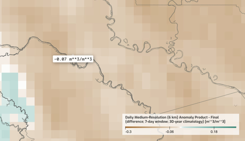
Figure 1b. Soil moisture anomaly map – May 5, 2025 (rapid dry-down)
This 7–10-day transition marks a critical shift from isolation to renewed accessibility, quantifying the short recovery window described in field reporting and supporting evidence of early logistical repositioning along river and forest tracks.
AOI 2: Puerto Asís–Mocoa Corridor (June – August 2025)
Dry-down and renewed overland accessibility across the interior frontier.
Spire’s soil-moisture anomaly data, as analyzed in the DeepInsights Cirrus platform, show a sustained drying trend across the Puerto Asís–Mocoa transport corridor during July 2025, confirming the terrain recovery described in field reports. Between June 20 and July 25, 2025, anomalies declined from near-neutral (+0.01 to +0.03 m³/m³) to markedly negative (–0.08 to –0.14 m³/m³), indicating rapid hardening of surface soils along secondary forest roads.
In late June, near-neutral anomalies (+0.01 to +0.03 m³/m³) reflected residual moisture from preceding rainfall. Terrain remained partially saturated, limiting vehicular access.
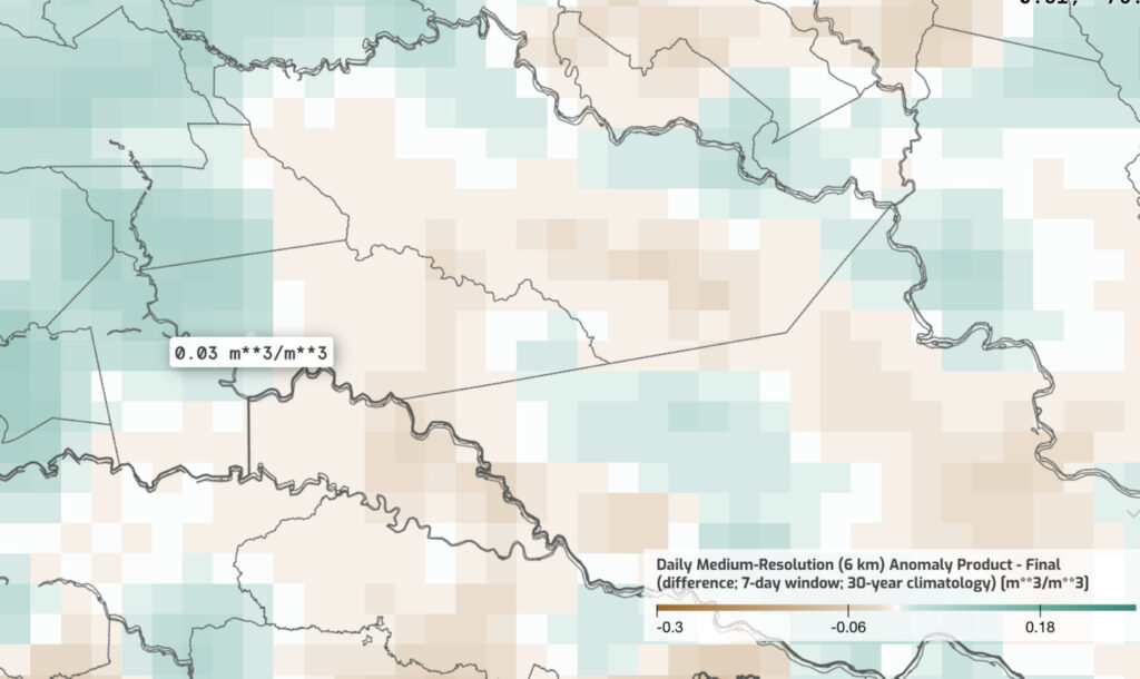
Figure 2a. Soil moisture anomaly map – June 20, 2025 (pre-dry-down)
By mid-July, negative anomalies (–0.08 to –0.14 m³/m³) extended across the Puerto Asís–Mocoa corridor, marking widespread surface hardening. This period corresponds to the reactivation of overland transport described in multiple field and media reports.

Figure 2b. Soil moisture anomaly map – July 17, 2025 (peak dryness)
By early August, partial moisture recovery (–0.02 to 0.05 m³/m³) signaled the end of the dry window, reducing road accessibility once again.
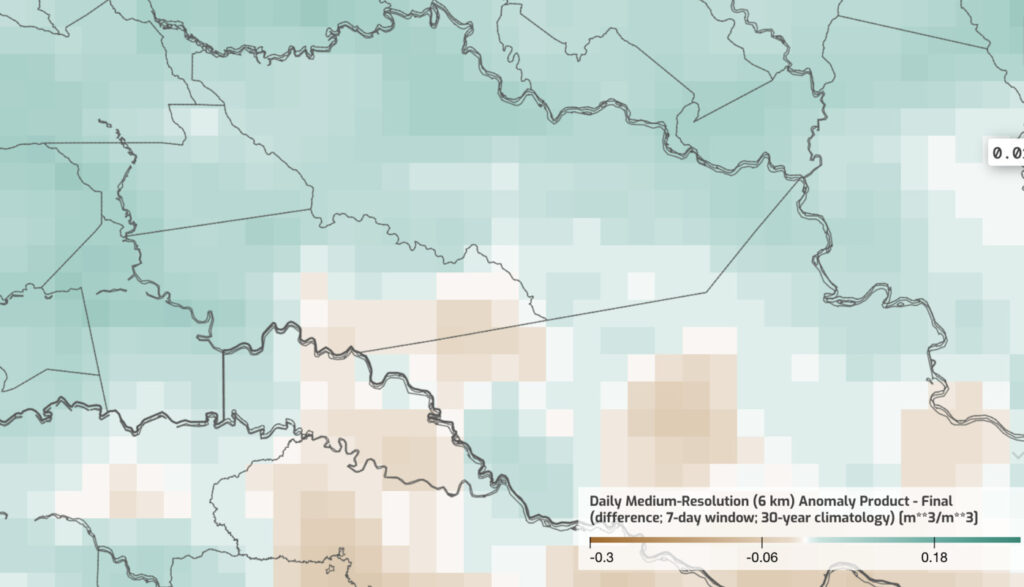
Figure 2c. Soil moisture anomaly map – August 11, 2025 (end of dry-down period)
In practical terms, this sequence marks the transition from water-logged to compacted soils – conditions that allow heavy vehicles and machinery to traverse previously inaccessible terrain.
By late July, these drier anomalies formed a continuous belt along the Puerto Asís–Villagarzón–Mocoa axis, suggesting a corridor-wide reopening of ground mobility. The spatial extent mirrors patterns visible in Sentinel-derived deforestation alerts and supports open-source accounts of intensified land clearing and road extension.
This one-month transition quantifies the environmental recovery window that reopened ground mobility and enabled road expansion across southern Colombia’s forest frontier.
AOI 3: Upland Caquetá Transition (September – October 2025)
Volatile terrain conditions and adaptive mobility at the frontier edge
Spire soil-moisture anomaly data for the upland Caquetá transition zone confirm the environmental volatility reported in open-source coverage from September to October 2025. This region, spanning the foothills around La Hormiga, Solano, and the upper Caquetá River basin, experienced rapid oscillations between saturation and dryness, creating unpredictable ground conditions that directly affected transport and enforcement access.
Between September 5 and September 20, 2025, anomaly values shifted from strongly negative (–0.10 to –0.15 m³/m³) to near-neutral (–0.01 to +0.02 m³/m³) within roughly two weeks, indicating abrupt re-wetting of previously hardened soils after heavy rainfall events.

Figure 3a. Soil moisture anomaly map – September 10, 2025 (dry-phase terrain)
By late September, renewed saturation (+0.06 to +0.12 m³/m³) spread across interior valleys and road corridors, followed by another reversal toward dryness in early October. These swings compressed normal seasonal patterns into short, irregular pulses.

Figure 3b. Soil moisture anomaly map – September 26, 2025 (re-saturation period)
In operational terms, these alternating phases reflect the “stop-start” mobility dynamics described in local reports: motorbike and mule routes reopening for days before becoming impassable again, and enforcement teams facing abrupt changes in ground trafficability.
This anomaly sequence quantifies that volatility, illustrating how soil conditions, rather than rainfall totals alone, govern real-world accessibility in Colombia’s southern uplands. Rapid shifts of 0.10 to 0.15 m³/m³ within two-week windows represent threshold crossings that can flip a route from passable to impassable.
The AOI 3 pattern reinforces the broader finding: Colombia’s coca frontier now operates as a pulse system, where environmental thresholds, not calendars, dictate movement. For intelligence and enforcement planning, daily soil-moisture monitoring provides the situational awareness needed to anticipate when those pulses will open or close.
Conclusion
Across Colombia’s coca frontier, Soil Moisture Insights validated how rapid environmental change governs accessibility, from flooded isolation to reopened corridors and volatile uplands, reinforcing the operational insights outlined above. These terrain-driven cycles define when operations, cultivation, and enforcement can move and when they cannot.
Spire’s DeepInsights™ Cirrus platform and soil-moisture visualizations capture these shifts with daily, global coverage and long-term baselines drawn from over 40 years of historical data, converting climate variability into operational foresight. Soil Moisture Insights are also accessible via APIs at 6 km, 500 m, and 100 m (custom) resolutions, allowing clients to integrate terrain intelligence directly into their existing operational workflows or decision-support systems.
Whether for defense, law enforcement, or environmental management, Soil Moisture Insights delivers a clear strategic advantage: the ability to see when terrain itself becomes the variable that determines success.
Explore how Spire’s soil-moisture intelligence supports predictive mobility and terrain readiness in our DeepInsights Cirrus visualization platform or via our APIs.