


4U Satellite Specifications
Payload Volume97mm x 97mm x 213mm
PropulsionOptional
Satellite Design Life3-5 Years
Pointing Accuracy0.2°
Data Download (per sat per day)4GB
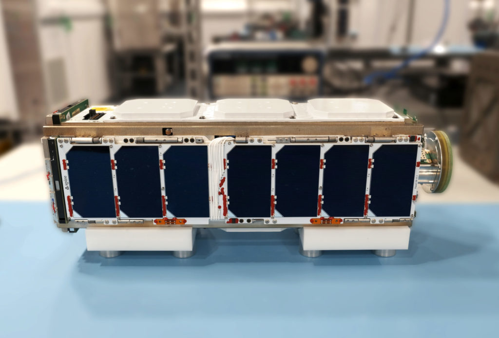
8U Satellite Specifications
Payload Volume220mm x 200mm x 97mm
PropulsionOptional
Satellite Design Life3-5 Years
Pointing Accuracy0.2°
Data Download (per sat per day)Up to 10GB
16U Satellite Specifications
Payload Volume220mm x 220mm x 335mm
PropulsionOptional
Satellite Design Life3-5 Years
Pointing Accuracy0.5°
Data Download (per sat per day)Up to 320GB
Federal solutions
Mission-critical satellite data and advanced space services built to protect, empower, and enhance operational resilience.
Spire Federal enables US Government agencies to address their mission challenges through our data analytics and space services solutions. We provide enhanced situational awareness facilitating smarter operational decision-making for US Civil Agencies, the Armed Forces, and the Intelligence Community.

Global data solutions delivered on resilient infrastructure
Spire Federal puts competitive Earth and ocean data directly into the hands of government users with unprecedented speed. Make key decisions and rapidly respond to emergencies with granular data collected from even the most remote, guarded areas. Our robust, redundant, and secure architecture is continuously hardened and updated.
Bespoke cubesat manufacturing and transport
Safely launch your own payload or work with Spire to build custom hardware, all based on our tried and tested LEMUR satellite constellation. Our scalable, cost-effective infrastructure and world-class manufacturing facilities mean your satellites can get to orbit faster with Spire than any other provider.
About the Federal Team
The Spire Federal services team has decades of experience providing IT, data analytics, and space solutions to NASA, NOAA, USAF, Army, Navy, and the intelligence community. Our Federal sales professionals previously held government roles with the armed forces, Office of Space Commerce, and White House OSTP. We stand at the ready with solutions for your greatest challenges.

Quintin Jones
Head of Spire North America
Two distinct paths to greater Earth intelligence
Global monitoring, near real-time data streams, and custom historical datasets collected by a constellation of low-orbit cube satellites equipped with multi-use radio frequency sensors.
Learn about our deal with NASA to provide tens of thousands of radio occultation data profiles per day.
Hosted payloads and custom-manufactured nanosatellites, transported on our reliable LEMUR 3U or 6U cubesat bus to low earth orbit.
Learn how the Australia Office of National Intelligence went from hosted payload order to orbit in less than 6 months.
Data solutions
Global, multi-domain situational awareness

Global AIS data for maritime intelligence
We deliver over 80 million AIS messages daily through our AIS message and vessels data feeds, providing groundbreaking accuracy and coverage even in high-traffic and remote zones.
ADS-B data for air tracking and monitoring
Access a streaming global ADS-B service and historical database to support application development, analysis, and strategic decision-making.
Earth intelligence & atmospherics
Our constellation leverages GNSS signals to collect atmospheric data used to improve weather forecasts, measure sea ice and soil moisture, and monitor various Earth properties.
Highly accurate weather forecasting
Spire offers a proprietary weather forecast model powered by our radio occultation data and custom predictive models, producing highly accurate, global high-resolution forecasts with over 100 discrete variables.
Space Services
Fast, reliable, and secure access to orbit

Spire offers hosted payload services for software defined radios (SDRs), custom antennae, and customer payloads. Spire Space Services is designed to accommodate new customer payloads quickly, enabling rapid rollout of new capabilities.

Spire’s reliable launch schedule and ability to design, assemble, and test our LEMUR satellites in-house allows for new bespoke sensors to go from design to launch in as little as six months.
Meet the LEMUR family
Spire relies on its internally developed LEMUR satellite bus to power its own data products. By building on this proven platform, you benefit from extensive on-orbit heritage and continuous design refinements, giving you a reliable, flight-proven foundation to confidently launch and scale your mission.


Case study
Spire Partners with Pole Star to Illuminate Dark Waters and Improve Search and Rescue Operations

Case study
Supporting Intelligence Communities: Australia ONI and Spire Partner to Develop Experimental AI-Powered CubeSat

They trust our data


Resources
Federal resources and insights

Building mission success with miniaturized satellite technology
The successes of space-based observation and data collection have never been so significant. And we’re doing it with smaller technology than ever before – a 6kg satellite.
Read more
The importance of global weather forecasts for U.S. Military and Civil Agency missions
Weather models help the U.S. military execute critical missions, federal engineering organizations create more resilient infrastructure, and scientists better understand climate change. By providing the data accuracy needed to safeguard military personnel and assets, global weather forecasting plays a pivotal role in today’s world.
Read more