Why U.S. Arctic Strategy Needs Space Capabilities
 Written by
Janie Yurechko
Senior Product Marketing Manager at Spire Federal
Learn how Spire’s unique Polar coverage provides mission critical insights in the Arctic
Climate change is humanity’s greatest generational challenge, creating obstacles for environmental and national security missions. As new trade routes emerge and great-power competition makes its way into the Arctic, accurate intelligence on sea ice, weather forecasts, and maritime tracking is critical. Spire is offering an all-in-one solution to support U.S. dominance in the Arctic from the ultimate vantage point – space.
Sea ice sets the scene
Declining levels of sea ice are an unmistakable sign of climate change’s impact on our planet. Record low levels of sea ice are leading to warming temperatures which affect sea level rise, ocean circulation, and weather patterns. Climate developments increasingly affect economies, industries, and transportation within the Arctic and around the globe, and pertinent data to help mitigate the effects of these changes is lacking. Critical missions such as search and rescue, safe marine operations, fishing, water quality, and climate change monitoring are all suffering from a lack of Polar observational data and an inability to access remote areas.
Spire is seizing the opportunity to provide more satellite coverage in the Arctic and Antarctic regions to measure the extent and height of sea ice and to monitor new waterways created by the melting ice. Over 65% of Spire’s cubesatellites are in polar orbit, offering high revisit rates in the polar region, thereby providing unprecedented vessel tracking coverage as well as highly accurate weather and climate intelligence. Spire data can provide an optimized Arctic solution to support both environmental and security interests due to the architecture of our satellite constellation and accuracy of our data.
Supporting opportunities and mitigating challenges with climate data
According to the Government Accountability Office, the Arctic holds 13% of the world’s undiscovered oil, 30% of undiscovered gas, and about $1 trillion worth of gold, zinc, nickel, and platinum. Melting sea ice is increasing usage of the Northern Sea, Northwest Passage, and Transpolar trade routes and potentially opening up new waterways to create new trade routes. Flooding and erosion have caused millions of dollars in property damage in Arctic Alaska indigenous villages, posing threats to lives, homes, and infrastructure and putting pressure on hazard mitigation efforts for federal and state agencies.
In-depth, accurate data on melting sea ice and human activity in the Arctic is critical to taking advantage of opportunities and mitigating regional challenges. However, this data is currently lacking and will continue to be elusive as Arctic monitoring satellites reach end of life.
In an open Polar Altimetry Gap Letter of Concern, over 600 scientists signed their names to address their concern over an expected lack of satellite altimetry data in the coming years. The scale and inaccessibility of the Polar Regions call for a collection of space-based observation techniques. Satellite altimetry offers a unique capability to monitor changes in the Polar Oceans and the height of land and sea ice. There are 7 satellite altimeters in orbit, but only two reach polar latitudes. CryoSat-2 and ICESat-2 were launched in 2010 with a design-life of 3.5 years and 2018 with a design-life of 3 years, respectively. CryoSat-2 is projected to reach end-of-life between 2024 and 2026. The European Commission initiated the CRISTAL polar altimeter as a high priority candidate mission, but the earliest launch date is projected for Q4 2027. Considering these factors, there will be a gap of 2-5 years in our polar satellite altimetry capability.
Spire’s earth intelligence capabilities can successfully fill this gap and support efforts to study indicators of climate change and its resulting impacts in the Arctic and Antarctic regions as well as globally. Spire provides a plethora of radio occultation (RO) data in the polar regions, where the low humidity permits the collection of data all the way to the surface. This unique set of near surface temperature measurements greatly enhances Arctic and Antarctic weather forecasts.
To collect measurements for sea ice extent, classification, and altimetry, Spire utilizes a novel GNSS low grazing angle reflectometry technique (GNSS-R) using radio occultation satellites. This technique has the potential to deliver high resolution (approximately 0.5 x 8 km footprint) and fast return rate (less than 24 hours) sea ice measurements.
With various data observations including sea ice age, extent, height, and weather forecasts for temperature, wind, and other ocean variables, Spire can provide an all-in-one Arctic Intelligence solution to meet research and mission needs.
SEA ICE EXTENT
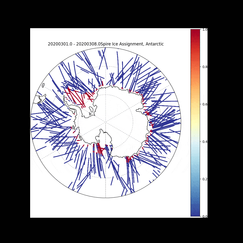
Spire Ice Detection from Grazing Angle GNSS-R in the Antarctic, data from March 2020, gridded at 5 km resolution
SEA ICE EXTENT
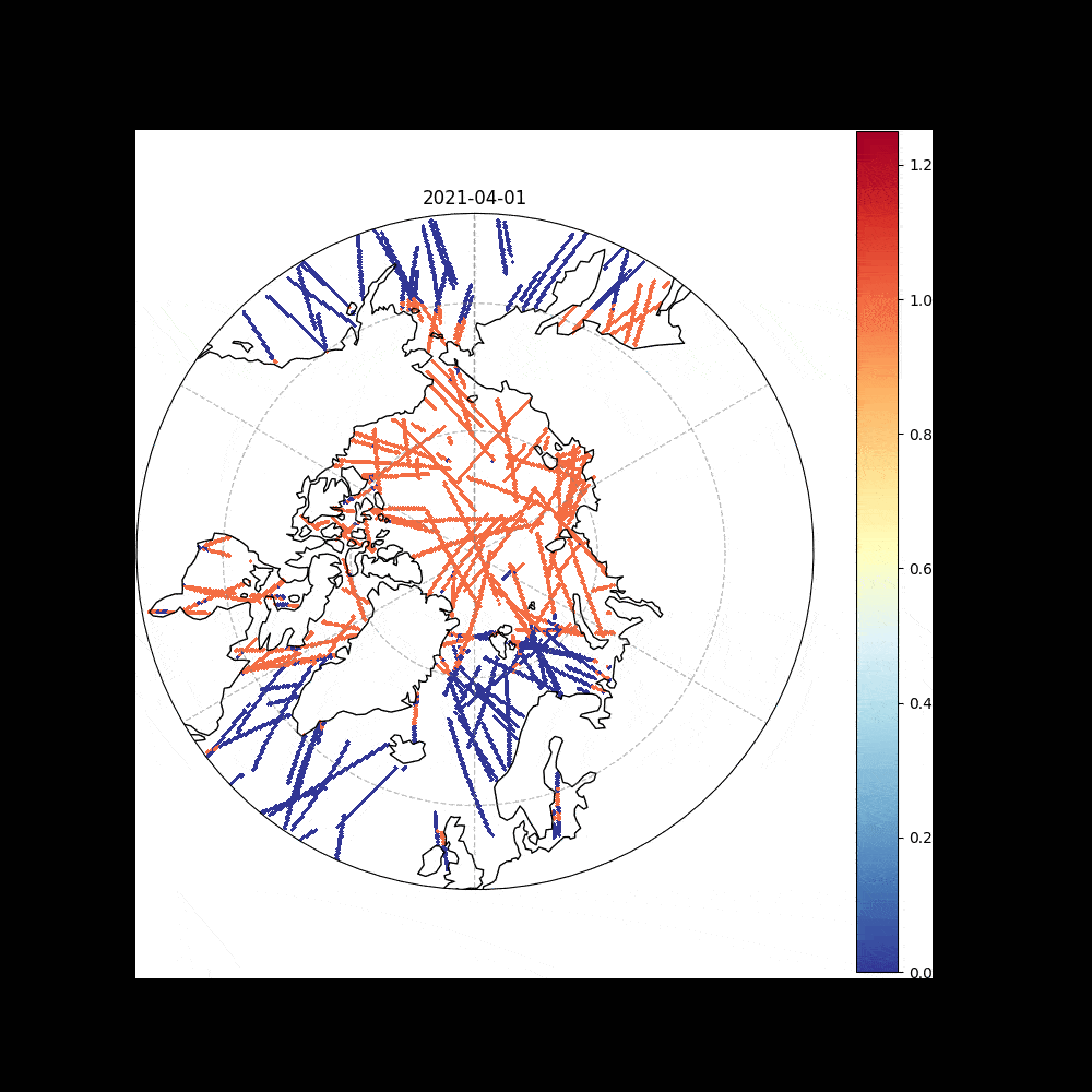
Spire Ice Detection from Grazing Angle GNSS-R in the Arctic, data from April 2021, gridded at 5 km resolution.
Spire’s sea ice extent measurements have the capability to distinguish sea ice from open water in order to map sea ice coverage. This also allows us to delineate the marginal ice zone (MIZ), which is a transitional region between open sea and dense drift ice.
SEA ICE CLASSIFICATION
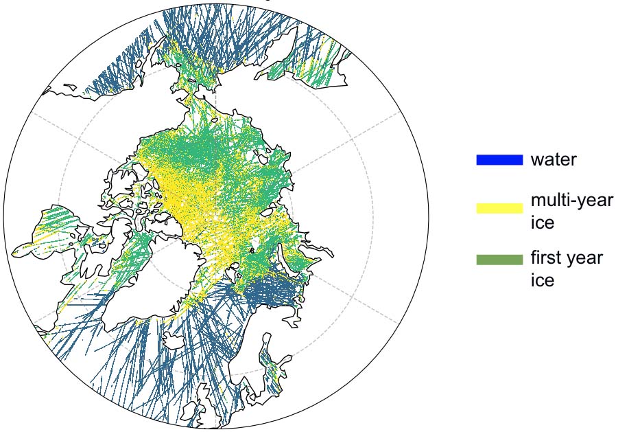
Spire Ice Type Classification from Grazing Angle GNSS-R in the Arctic, data from March 2020, gridded at 5 km resolution.
Spire’s sea ice classification measurements allow for the categorization of ice type, i.e. age of the ice.
As climate related opportunities and challenges arise in the Arctic and Antarctic regions, abundant and accurate insights on sea ice, sea surface temperatures, and weather patterns will be critical. Spire can deliver this data with refined accuracy and abundance.
Researchers can access our unique Arctic data now. In 2020, Spire received a contract award for commercial operational earth observation data from NASA under the Commercial Smallsat Data Acquisition (CSDA) Program. Through this contract, we provide GNSS-RO atmospheric profiles, space weather measurements, grazing angle reflectometry used in sea ice measurements, and more. Spire’s contract with NASA was renewed in May 2021, and this data is currently available to support environmental research efforts.
Supporting security missions in the Arctic and Antarctic regions
The 2013 DoD Arctic Strategy lays out a framework for the United States to harmonize human and environmental security, highlighting myriad activities in the region such as resource extraction, trade, promoting safe scientific and commercial activities, and national defense, but other countries are also exploring what opportunities the changing climate may bring. Russia, for example, has developed its Northern Sea Route, which the Russian Energy Ministry promoted as comparatively more “reliable, secure, and competitive” during the Suez Canal jam.
Additionally, the United States risks falling behind other countries in regards to icebreaker ship development and deployment. As the U.S., Russia, China, Norway and Finland, among many other nations, continue to increase their presence in the region, critical Arctic data is needed to anticipate world power convergence in search of oil, natural gas, and other strategic advantages.
In The Art of War, Sun Tzu lists Heaven (the weather) and Earth (the terrain) as two of the five main considerations to achieve battle-less victory. Spire’s data can help the U.S. national security community master the weather and terrain in the Arctic and achieve national security goals while promoting U.S. superiority both in space and the Arctic. Spire’s combined weather forecasting and AIS data provide strong support for mastering the weather and terrain for security operations.
Our sea ice data measure the extent, classification, and age of sea ice, and our GNSS-R sensors measure ocean surface height, roughness, wind speed, surface water mapping, and soil freezing and thawing. Spire’s weather forecast bundle offers wind data, incredibly precise weather data for obscure locations, wave height, and maritime waves. We also provide insights on space weather, including Northern Lights, comms and navigation, and temperature.
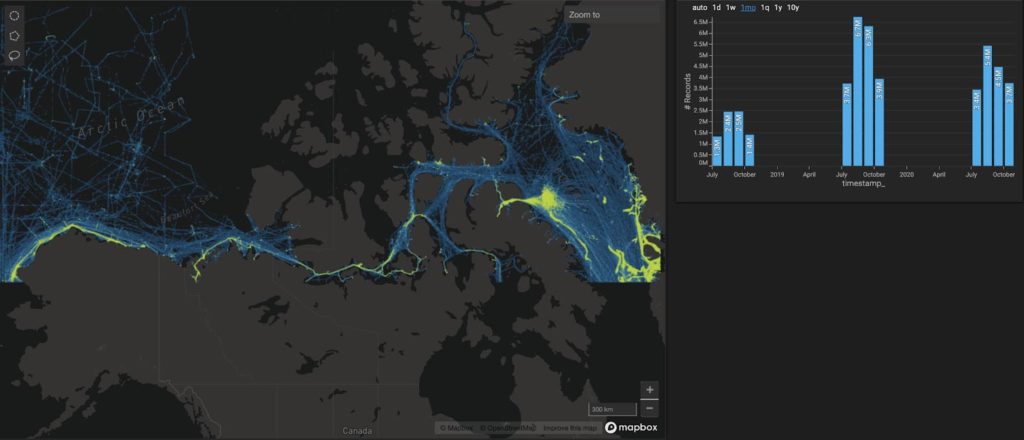
Spire can also provide national security customers with vessel tracking capabilities in the Arctic through our high-quality satellite, terrestrial, and Dynamic™ AIS data. Spire collects AIS signals from over 200,000 vessels around the Earth and processes these signals into AIS messages to provide real-time vessel tracking data through our API.
Furthermore, Spire maintains extraordinary coverage in high traffic zones (HTZs) such as the North Sea, where the density of vessels is extremely high, and AIS coverage is notoriously lacking. We created a solution addressing the HTZ problem by adding +2,100 dynamically moving AIS receiving stations on vessels throughout all major sea routes and HTZ areas, collecting this data and updating it via communications satellites every 15 minutes. This results in an additional total volume of 10M AIS messages per day and an average 135,000 unique MMSIs per day globally.
Spire is prepared to support the Department of Defense and Department of Homeland Security as their Arctic presence becomes increasingly necessary, being able to provide them with masterful data that gives our warfighters greater confidence in operating in remote areas with uncertain conditions. Our polar focused constellation of CubeSats is increasing maritime intelligence in the Arctic while providing critical weather insights to support remote operations around the world.
Accurate data means Arctic and Antarctic superiority
Spire offers comprehensive data and weather forecasting services to provide an all-in-one data solution to both civilian and military agencies to promote and protect U.S. interests in the Arctic and Antarctic regions. As great-power competition continues to ramp up in the Arctic and the region becomes more crowded, it is imperative that researchers and service members have access to the most accurate and comprehensive data available.
Spire can provide this mission critical data in real-time with a tried and tested space-to-cloud data and analytics infrastructure, leveraging small satellites to solve Earth’s biggest problems.