Taking the Battle to Space: Detecting & Geolocating GPS Jamming Signals
 Written by
Janie Yurechko
Senior Product Marketing Manager at Spire Federal
Discover Spire’s approach to detecting and geolocating GPS jamming and spoofing signals
Spire has been monitoring the proliferation of space and cyber weapons as well as researching technological developments to help protect U.S. space superiority and assets. GPS jamming and spoofing is on the rise around the world, and our detection and developing geolocation capabilities can support U.S. information dominance and promote peace by helping to maintain the global balance of power with space technology.
Suspicious signals: Seek and we shall find
The prevalence of GPS jamming in conflict zones has increased dramatically in recent years, with evidence of effective jamming of U.S. aircraft in Syria, North Korea, and other countries. It is becoming increasingly important to U.S. military interests to effectively detect and locate sources of GPS jamming and spoofing to ensure warfighter safety.
Jamming happens when an intentionally produced radio frequency (RF) signal blocks a true satellite signal so the receiver no longer operates, preventing the transmission of critical data. Spoofing happens when an RF signal mimics a true signal, causing the signal to display false information. GPS technology has been vulnerable to jamming and spoofing for years due to the weak signal from GPS satellites.
The jamming and spoofing problem
GPS signals can be jammed or spoofed relatively easily and for low cost, and methods are evolving. For example, truckers across the U.S. can purchase $10 GPS jammers to prevent their employers from tracking their movements. USAF F-35s in Israeli airspace experienced jamming from an air base in Syria in 2019. North Atlantic Treaty Organization (NATO) military drills consisting of 40,000 troops from all 29 member states in the Baltic Sea also experienced jamming.
The Center for Advanced Defense (C4ADS) studies analyzed automatic identification system (AIS) data and discovered that hundreds of vessels were spoofed while navigating the Huangpu River in Shanghai. Conventional spoofing can be overt (jam-then-spoof strategy in which the false signal is broadcast at a significantly higher power level than the authentic signal) or covert (the counterfeit signal is aligned with the true signal and its power level is increased to overtake the true signal). In the Shanghai spoofing incidents, GPS signals were congregated into large circles called “crop circles” that created confusion in maritime traffic.

Above: Anomalous AIS Activity Clusters Near Chinese Coast
Cutting edge technology and research for GPS jamming detection and geolocation solutions
Spire’s growing constellation of CubeSats carries flexible, software-defined radios that can be harnessed for detecting and geolocating signals of interest.
Most existing methods offer ground or wifi-based PNT solutions that are effective in preventing jamming and spoofing techniques due to the powerful signals they put out. Spire has actively researched and tested our capabilities based on a low-Earth orbit (LEO) constellation of nanosatellites, with recent success in detecting cooperative GPS jamming signals validated by our customers.
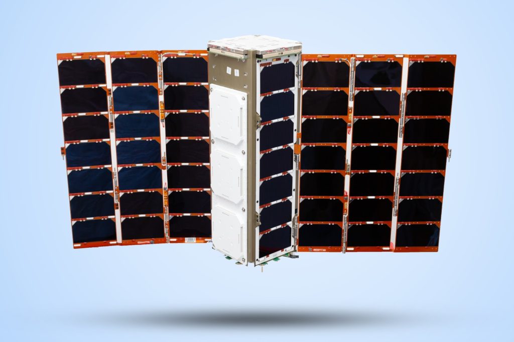
Spire 3U GNSS-RO satellite
The Spire GNSS reflectometry (GNSS-R) instrument – used to study GNSS signals that are reflected or scattered by the Earth’s surface – is a flexible SDR receiver mated with two high-gain nadir-oriented L-band antennas that can capture both raw recordings and make precise measurements of GNSS signals emanating from the Earth’s surface. Additionally, the zenith L-band antenna is dual-frequency (L1/L2), allowing for precise positioning of Spire satellites. Consequently, variants of the Spire GNSS-R satellites are well-suited to detect and geolocate GNSS jammer sources.
 Spire GNSS-R Batch 2 satellite
Spire can extend the capability of its GNSS-R payload to detect GPS jammers and leverage our LEMURs in flying formation to geolocate the emissions. Spire is actively studying and preparing to demonstrate on-orbit GPS jammer detection in multi and single satellite receiving scenarios.
A study on LEO orbit GNSS interference monitoring found that multi-satellite and single satellite interference monitoring were effective for accurately detecting and tracking GNSS signals. The multi-satellite geolocation approach involves two LEO satellites flying in parallel formation. A suite of other geolocation techniques can be readily used when there are three or more satellites. Spire is currently applying state-of-the-art hybrid time difference of arrival (TDOA) and frequency difference of arrival (FDOA) approaches to provide RF geolocation when multiple satellites have simultaneously received the signal-of-interest.
The single satellite approach uses only Doppler-based measurements to converge on an unambiguous geolocation solution. The single satellite approach is inherently more difficult, but it is a more cost-effective and infrastructure-friendly alternative to the multi-satellite approach. Spire geolocation experts have devised ways to improve accuracy and mitigate risks presented from single satellite geolocation.
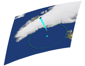
A standard scenario for RF Emitter Geolocation. The red dot is the emitter while the satellite moves overhead in black. The sub-satellite path and range vectors are in cyan while the antenna footprints are also shown at time zero (black dots) and five seconds later (light green dots).
Spire’s RF geolocation expert, Dr. Patrick Ellis, published a recent paper illustrating an experimental passive geolocation solution for a single satellite to perform in single-pass, single transmission, short duration scenarios that are computationally feasible to accommodate real-time processing. The technique involves a two step RF emitter geolocation processing chain that estimates Doppler and Doppler Rate and then maps these measurements to an unknown emitter location utilizing a nonlinear filtering approach. Adaptation of this single satellite approach for geolocating GPS jammers is ongoing.
Spire successfully detects threat signals with GNSS-RO satellites
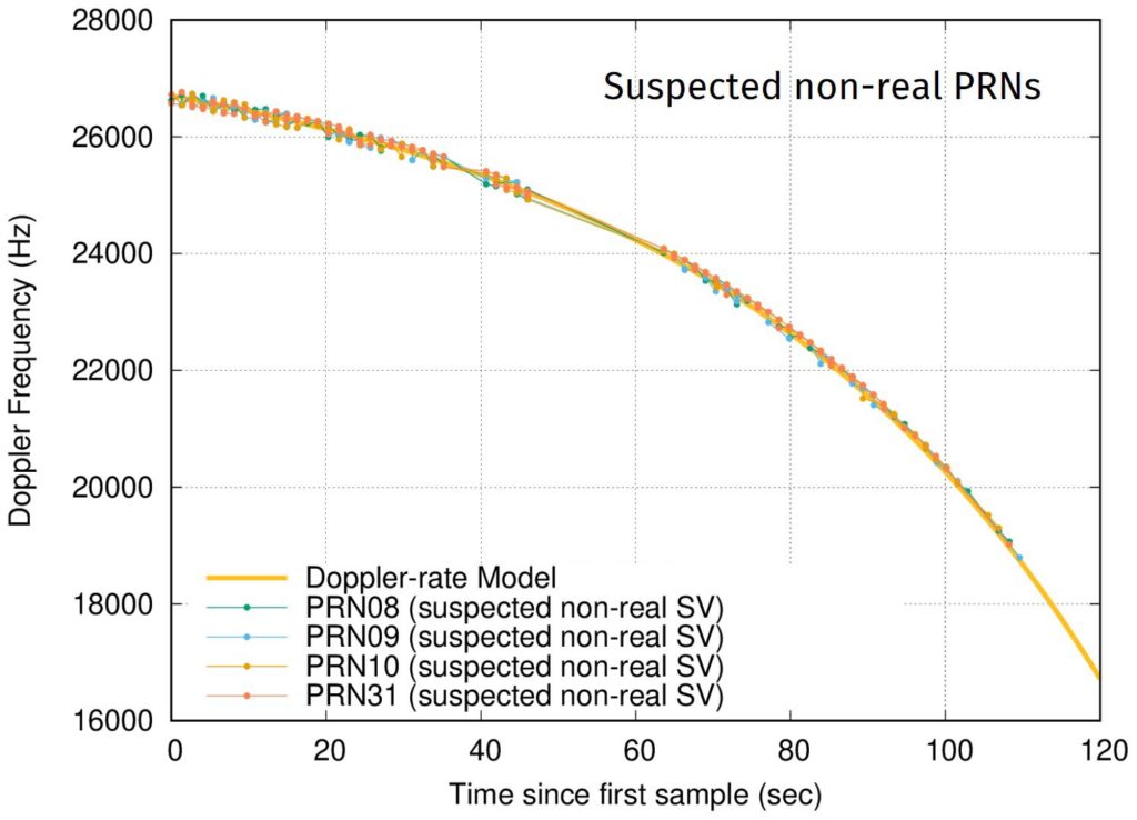
In April, and on just a few days notice, Spire successfully leveraged a multi-satellite capability demonstration for a U.S. government customer. Three GNSS radio occultation (RO) satellites were tasked to collect raw Intermediate Frequency (IF) data during active jamming tests at a location within the continental U.S. The antenna polarization and orientation of Spire’s 3U RO CubeSats proved to be suitable for detecting signals from certain GPS jammers. After initial analysis, the customer validated that Spire detected the jammer using our GNSS-RO satellites.
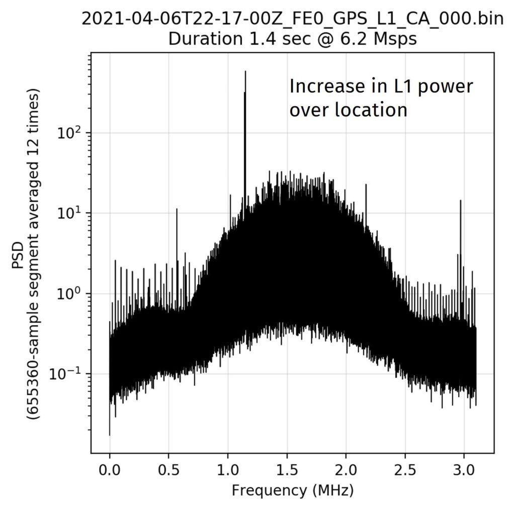
At least two satellite passes were aligned spatially and temporally to observe the active jammer, and the satellites were rapidly tasked to collect raw IF data. The first set of downloaded data showed a distinct increase in spectral activity in the GPS L1 band. Upon further analysis, the expected real PRN signals and evidence of false PRN broadcasts were shown. The observed Doppler of all false PRNs matched the expected Doppler characteristics of a jammer located at the designated test location. Spire concluded and the customer validated that the collected signals were, indeed, the jamming signals from the designated test location. Spire’s first GPS jamming detection test was successful.
Spire has proven our ability to detect GPS jamming signals. The next step is to successfully geolocate the point of origin utilizing the techniques discussed earlier. Spire has already launched and is operating over 40 geolocation-capable satellites providing us with an edge over other providers in this space that are still in early R&D stages. We are confident that our constellation can provide reliable, accurate, and cost-effective geolocation and interference monitoring services to the defense community.
Dominating the battlespace with CubeSats
Spire’s LEO nanosatellite constellation is poised to provide GNSS jamming detection and geolocation in terms of price, signal strength, accuracy, and coverage. Spire’s LEMUR-2 3U CubeSat bus is proven and ready.
GPS jamming and spoofing geolocation is a mission critical capability that puts adversaries on notice and encourages trust between warfighters and modern technology, especially artificial intelligence. As Spire expands our payload offerings, tests our capabilities with new use cases, and reimagines what it means to operate in space, we will focus our innovative efforts on solving the next big problem with small satellites.