Validating Spire’s Soil Moisture product: A preview of the data behind the insights
 Written by
Spire Global
Understanding and monitoring soil moisture is crucial across a wide range of industries, from precision agriculture to wildfire mitigation, environmental monitoring, and climate science.
At Spire, we’ve developed a cutting-edge global soil moisture measurement and insights system designed to deliver consistent, high-resolution data across diverse landscapes and climatic conditions. As we prepare for the release of our full validation whitepaper later this year, we’re excited to share a first look at how our product performs against trusted ground truth data.
Why validation matters
Satellite-based soil moisture products only deliver value when they reliably capture the key spatial and temporal variability that drives operational decision-making. To ensure our data meets the demands of decision-makers in the field, we’ve conducted a validation campaign using in-situ soil moisture measurements from a wide range of monitoring networks.
These ground-based measurements serve as a critical benchmark, allowing us to assess the performance of our retrieval algorithms across different soil types, vegetation covers, and weather conditions.
Our validation approach
We compared our satellite-derived soil moisture data against in-situ data from several well-established monitoring networks, including:
- COSMOS-UK
- TERENO in Germany
- USCRN in North America
The validation campaign covered a variety of geographic regions and climate zones, providing a robust assessment of the product performance under different environmental conditions.
Key results
In this section, we present two sets of results: (1) spatial maps of Spire’s 500-meter soil moisture product (D-ESSM) over the United Kingdom for January, April, July, and October 2020, alongside the locations of in-situ measurement sites from the COSMOS-UK network; and (2) six time series plots comparing Spire’s D-ESSM data with in-situ soil moisture observations from multiple stations.
D-ESSM
500-meter soil moisture over the United Kingdom
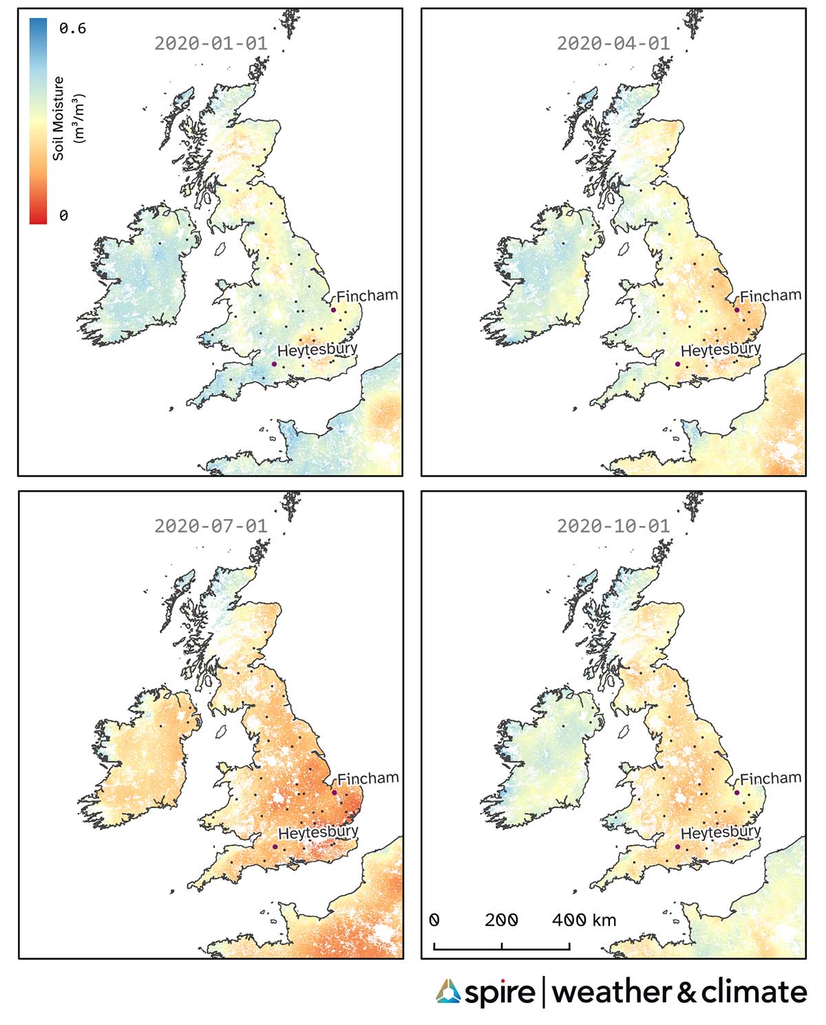
Figure 1. Spire D-ESSM over the UK for four dates in 2020, with placement of COSMOS-UK measurement network (black dots). Fincham and Heytesbury stations are highlighted (purple dots) as the locations of the validations below.
The following plots display daily soil moisture values, where Spire’s D-ESSM data (red circles, solid line) is compared against in-situ observations at 5 cm depth (grey x-marks, dashed line). This period spans over two full seasonal cycles, capturing the natural variability in soil moisture. The inset box reports key validation metrics, including bias, correlation coefficient (Corr), root mean square error (RMSE), and mean absolute error (MAE), which quantify the agreement between the datasets.
COSMOS-UK STATIONS
ESA CCI Landcover: Cropland, rainfed
Climate: Temperate Without Dry Season, Warm Summer
In-situ Instrument: TDT, Depth from 0.05 to 0.05 [m]
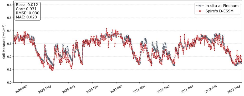
Figure 2. Comparison of Spire’s 500-meter soil moisture product (D-ESSM) with in-situ measurements at Fincham (UK station), from January 2020 to June 2022.
ESA CCI Landcover: Grassland
Climate: Temperate Without Dry Season, Warm Summer
In-situ Instrument: TDT, Depth from 0.05 to 0.05 [m]
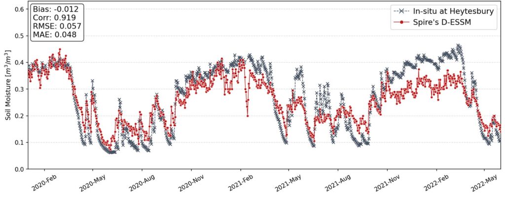
Figure 3. Comparison of Spire’s 500-meter soil moisture product (D-ESSM) with in-situ measurements at Heytesbury (UK station), from January 2020 to June 2022.
TERENO STATIONS
ESA CCI Landcover: Cropland, rainfed
Climate: Temperate Without Dry Season, Warm Summer
In-situ Instrument: Hydraprobe-II-Sdi-12, Depth from 0.05 to 0.05 [m]
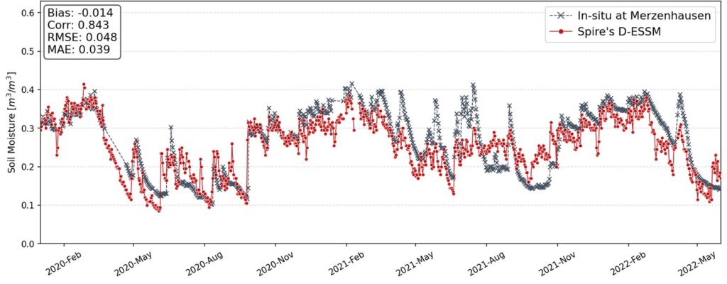
Figure 4. Comparison of Spire’s 500-meter soil moisture product (D-ESSM) with in-situ measurements at Merzenhausen (station in Germany), from January 2020 to June 2022.
ESA CCI Landcover: Tree cover, needleleaved, evergreen, closed to open (>15%)
Climate: Temperate Without Dry Season, Warm Summer
In-situ Instrument: Hydraprobe-II-Sdi-12, Depth from 0.05 to 0.05 [m]
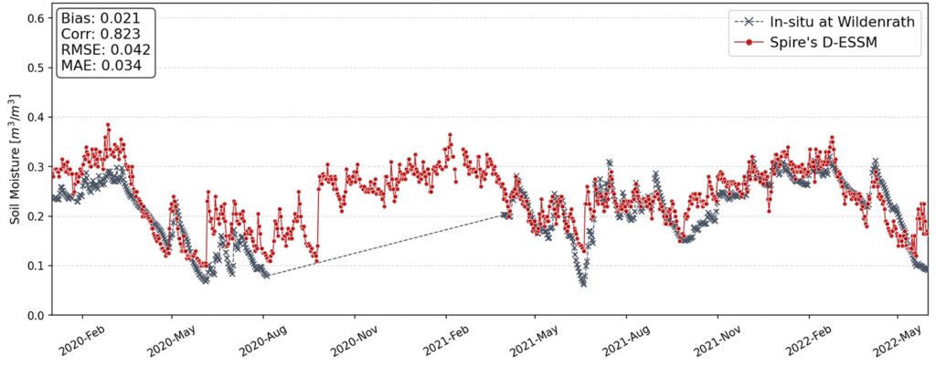
Figure 5. Comparison of Spire’s 500-meter soil moisture product (D-ESSM) with in-situ measurements at Wildenrath (station in Germany), from January 2020 to June 2022. The in-situ measurements have a gap of more than 8 consecutive months starting from August 2020.
USCRN STATIONS
ESA CCI Landcover: Tree cover, broadleaved, deciduous, Closed (>40%)
Climate: Temperate Without Dry Season, Hot Summer
In-situ Instrument: Stevens-Hydraprobe-lII-Sdi-12, Depth from 0.05 to 0.05 [m]
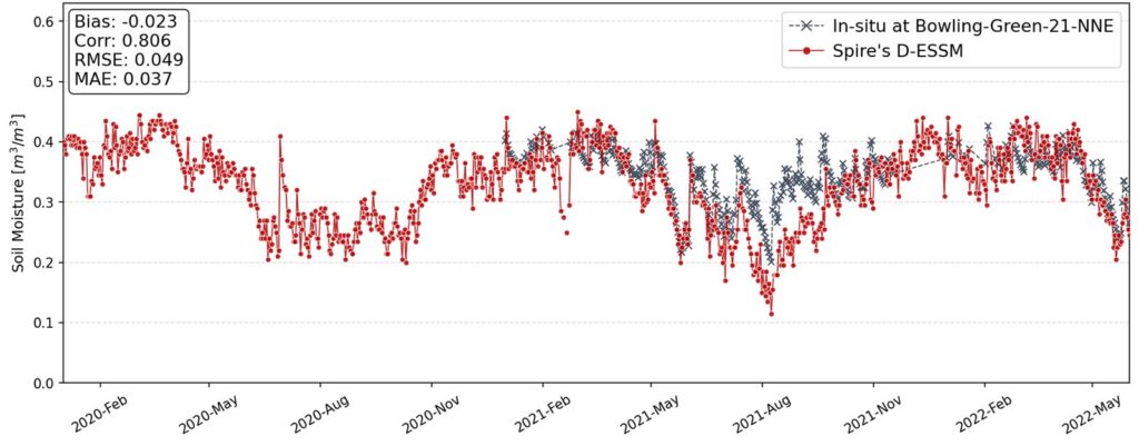
Figure 6. Comparison of Spire’s 500-meter soil moisture product (D-ESSM) with in-situ measurements at Bowling-Green-21-NNE (station in US), from January 2020 to June 2022. The in-situ measurements have a gap of 12 consecutive months from January 2020.
ESA CCI Landcover: Mosaic herbaceous cover (>50%) / tree and shrub (<50%)
Climate: Temperate Without Dry Season, Hot Summer
In-situ Instrument: Stevens-Hydraprobe-lII-Sdi-12, Depth from 0.05 to 0.05 [m]
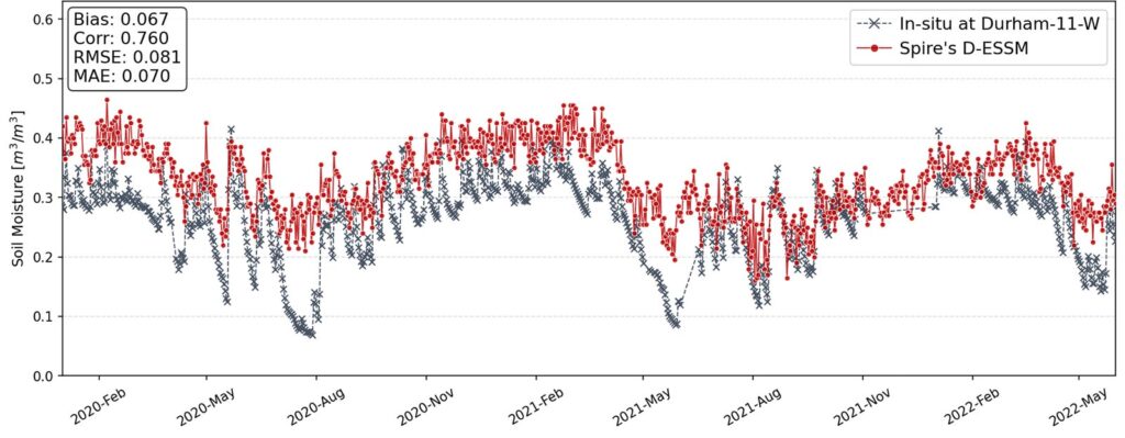
Figure 7. Comparison of Spire’s 500-meter soil moisture product (D-ESSM) with in-situ measurements at Durham-11-W (station in US), from January 2020 to June 2022.
Summary of results:
Our results show the accuracy and reliability of our soil moisture estimates. Here are a few highlights:
- High correlation with in-situ data: Across all validation sites, we observe correlation coefficients ranging from 0.7 to 0.94, depending on soil depth and site characteristics.
- Low bias and error: Root Mean Square Error (RMSE) values were consistently within 10% of the mean observed soil moisture, with minimal bias across seasons.
- Continuous, gap-filled coverage and consistent data: Unlike in-situ networks, which often suffer from data gaps and outages, our satellite-derived product delivers continuous, spatially and temporally complete soil moisture data, ensuring reliable insights even in regions with limited ground instrumentation.
What’s next?
Our upcoming whitepaper will dive deeper into:
- Validation methodologies (including temporal and spatial matching techniques)
- Breakdown of performance by biome, season, and land use
- Comparison with other existing soil moisture products
- Case studies showcasing real-world applications
Final thoughts
By combining data from L-band radiometers, GNSS-R, and SAR sensors, we deliver a soil moisture product that is both scientifically robust and enables critical, timely decision making for our customers. These sensors differ significantly in terms of revisit frequency, spatial resolution, and sensitivity to soil moisture which our proprietary AI-based algorithms take advantage of to produce high-resolution soil moisture data with daily updates.
Stay tuned for the full whitepaper later this year.
Put data-backed insights to work
Get in touch to explore how Spire’s high-resolution soil moisture data can support your operations. Ready to explore the data?
It’s important to note that we do not expect a perfect match between satellite-derived soil moisture and in-situ measurements. In-situ sensors measure soil moisture at a single point, typically at a fixed depth and location, and are often influenced by highly localized factors such as soil heterogeneity, vegetation cover, microtopography, and even sensor installation or maintenance issues.
In contrast, satellite-based products represent an area-average over a broader footprint (in our case, 500 meters), and integrate signals from the surface layer across that area. As a result, some level of discrepancy is natural and expected. Rather than seeking exact one-to-one correspondence, validation efforts focus on statistical agreement and overall consistency across time and space, which provide more meaningful indicators of product quality and utility. Comparisons with traditional sources give equivalency in customer workflows and demonstrate utility for application.