Beyond the rainfall: How soil moisture tipping points drove China’s 2025 flood disaster
Meghan Mussoline
Product Marketing Manager, Spire Weather and Climate
Using satellite soil moisture validation to uncover how saturated soils amplified China’s July 2025 flood disaster.
Soil moisture validation executive summary
Between July 23rd and August 1st, 2025, Northern China (Hebei province and Beijing municipality) experienced record-breaking precipitation, with some districts receiving more than a year’s worth of rainfall in just a matter of hours. Saturated soils and continuous storms triggered cascading hazards, including flash floods, landslides, and reservoir stress. Impacts included more than 70 fatalities, tens of thousands displaced, and inflows at Beijing’s Miyun Reservoir reaching the highest levels since records began.
The scale and speed of the disaster were well documented in open-source reporting, providing a clear timeline of events that Spire data validates in this report.
Timeline & summary of events
- July 25, 2025: Initial storms dumped nearly a year’s worth of rain on Baoding; Beijing issued flood alerts.
- July 26, 2025: Geological disaster warnings; Fuping County recorded up to 145 mm/hour, totaling 540 mm in 8 hours.
- July 27, 2025: Reports of fatalities and thousands
- July 28, 2025: Flooding and landslides in Miyun and Yanqing; 34 deaths, 80,000 relocated; Miyun Reservoir inflows peaked at 6,550 m³/s.
- August 1, 2025: Week-long totals exceeded 543 mm in Miyun; national toll above 70
Extreme rainfall & flood report timeline
July 25, 2025 (Baoding, China)
On July 25th, 2025, northern China was hit by torrential storms, with Baoding (Hebei province) receiving nearly a year’s worth of precipitation in just a single day. In the Yi district of northwest Baoding, more than 448 mm fell within 24 hours, flooding streets, cutting power in villages, and damaging bridges and roads. The surge forced the evacuation of more than 19,000 residents across six townships.
In Zhuozhou, just east of Baoding, precipitation surpassed 190 mm by Friday morning, disrupting access to bridges and highways in a city that had already suffered severe flooding in 2023. Authorities in Baoding issued a “red alert” for heavy rain, while Hebei province elevated its emergency response posture in preparation for the storms.
Further north in Beijing, roughly 160 kilometers from Baoding, flash flood alerts were issued for four of its districts after forecasts projected more than 50 mm of rain between the afternoon of July 25th and the morning of July 26th. Officials warned of rising stormwater and landslide risk in the capital’s mountainous northern and western districts.
The storms also affected transport infrastructure beyond Hebei and Beijing, including Inner Mongolia, where rail services were suspended along numerous high-risk routes from July 25th to July 29th.
July 26, 2025 (Fuping, China)
On July 26, 2025, Beijing issued geological disaster warnings for ten of its sixteen districts, citing heightened risks of landslides and mudslides following consecutive days of torrential downpours. The alerts came as storms again swept through Hebei province, where Fuping County in Baoding recorded some of the most intense rainfall of the event.
At the Xizhuang weather station, precipitation peaked at 145 mm in a single hour, while totals reached 540 mm in just eight hours – surpassing Baoding’s average annual of around 500 mm.
The rainfall affected more than 46,000 residents in Fuping, with at least 4,655 people forced to evacuate. Flash floods and saturated slopes cut access across mountainous terrain, while state media highlighted the destructive force of the water that, in just two days, had matched or exceeded annual averages across different districts of Baoding.
National authorities extended flood warnings to eleven provinces, including Beijing and Hebei, warning of surging torrents in small and medium rivers and the need to ensure the safety of reservoirs and silt dams. Across northern China, cumulative precipitation pushed thirteen rivers in seven provinces beyond flood warning levels by as much as 1.4 meters.
In Inner Mongolia and Shaanxi, tributaries of the Dahei and Yanhe rivers registered their largest floods on record, while in northeastern Jilin province, two small reservoirs were operating above capacity, and five larger dams were activated to discharge water.
The storms reinforced a broader monsoon-driven pattern of extreme weather that has repeatedly tested China’s ageing flood defenses and threatened widespread disruption to infrastructure and local communities.
July 27, 2025 (Regional-Northern China)
On July 27, 2025, the flooding turned deadly as authorities confirmed the first fatalities of the event. State broadcaster CCTV reported that two people were killed and two others were missing in Hebei province, while thousands more residents were forced to relocate.
In Beijing’s Miyun district, floods and landslides struck rural towns, including Fengjiayu, where electricity and communications were cut and more than 3,000 residents were evacuated. The Miyun Reservoir reached record inflows of 6,550 cubic meters per second – pushing the capital’s main water supply system to its limits.
Forecasts warned that rainfall across Beijing’s northern districts could exceed 100 mm in six hours, raising the risk of additional slope failures and flash flooding in low-lying areas.
At the national level, the Water Resources Ministry expanded flood warnings across 11 provinces and regions, including Beijing, Hebei, Inner Mongolia, and Shaanxi. Officials highlighted the dangers of torrents in smaller rivers and stressed the need for close monitoring of dams and reservoirs.
Thirteen rivers across seven provinces were already reported above their flood thresholds, underscoring the systemic pressure the monsoon-driven storms were placing on China’s flood defenses and infrastructure.
July 28, 2025 (Miyun, China)
On July 28, 2025, the disaster deepened as heavy rain triggered a landslide in northern Hebei province, killing four people and leaving eight others missing. Authorities relocated more than 4,400 residents in Beijing’s Miyun district as flash floods and slope failures inundated rural villages. Images circulated on Chinese social media showed cars floating on submerged roads and floodwaters reaching the lower levels of residential buildings.
Electricity outages affected more than 10,000 people across the district, while officials confirmed that Xiwanzi Village in Shicheng Town had been severely hit, forcing an additional 100 villagers into emergency shelters.
The crisis placed renewed stress on the capital’s water infrastructure. After already reaching record inflows the previous day, the Miyun Reservoir continued to operate at peak levels of 6,550 cubic meters per second, straining dam capacity and prompting Beijing to issue its highest-level flood alert.
In Pinggu District, two high-risk road sections were closed due to slope instability, and across Shanxi and Shaanxi provinces, flash flood warnings were raised as rivers burst their banks and roads were swept by torrents.
National authorities expanded disaster relief measures. The National Development and Reform Commission allocated 50 million yuan (US$6.98 million) for recovery efforts in Hebei, targeting the repair of damaged roads, bridges, embankments, schools, and hospitals. Search and rescue operations were underway across multiple provinces, including Datong, where a driver went missing during the floods.
August 1, 2025 (Northern China, Regional)
By August 1, the cumulative toll of the flooding across Beijing and Hebei had risen sharply, with authorities confirming more than 70 deaths nationwide and dozens still missing.
In Beijing, the toll reached 44 fatalities, including 31 elderly residents who drowned after floodwaters from the Qingshui River engulfed a care facility in Taishitun, Miyun district. Nearly 80 people were trapped inside; while 48 were rescued, officials later acknowledged serious lapses in preparedness and evacuation planning for vulnerable populations.
Relief and recovery operations scaled up across the region. In Beijing, more than 104,000 residents were evacuated, over 300,000 people were affected citywide, and 24,000 homes sustained damage. The hardest-hit districts included Miyun, Yanqing, Huairou, and Pinggu. A joint civil-military command mobilized 6,000 soldiers and firefighters, backed by heavy machinery, to clear debris, reinforce embankments, and reopen blocked transport routes. By August 1, 364 of 424 rural roads were restored, and all cut-off villages had access to emergency water supplies.
At a press briefing, Beijing’s Executive Vice Mayor Xia Linmao described the floods as “one of the most severe natural disasters in decades.” Officials observed a moment of silence for the victims, while pledging stronger protections for the elderly, children, and other vulnerable groups, and committing to improving forecasting, early warning systems, and disaster planning for future events.
Spire soil moisture validation
July 25, 2025 (Baoding, Yi District, China)
Spire’s near-real-time soil moisture data captured the rapid transition from normal conditions to full saturation during the extreme rainfall in Baoding. The sequence below (July 23–25) illustrates how soils in Yi District shifted from baseline levels to extreme wetness in under 48 hours, following the reported 448 mm of rainfall by local Chinese outlets.
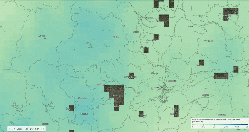
Soil Moisture Insights (6 km) in Baoding/Yi District, China for July 23, 2025 through July 26, 2025
Prior to the heavy rainfall, soil moisture levels across Baoding and the Yi District remained relatively stable, according to Spire’s daily updates on July 23 through July 25, with values hovering around 0.20 m³/m³ in most areas. Fields and river basins appeared within the normal seasonal range for late July, indicating that the ground was not unusually saturated in the days leading up to the storm. In other words, the soil still had plenty of capacity to absorb water.
By July 26, following reports of 448 mm of rainfall in under 24 hours, Spire’s near-real-time soil moisture data captured a dramatic shift. Values surged across Yi District, with localized cells showing >0.40 m³/m³, nearly double the levels from just two days earlier. This anomaly corresponds directly to the reported rainfall intensity and helps showcase how quickly the land transitioned from normal to flood-prone saturation.
In short, Spire’s soil moisture record not only validates the extreme rainfall totals reported in Baoding but also reveals the hydrological tipping point that turned heavy rain into a cascading flood hazard. The near-real-time spike made it clear that soils had lost their buffering capacity, ultimately amplifying runoff and increasing infrastructure risk.
This perspective goes beyond open-source rainfall reports, demonstrating how Spire’s data captures the land-surface response that ultimately drives disaster impacts.
July 26, 2025 (Fuping, China)
Spire’s anomaly data highlights just how exceptional the Fuping rainfall event was compared to the region’s long-term climatology.
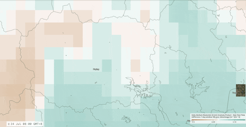
Spire’s Soil Moisture Insights Anomaly maps (6 km) from July 24, 2025 to July 28, 2025 show soils transforming from neutral to drier than average to saturated as the flooding rainfall event unfolded.
On July 24, soil moisture anomalies across Fuping were primarily neutral to slightly negative, reflecting drier-than-average conditions leading up to the storm. Fields and slopes still had significant absorption capacity, a typical baseline for late July in central Hebei.
By July 25 into July 26, as storms intensified, localized anomalies began shifting positive, though much of the county remained within historical variability. This transitional state is consistent with reports of heavy overnight rainfall, but it shows that the soils had not yet reached total saturation across the basin.
After intense precipitation on July 26, the soil moisture anomalies showed a dramatic swing by July 27. Soil moisture values surged well above the 30-year baseline, with anomalies exceeding +0.18 m³/m³ in multiple cells around Fuping. This confirms that the county not only absorbed extraordinary rainfall but also quickly crossed into unprecedented saturation territory.
Spire’s validation demonstrates that the July 26 floods were not simply a function of short-term downpours but a departure from decades of climatological norms. The near-real-time anomaly signal highlights how soils transitioned from dry-to-average moisture into record wetness in less than 48 hours, amplifying slope instability and flash flood potential across mountainous terrain.
July 27, 2025 (Miyun District / Miyun Reservoir, China)
Spire’s near-real-time soil moisture data captured the rapid escalation of saturation across the Miyun basin as inflows surged into Beijing’s primary reservoir. The sequence below (July 25–27) illustrates how soils in the upstream catchment transitioned from moderately wet to fully saturated in under 48 hours, aligning with official reports of inflows peaking at 6,550 m³/s.
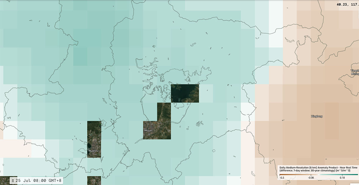
July 25, 2025: Historical context for soil moisture anomalies in Miyun District, China
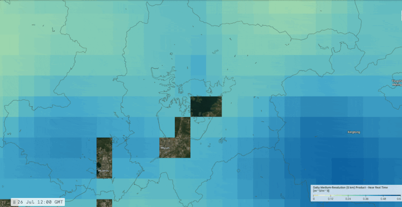
Soil Moisture Insights (6 km) in Miyun District, China for July 26, 2025 through July 29, 2025
On July 25, soil moisture anomalies around Miyun and its northern catchments remained near seasonal norms, ranging from 0–0.12 m³/m³. Despite several days of rainfall, the watershed still held limited buffering capacity, indicating that the basin had not yet tipped into full saturation.
By July 26, soil moisture levels had risen sharply across northern Miyun and its adjacent mountain districts. Large areas exceeded 0.36 m³/m³, mirroring the surge in reported inflows at Miyun Reservoir. Localized anomalies highlight how soils were nearing full saturation, amplifying flood and landslide potential.
On July 27 into July 28, soils across the basin reached widespread saturation, with pockets registering above 0.48 m³/m³. At this stage, rainfall could no longer infiltrate the soil, converting directly into runoff and reservoir inflows.
This transition corresponds directly with eyewitness accounts of landslides, flash flooding, and record stress on the dam system.
Spire’s data validates the reported extremes while providing a crucial insight: the disaster was not only about rainfall intensity but also about soils losing their buffering capacity in real-time. This hydrological tipping point explains why Miyun’s inflows became unmanageable and why downstream flooding escalated so quickly.
July 28 – August 1, 2025 (Regional impacts across Northern China)
By July 28, the disaster had moved beyond isolated rainfall spikes to systemic impacts across Beijing and Hebei. Landslides in Miyun killed at least four people, flash floods displaced thousands, and images of submerged cars underscored the scale of the crisis. Electricity and communications were cut in multiple towns, while emergency shelters were filled with evacuees.
Spire’s soil moisture anomalies during this period remained at or above peak saturation, confirming that the land surface had lost virtually all buffering capacity. This prolonged waterlogging amplified slope
instability and sustained high inflows into Miyun Reservoir, which continued operating at record discharge levels.
By August 1, the official toll exceeded 70 deaths nationwide, including 31 elderly residents who drowned in a flooded care facility near the Qingshui River in Miyun. More than 300,000 people were affected across Beijing, with over 100,000 displaced and thousands of homes damaged. National authorities mobilized military and emergency forces for debris clearance, embankment reinforcement, and road restoration.
Final insights from Spire
Together, the open-source reports and Spire’s soil moisture record illustrate how an initial storm evolved into cascading hazards: floods, landslides, infrastructure failures, and tragic human loss. Spire’s validation highlights not only the rainfall intensity but also the sustained soil saturation that prolonged disaster conditions through the first week of August.
By pairing precipitation reports with near-real-time soil moisture validation, Spire shows not only how much rain fell but also how the land surface responded, providing deep insight that traditional rainfall data alone cannot offer.
Beyond this single event, near-real-time soil moisture data also reveal the hidden thresholds that drive disaster impacts worldwide. By tracking anomalies against decades of climatology, it becomes possible to identify when a basin transitions from stable to flood-prone, or when drought stress begins to erode resilience long before crops fail or infrastructure is compromised.
Delivered globally, with daily updates and field-scale detail, this intelligence is designed to scale across various missions, including agricultural yield forecasting, commodity trading, infrastructure risk management, humanitarian planning, and defense logistics. Combined with soil moisture forecasts, the ability to anticipate these tipping points enhances situational awareness by adding a predictive layer.
Dive deeper into Soil Moisture Insights
Spire’s soil moisture intelligence is available for exploration, including sample datasets and demos to highlight how anomaly data can inform real-time decisions.