From fields to frontlines: How soil moisture shapes military operations in Ukraine and beyond
Meghan Mussoline
Product Marketing Manager, Spire Weather and Climate
How battlefield mud, climate intelligence, and GNSS-R satellite data are reshaping military mobility in the Russia-Ukraine war.
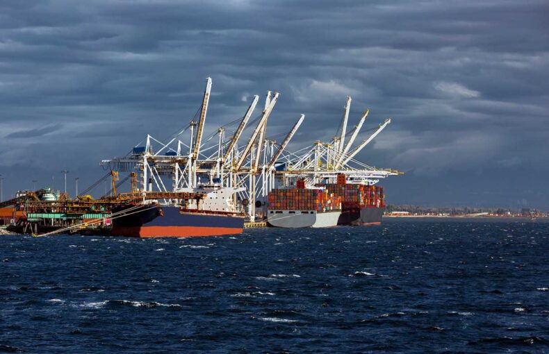
In the spring of 2025, mud once again dictated the tempo of the war in Ukraine. Weeks of rainfall across Donetsk turned fertile, black-soil fields into muddy, treacherous terrain, leaving supply trucks bogged down in mud and forcing armored vehicles onto narrow corridors of firmer ground.
Ukrainian troops described the terrain as “liquid earth”, while Russian units struggled to reinforce new defensive lines under the weight of spring rains. Far from just a nuisance, the soil itself became a decisive factor – reshaping operations and determining when mechanized assaults could move forward.
Background of seasonal conditions affecting soil moisture
From the start of Russia’s invasion of Ukraine in February 2022, weather and terrain have shaped battlefield realities, with very few factors proving more decisive than soil moisture. When Ukraine’s rich soils become saturated, they turn into deep mud that can immobilize tanks, stall convoys, and confine heavy artillery to hardened roads.
This seasonal phenomenon, known in Russia as “rasputitsa” and in Ukraine as “bezdorizhzhya”, has disrupted operations in Eastern Europe for centuries.
In both spring and autumn thaws, fields and backroads become sloppy pits of mud and water, forcing troops and equipment into narrow and often predictable corridors. For today’s mechanized military forces, these conditions translate into increased fuel consumption, higher breakdown rates, and most importantly, heightened vulnerability when mobility is constrained.
Soil moisture is not just a seasonal complication, either. It’s more accurately described as a tactical determinant. Days or weeks of heavy rainfall can quickly put the brakes on offensives, while a stretch of dry weather can unlock footpaths and accelerate advances. Both Russian and Ukrainian forces have been forced to adapt to these seasonal changes, shaping their operations as much around mud and rainfall as around enemy fire.
A string of soil moisture reporting (2022 – current)
Spring 2022: The Rasputitsa returns
One of the best examples of how rain and mud affect wartime operations came during the first months of Russia’s full-scale invasion of Ukraine. The Guardian and other outlets published images of Russian armored equipment stuck in the mud and vehicles abandoned or towed away by Ukrainian farmers.
With dirt roads and forest paths becoming impassable, convoys became easy prey for ambushes and artillery offensives, leaving paved roads as the only way forward. What was meant to be a fast-moving advance ended motionless in the mud, forcing Russian commanders to rethink their offensive strategy and pivot based on uncontrollable and hard-to-predict weather conditions.
The following year, the same seasonal cycle returned, once again bogging down both armies.
Late 2023: Mud slows operations down
In 2023, the same seasonal challenges returned. By November, both armies were once again slogging in Ukraine’s autumn mud. The War Zone, a news reporting outlet consistently covering the conflict, described how supply convoys stalled and the frontlines shifted into defensive holding patterns.
Reports from the Institute for the Study of War backed their reporting, noting that reduced maneuverability had occurred across eastern Ukraine as wetter-than-normal conditions left troops in fortified, defensive positions. For months, the battlefield was shaped less by offensive maneuver than by the environment itself.
As 2024 approached, commanders became familiar with the seasonal shifts and sought to anticipate the coming rains – launching offensives before the mud could close maneuver corridors again.
Autumn 2024: Rushed offensives before the mud strikes
Heading into fall 2024, forces looked to move before conditions deteriorated again. By early October, Russian commanders ramped up mechanized assaults in eastern Ukraine, especially across the Donetsk and Luhansk axes.
Analysts at the Institute for the Study of War noted intensified pushes toward Pokrovsk and Kurakhove, while Ukrainian spokespeople reported increased deployment of armored support to break through before seasonal rains turned the terrain into mud.
Fighting also escalated further north along the Kupiansk-Svatove-Kreminna line, a corridor already notorious for poor ground conditions that worsen sharply with autumn rainfall.
As the month wore on, these offensives collided with the realities of rasputitsa. Some battlefield descriptions conveyed that localized muddy zones in western Zaporizhzhia caused vehicles to become immobilized, with some reporting vehicles stuck so deep in the mud that they couldn’t see most of the wheels.
By winter 2025, however, the rhythm shifted once more, as frozen soils and bare landscapes reshaped the pace of operations.
Spring 2025: From slowdown to escalation
In early 2025, Russia’s offensive momentum had slowed dramatically. A Wall Street Journal analysis noted that in January, it took nearly six days to seize an area the size of Manhattan, roughly twice the pace as late 2024. Gains in February were even smaller, despite Russia sending tens of thousands of troops into areas near Pokrovsk and across Donetsk.
Several factors came together. Frozen, unstable ground limited mechanized maneuver, while leafless landscapes left Russian infantry exposed to Ukrainian drones. By late 2024, Russia had suffered hundreds of thousands of casualties, with many replacements poorly trained for the task at hand. Even mass assaults were blunted by Ukraine’s mix of artillery and drones.
The results were anything but significant. Russia captured only small towns, such as Kurakhove and Selydove, at a high cost, while the key logistics hub of Pokrovsk remained beyond reach. Analysts warned that Moscow’s armored reserves were running thin, forcing reliance on unprotected infantry and improvised vehicles.
By April, the environment began to change. Warmer weather and weeks of intermittent rainfall gave way to a steady drying of Ukraine’s topsoils. Donetsk’s fields, which were impassable in March, gradually hardened. At the same time, the first foliage returned, offering cover from overhead drones.
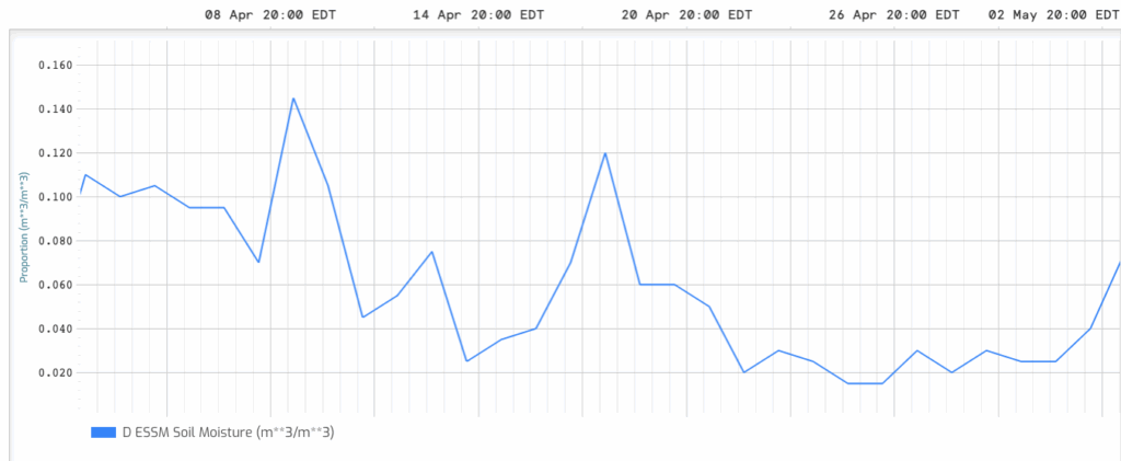
A snapshot of Spire Soil Moisture Insights time series near Kyiv, Ukraine. Soil moisture data at a 500 m resolution shows a notable drying trend throughout April 2025, punctuated by occasional upticks associated with rainfall events.
Together, these shifts altered both maneuverability and visibility.
On April 9th, Ukraine’s commander, General Oleksandr Syrskiy, warned that Russian assault operations had doubled in just a week. By mid-April, video footage captured Russian units advancing again with vehicles and infantry moving across newly hardened ground near Pokrovsk. The Wall Street Journal reported that Ukraine’s 14th Brigade stopped one such assault on April 17th, destroying dozens of vehicles.
Still, the significance of the moment was clear: after months of being slowed by mud and exposure, Russian forces were attempting to reintroduce mechanized movements into their offensives.
Ukrainian officers described the shift in stark terms.
The “liquid ground” described in March was giving way to firmer soil, opening pathways for armored vehicles that had been impassable for weeks. At the same time, the budding leaves along tree lines began to reduce the effectiveness of Ukrainian drones, making it harder to spot Russian positions and movements.
Analysts warned that these environmental shifts would gradually tilt the operational balance – not enough to guarantee breakthroughs, but enough to enable higher-tempo Russian assaults.
Spire’s data turns mud into measurable intelligence
While Ukraine’s war provides vivid examples of mud affecting regional military operations, the larger lesson is universal – the environment can dictate outcomes. The challenge is that most of these shifts have only been recognized after the fact, through on-the-ground reporting and field observation.
From March 2025 onward, Spire’s climate-anomaly data began capturing these dynamics in real time.
In Donetsk and surrounding regions, soil moisture levels rose above baseline during the March rains, aligning with reports of immobilized Russian vehicles. By mid-April, anomalies dropped back toward seasonal averages, signaling a reopening of maneuver corridors – the very window Russian forces exploited with renewed assaults near Pokrovsk.
How does Spire deliver unparalleled climate insights?
At Spire, we take a different approach to soil monitoring by listening, not just looking. Our satellites use a technique called GNSS reflectometry, which measures how GPS and other navigation signals bounce off the Earth’s surface. Because this method relies on radio waves rather than optical imagery, it works to collect data through clouds, smoke, and darkness – all of which are conditions that are nearly always present in conflict zones.
Once collected, this data is enhanced with AI and machine learning and fused with public datasets, resulting in our Soil Moisture Insights product. This dataset is updated daily with a 24-hour latency, allowing commanders to gain deeper insights into local and regional conditions.
Just as important, our data isn’t limited to simple snapshots. Instead, it’s built on a decades-long archive, which makes it possible to detect anomalies. In other words, users are able to see when the soil is much wetter or drier than the historical norm, delivering actionable intelligence at both tactical and strategic scales. Those anomalies serve as early warning signals for when routes will collapse into mud or when they will reopen and become accessible to heavy vehicles.
Accessing and applying Spire’s soil moisture insights
For analysts in the field, access comes in two ways.
- Cirrus Data Visualizer: Spire’s browser-based interface allows users to draw an area of interest, visualize time series through meteograms, and export daily maps directly into reports.
- Spire’s Weather API: The same data can be pulled programmatically, feeding straight into GIS platforms or route-risk scoring tools without human intervention.
Coverage is global, even in remote or traditionally under-covered regions, and does not require tasking. That means the same constellation tracking mud in Donetsk is also collecting over other global areas of interest at the same time. Behind it all is a scientific lineage rooted in GNSS-R and validated against ground-level truth, with performance comparable to NASA-aligned missions.
For defense planners, these insights are not theoretical. They provide an early-warning system to predict when terrain will open or close, a decisive factor in any modern conflict.
Turn Terrain into Intelligence
Discover how near-real-time soil moisture and weather data can identify mobility risks and inform operational windows.