Advanced Earth Intelligence
Access to environmental data in unprecedented detail, from Earth’s surface to near-space.
Scanning the Earth, 24/7
Spire constantly collects rich and unique data sets about our planet’s surface and its atmospheric layers to provide a complete view of what’s happening on and around Earth. Our low-orbit nanosatellites use radio frequency sensors to constantly gather new information, while predictive models distill complex environmental data into intelligent insights you can use to make business decisions, drive public initiatives, and anticipate future climate fluctuations.
![]()
What sets us apart?
True global coverage with dense spatial and temporal resolution – Spire’s large constellation, with multiple orbit planes and antennas, ensures robust global coverage, monitoring all latitudes and longitudes near-continuously from the surface to the ionosphere.

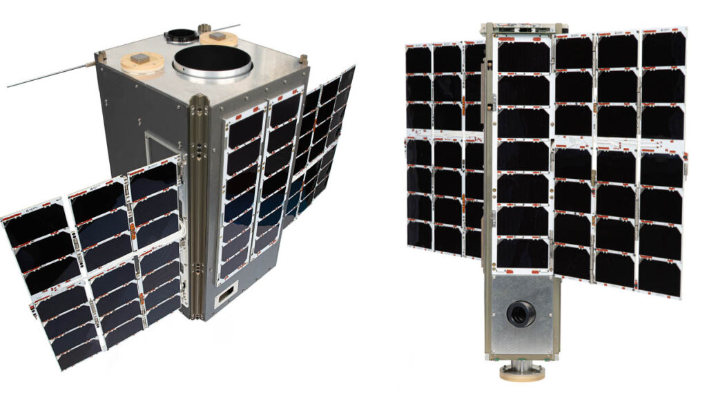
Largest constellation of multifunctional nanosatellites
Fully deployed satellite constellation covering multiple orbital planes and replenished at every rideshare launch opportunity, enabling reliable worldwide coverage of its best-in-class, in-house designed STRATOS GNSS receiver.
Rich, unique datasets harness GNSS signals of opportunity
Spire’s STRATOS receiver has achieved several world firsts by collecting observations from multiple GNSS frequencies (L1, L2, L5, etc) and constellations (GPS, Galileo, GLONASS, BeiDou, QZSS), maximizing radio frequency (RF) diversity and quantity of observations.
Resilient observations and continuous technology improvement
A constellation of nanosatellites is inherently resilient to disruptions and our extensive ground station network enables reliable data downlinking. New and improved Spire nanosatellites are launched in batches multiple times per year.
Driving innovation with space-powered insights
The data we collect from Earth’s surface and atmosphere fuel groundbreaking research, spark new applications, and drive public environmental programs worldwide.
Surface data
We study Earth’s surface using GNSS scatterometry and precise altimetry (GNSS-R) to measure ocean wind speed, soil moisture, flood inundation, and sea ice.
Atmospheric data
Spire monitors our atmosphere with precise GNSS Radio Occultation (GNSS-RO) soundings to improve global weather forecasting accuracy.
Space weather data
We monitor the ionosphere using measurements of electron density and scintillation to augment GNSS accuracy, allowing you to prepare for and react to weather events in space.
Redefining data science with space-based innovation
Weather Forecasting
Revolutionizing weather forecasting
Spire Global is transforming weather forecasting with GNSS Radio Occultation (RO), a groundbreaking technology that enhances forecast accuracy in the short, medium, and long-range. As the leading commercial provider of RO data, Spire’s proprietary STRATOS GNSS payload generates thousands of high-resolution atmospheric profiles daily, offering unmatched global coverage and precision to meet the demands of modern meteorology.
NASA independently validated Spire’s GNSS Radio Occultation (RO) data, confirming its comparability to leading systems and its ability to fill data gaps, deliver fine vertical resolution, and penetrate atmospheric layers crucial for climate research. Spire is now advancing RO technology with polarimetric antennas, enabling precise measurements of precipitation and cloud properties. These innovations further improve Numerical Weather Prediction (NWP) models, enhancing weather and climate forecasting.
Spire is advancing GNSS technology to new frontiers with GNSS Reflectometry, delivering precise monitoring of ocean surface winds, waves, and other critical variables like soil moisture that significantly enhance weather forecasting. Furthermore, Spire is pioneering the use of Hyperspectral Microwave Sounders to gather highly detailed water vapor and temperature data, unlocking unprecedented accuracy in Numerical Weather Prediction (NWP) models.
Climate
Advancing climate insights
Polar regions are among the most vulnerable to climate change, experiencing the highest long-term temperature fluctuations, according to the IPCC. Spire Global has advanced its GNSS Radio Occultation (RO) processing to include surface reflection measurements of these critical areas.
Spire’s sea ice classification products demonstrate strong alignment with other ancillary institutional sensors, offering reliable insights for monitoring polar environments. Additionally, GNSS signal phase data enables the detection of relative sea ice height with remarkable accuracy, within 10 cm. With unmatched spatial and temporal coverage, Spire’s technology enhances existing climate missions, providing a critical tool for understanding polar dynamics and augmenting global climate monitoring efforts.
Soil moisture
Real-time soil moisture monitoring
Soil moisture plays a vital role in understanding climate dynamics, influencing agriculture, drought prediction, and ecosystem health. Spire Global leverages GNSS Reflectometry to deliver high-resolution soil moisture data with unparalleled accuracy and global coverage. By analyzing reflected GNSS signals, Spire’s technology provides real-time data on soil moisture levels, even in remote and challenging regions.
These insights empower industries such as agriculture, water management, and renewable energy to optimize operations, mitigate risks, and adapt to a changing climate. Discover how Spire’s innovative Soil Moisture Insights are driving meaningful climate intelligence.
Space weather
Ensuring resilience with space weather data
Spire’s space weather observations enhance GNSS reliability by monitoring ionospheric disruptions in real-time, as noted by NOAA, and ultimately ensuring safer navigation for autonomous vehicles, electrical grid security, and other critical applications. Researchers have also recognized the accuracy and value of Spire’s Precise Orbit Determination data, which can be used to enhance thermosphere modeling, enabling satellite operators to improve their path prediction and space situational awareness.
Datasets offering
Data sample
Up to one week of data, from one or more satellites
Radio Occultation Profiles
Total Electron Content files
POD files
Magnetometer data
API access
Access data types of your choice from the existing Spire API
Data from the full observing fleet
Flexible pricing based on data type, volume, latency, and usage rights
Custom APIs / interfaces available
Atmospheric data
GNSS-RO profiles for improved weather forecasts and accuracy:
Bending angle profiles
Dry temperature profiles
Refractivity profiles
Space weather & space situational awareness data
GNSS-based ionospheric monitoring:
Total electron content (TEC) data
Electron Density profile
Ionospheric scintillation indices (ISI)
Modeled ionospheric now and forecasts (under development)
Precise orbit determination (POD)
Earth’s surface data sets
GNSS scatterometry and precise altimetry (GNSS-R):
Soil moisture
Sea ice classification & altimetry
Surface water mapping – river, wetlands, flooding (under development)
Ocean winds & waves (under development)
Our data assessments
Our RF-based Earth Intelligence data has been evaluated and successfully validated as part of assessment studies carried out by established global and national scientific agencies, including NOAA, NASA, ECMWF, and UK Met Office.
Spire has a rich legacy of collaboration with institutions to develop on-orbit capabilities and demonstrate the utility of novel GNSS products.

Explore the possibilities
Trial data samples to experience the depth and quality for yourself. We’ll work with you to customize a pricing plan that fits your data types, volume, latency, and usage needs.
Our tailored weather solutions
All the solutions you need for better-informed decisions
DeepInsights™
Experience a comprehensive suite of weather forecasting tools and data visualization capabilities.
DeepVision™
Monitor your entire network of assets, both fixed and moving, in a single viewing application.

Deep Navigation Analytics™
Weather intelligence platform for maritime, leading the transition towards a sustainable future.
Our weather data making an impact in the real world

Hidden corridors: How soil moisture and climate shape coca production and trafficking dynamics in Colombia
Across Colombia’s southern frontier, coca cultivation continues to expand – not only because of enforcement pressures or economic incentives, but because the terrain itself encourages it.
Read more
Beyond the rainfall: How soil moisture tipping points drove China’s 2025 flood disaster
Using satellite soil moisture validation to uncover how saturated soils amplified China’s July 2025 flood disaster.
Read more
From fields to frontlines: How soil moisture shapes military operations in Ukraine and beyond
How battlefield mud, climate intelligence, and GNSS-R satellite data are reshaping military mobility in the Russia-Ukraine war.
Read more
How inaccurate weather forecasts cost the global economy billions – and what Spire is doing about it
Today, the unpredictable nature of our global climate is more apparent than ever, with brutal heat waves testing our power grids, flash floods destroying towns and businesses, and hurricanes evacuating cities and driving people from their homes.
Read more