Spire’s data assimilation breakthrough enhances weather forecast accuracy with GNSS-R
Empowering utilities, logistics, and energy trading sectors with more accurate high-resolution forecasts thanks to Spire’s satellite-derived ocean wind speed observations — and three exceptional women in the field of data assimilation.
World class assimilation of GNSS-R data
The GNSS-R project involved developing a forward operator to assimilate GNSS-R L2 data, which provides ocean wind speed measurements critical for improving forecasts in regions where accurate data was previously scarce. By assimilating GNSS-R Level-1 DDM or Level-2 ocean wind speed retrievals, Spire’s DA team demonstrated that near-surface wind forecasts could be improved significantly.
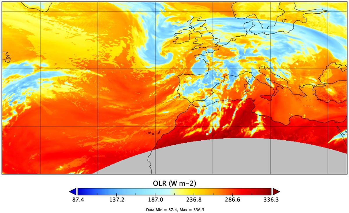
An 8 km Spire High-Resolution Forecast initialized the day before Storm Babet impacted Ireland and the United Kingdom
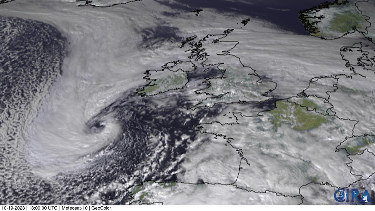
A Meteosat-10 GeoColor satellite image shows Storm Babet at 13 z on October 19, 2023. Credit: (CSU/CIRA & EUMETSAT)
GNSS-R ocean observations enhanced Spire’s High-Resolution Forecast for 2-meter temperature, 10-meter wind speed, and precipitation, boosting high-impact weather predictions.
Validation against METAR station data during Storm Babet in 2023 revealed that both L1 and L2 GNSS-R observations enhanced 10-meter wind speed predictions, with GNSS-R L1 DDM proving most impactful in shorter-term (0-19 hour) forecasts and L2 data excelling in increasing accuracy beyond 37 hours.
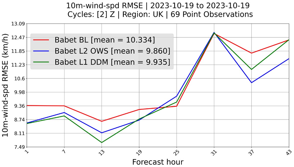
10-m winds root mean square deviation (RMSD) due to the assimilation of GNSS-R ML DDM and L2 ocean wind speed.
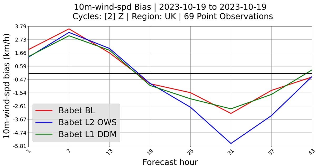
10-m bias reduction due to the assimilation of GNSS-R ML DDM and L2 ocean wind speed.
For energy traders, utilities, and logistics firms, this leap in forecast accuracy presents new opportunities to optimize resources, anticipate demand changes, and improve efficiency across their operations.
Spotlight on the GNSS-R innovators
This project’s success is due in no small part to the dedication of three exceptional women in the field of data assimilation.

Kari Apodaca-Martínez joined Spire after over 10 years of experience at NCAR, Colorado State University, and the University of Miami’s NOAA-cooperative institutes. Her previous experience leading satellite data assimilation projects helped her master the theoretical and computational aspects of advanced data assimilation.
She has expertise in developing algorithms for satellite instruments like GOES-GLM, EUMETSAT-Aeolus, NASA-CYGNSS, and Spire GNSS-R. Kari earned her PhD from Howard University and a Bachelor of Science in Physics and Mathematics from the University of Texas at El Paso.
Her leadership and problem-solving skills have been crucial in tackling GNSS-R data integration challenges. Kari’s extensive background in managing research-to-operations projects funded by NOAA, NASA, and the Navy has played a key role in Spire’s achievements in this R&D project for NASA.
“I’m excited to be part of a team that’s at the forefront of weather forecasting technology,” Apodaca-Martínez said, underscoring her commitment to making GNSS-R data assimilation a success for Spire and its clients.
NOAA has now included the assimilation capability in their 2024 upgrade to their operational DA system, and they’re currently testing it—not with CYGNSS data, since it’s not real-time, but with near real-time Spire data.
“By collaborating with NOAA’s team [and other agencies], we can demonstrate the best way to assimilate this data,” Apodaca-Martínez said. “This could potentially lead them to purchase Spire data, as they wouldn’t need to develop the capability from scratch—we’ve already done that. It’s also a way for us to give back, with the ultimate goal being to improve weather prediction, help businesses thrive, and protect life and property. Those are the most important outcomes.”

Sanita Vetra-Carvalho pursued her passion for data assimilation by earning her PhD in the field at the University of Reading, which has a longstanding partnership with the Met Office UK and ECMWF.
Reflecting on her journey, Vetra-Carvalho noted, “Data assimilation holds the power to deepen our understanding of anything that can be modeled and observed, leading to more accurate predictions and insights.”
“My interest in applied mathematics, that led me to data assimilation, stemmed from my love of both logic and creativity,” she added. “I wanted to find answers through solid, logical methods, but I also wanted the freedom to be creative. Applied math offered that balance.”
Her background in ocean and atmospheric models enabled her to develop algorithms that integrated GNSS-R data effectively into Spire’s High-Resolution Forecast model, contributing to the project’s success.

Kristen Bathmann, with a PhD in applied mathematics from North Carolina State University, brought her experience from NOAA’s National Centers for Environmental Prediction (NCEP) Environmental Modeling Center (EMC), specializing in satellite data assimilation and algorithms for the GFS model.
“Among other things, I worked on bringing new radiance and radio occultation (RO) instrument observations into the GFS model, and worked on improving assimilation algorithms for these observations,” she said.
“I have extensive experience implementing satellite observations to weather prediction models,” Bathmann explained. While this project was her first experience with practical machine learning, her background in mathematics and deep understanding of tackling difficulties that can arise when using new satellite observations prepared her for this R&D project.
Bathmann played a key role in building the machine learning FO that allowed Spire to assimilate GNSS-R data, marking a groundbreaking achievement in the field.
Impact by sector: Leveraging enhanced forecast accuracy with GNSS-R dataEnergy trading
- Improved solar forecasting: GNSS-R data enhances the accuracy of cloud cover and solar irradiance predictions, helping energy traders optimize solar power generation forecasts. Ultimately, this leads to more informed trading decisions and energy purchase and sale strategies.
- Wind energy forecasting: By refining wind speed and direction data, traders gain more reliable insights to adjust wind farm output predictions and trading positions.
- Demand response optimization: With more accurate temperature forecasts, energy companies can manage resources more efficiently, reducing costs and boosting profitability.
Utilities
- Enhanced grid management: Accurate temperature extremes help utilities balance energy loads and prevent outages during peak demand.
- Infrastructure planning and maintenance: GNSS-R can provide insights into precipitation patterns and flood risks, aiding utilities in planning for infrastructure maintenance and upgrades and reducing service disruptions.
- Storm preparedness: Enhanced weather forecast accuracy allows utilities to prepare more effectively for severe weather events, such as hurricanes, by minimizing the potential for outages and improving response times.
Logistics
- Route optimization: Accurate weather forecasts can help logistics companies better plan delivery routes, avoiding severe weather to cut fuel costs and improve customer satisfaction.
- Supply chain resilience: Precise weather forecast data aids companies in adjusting inventory levels and minimizing disruptions in the supply chain.
- Real-time decision making: Enhanced weather data supports real-time operational decisions, increasing efficiency and reducing expenses.
Looking ahead: Advancing machine learning in data assimilation
Spire’s DA team continues to push the limits of what’s possible in data assimilation. The success of GNSS-R data integration paves the way for further innovations, including machine learning-based radiance bias correction and soil moisture assimilation from GNSS-R observations.
By continuously enhancing data assimilation capabilities, Spire Weather & Climate aims to deliver even more accurate forecasts, benefiting industries that rely on precise, real-time data to drive decisions.
“Looking ahead, I’m excited about the potential to keep pushing the boundaries of weather forecasting. There’s so much innovation happening at Spire, from leveraging machine learning to enhance predictions to expanding our satellite data capabilities. I feel fortunate to be part of a team that’s committed to advancing the field and making a difference,” Apodaca-Martínez said.
With this pioneering work in GNSS-R data assimilation, Spire has solidified its position as a leader in weather prediction, delivering unparalleled insights with its high-resolution weather forecast model to clients in industries, including energy trading, utilities, and logistics.
“The unique advantages of Spire’s data include global coverage,” Apodaca-Martínez explained. “The NASA mission is focused on the tropics, but Spire’s proprietary fleet of satellites offers increased coverage, improving weather predictions not just in the US or Europe but also in other regions like Southeast Asia.”
The global scale of Spire’s satellite coverage and data is particularly important for the Southern Hemisphere.
“Wind patterns vary significantly closer to the poles, where there’s far more ocean area and fewer surface observations available, especially in the Southern Hemisphere,” Vetra-Carvalho said. “As we continue to build our fleet of satellites in sun-synchronous orbits, the observations will significantly enhance forecast accuracy. This impact will contribute to saving lives, protecting property, and reducing the economic losses associated with disasters and business interruptions.”
As industries look to weather data to optimize resources, protect assets, and drive profitability, the Spire Weather & Climate team continue to innovate, ensuring that our forecasts are more accurate and actionable than ever.
 Written by