Bridging Earth data gaps: Spire and LatConnect 60 empower agriculture and beyond
- A mission rooted in accessibility and sustainability
- Spire's GNSS-R technology: Building on Soil Moisture Insights for advanced applications
- Closing crop yield gaps and addressing food security
- Revolutionizing emergency preparedness
- Driving innovation in the Asia-Pacific and Australia
- A partnership poised for growth
In a world where data fuels decisions, partnerships between companies like Spire Global and LatConnect 60 are reshaping how industries leverage satellite-derived insights.
LatConnect 60, an Australian leader in Earth observation solutions, recently highlighted its mission to address critical data gaps across Southeast Asia and Australia.
With Spire Weather & Climate‘s proprietary data capabilities, especially its GNSS-R data and Soil Moisture Insights, complementing LatConnect 60’s Earth observation data and innovative platforms, this collaboration aims to unlock unprecedented value for agriculture, resource management, emergency preparedness, and beyond.
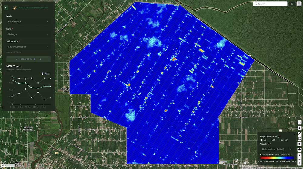
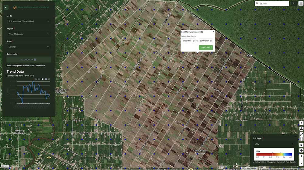
Lot Analytics with Soil Moisture readings: Soil moisture data will help in irrigation planning and drought mitigation by providing the water availability content in the soil.
A mission rooted in accessibility and sustainability
LatConnect 60’s co-founders set out with a vision: to democratize access to high-resolution satellite data and prioritize sustainability-focused sectors. Unlike many observation companies in Australia and Southeast Asia, LatConnect 60 focuses on areas complementary to defense and security, including agriculture, land use, carbon monitoring, and other commercial applications that benefit the planet.
“I come from the space industry in North America, where I’ve worked with notable companies, and during my business development work in Australia and Southeast Asia, particularly, I noticed a general lack of awareness about the value of Earth observation data and how it could be accessed or analyzed. Specifically, the role of high-resolution imaging satellites in sectors beyond defense and security was often overlooked,” said Venkat Pillay, CEO and Founder of LatConnect 60.
“Our drive has been around how to make Earth observation data sets more usable, more accessible, not so restrictive as well in terms of end-user licensing,” Pillay added.
Five years in, LatConnect 60 has downstream clients that understand the value of Earth observation data and its robust applications. One data gap that remained was soil moisture to layer on top of LatConnect 60’s data from satellites using optical imagery and shortwave infrared.
“That’s where we see a tremendous synergy with Spire moving forward,” Pillay said.
Using the latest technology, even more value can be derived for businesses and governments.
“Australia relies heavily on external data sources due to a lack of sovereign observation satellites,” Rueben Rajasingam, LatConnect 60 Co-founder and COO, explained. “Our platforms bridge this gap by integrating satellite data with AI-powered insights to support critical industries like agriculture and resource management.”
Lot Analytics with NDMI Readings: Normalized Difference Moisture Index (NDMI) assesses water content in vegetation to monitor moisture stress and overall crop health across lots.
Spire’s GNSS-R technology: Building on Soil Moisture Insights for advanced applications
One standout collaboration is the integration of Spire’s Global Navigation Satellite System Reflectometry (GNSS-R) technology into LatConnect 60’s platforms. Soil moisture monitoring—critical for arid regions like Western Australia—benefits immensely from the synergy between Spire’s daily soil moisture data and LatConnect 60’s advanced visualization tools.
With these insights, stakeholders can track water use, manage crop health, and optimize biomass forecasting at scales ranging from national to farm-level granularity. Users can access dynamic dashboards, perform day-by-day statistical assessments, and apply tailored data layers to meet their specific needs.
“The current thrust for LatConnect 60 and understanding clients in the areas of agriculture and sustainability, there definitely is an ongoing need for understanding moisture,” Rajasingam said. “Ultimately, what’s critical is moisture in the biomass.”
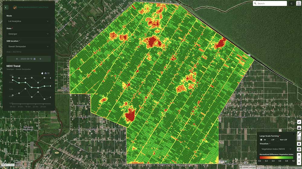
Lot Analytics with NDVI Readings: Normalized Difference Vegetation Index (NDVI) gives insights on crop health by indicating the density of vegetation across lots. Tracking the changes over time helps to identify trends in crop vitality.
“For the prediction aspect of things, if you understand what’s happening with soil, then there’s forward understanding of what’s going to be happening with the biomass itself, whether that’s for forests or whether that’s for your broadacre crops,” Rajasingam continued.
Besides Spire’s Soil Moisture Insights being updated daily, the LatConnect 60 team noted that another game-changing aspect is the fact that the GNSS-R data is not affected by cloud cover or whether it is day or night. That’s particularly important due to cloud cover issues in the rainy, tropical environment of Southeast Asia. Other alternative methods like flying drones and Synthetic Aperture Radar (SAR) imagery are relatively costly.
Additionally, LatConnect 60 is working to utilize multi-spectral satellite data for even more granular soil moisture details.
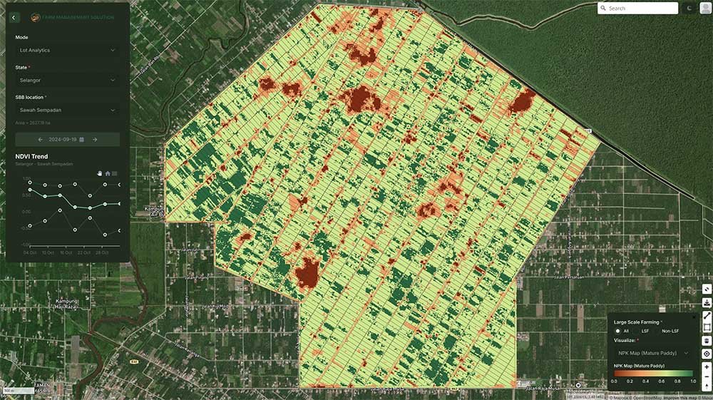
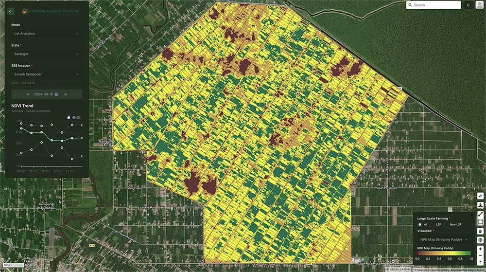
Lot Analytics with NPK Readings during the growth stage: Soil nutrient levels like Nitrogen, Phosphorus, and Potassium (NPK) data are useful to support targeted fertilization and soil management for optimized crop growth.
Closing crop yield gaps and addressing food security
LatConnect 60 uses Spire Soil Moisture Insights as a baseline and factors in other elements like soil type and agronomic methodologies to create yield trending, yield forecasting, and crop stress insights, not only helping with food security but also cost savings in terms of water, fertilizer, and pesticide usage.
“A lot of Southeast Asian countries export rice, but yet they still don’t have enough for their own local consumption. And that yield gap is sometimes over 40%. So that’s pretty significant,” Pillay explained.
“The challenge is how do you get some of the local farmers who may not have the capacity to build up smart farming insights up to the speed and level of some of the more sophisticated farmers who are achieving the yield targets,” Pillay said. “That’s where we come in.”
Satellite-enabled solutions offer a more cost-effective and a less invasive alternate to traditional smart farming systems such as IoT sensors or flying drones, bringing significant value for a broader impact.
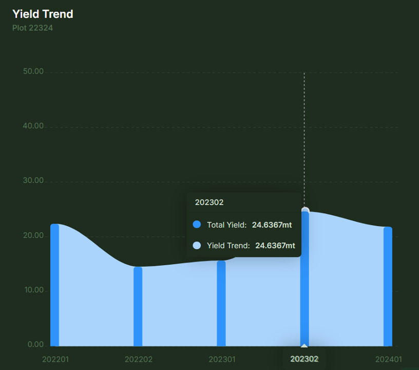
Yield Trending: By combining a time-series of historical yield data with remote sensing readings like NDVI, NDMI, NPK, and soil moisture data, it can generate crop yield trends and yield prediction for improved agricultural outcomes.
Revolutionizing emergency preparedness
The benefits of this collaboration extend beyond agriculture. Soil moisture data also plays a vital role in bushfire monitoring and water management. By combining Spire’s GNSS-R readings with biomass data, LatConnect 60 enables more accurate fire risk predictions—critical for improving emergency preparedness in vulnerable regions like Western Australia.
“Governments are beginning to recognize the importance of proactive data collection,” Rajasingam said. “Our partnerships with state and federal agencies focus on building predictive models that align environmental and emergency response efforts.”
Driving innovation in the Asia-Pacific and Australia
The partnership between Spire and LatConnect 60 aims to address unique challenges in agriculture, resource management, and climate resilience.
Upcoming events, such as a November 26 showcase in Malaysia with representation from the Malaysian Space Agency, the Thai Space Agency, and others, highlight the growing interest in these solutions. By offering demos of their integrated platforms, LatConnect 60 and Spire hope to demonstrate the value of their partnership to an even broader audience.
Yield Trending: By combining a time-series of historical yield data with remote sensing readings like NDVI, NDMI, NPK, and soil moisture data, it can generate crop yield trends and yield prediction for improved agricultural outcomes.
A partnership poised for growth
LatConnect 60’s modular platforms, now standardizing Soil Moisture Insights across deployments, underscore the flexibility and scalability of its approach. The LatConnect60 team customizes platforms for client needs with agility and speed.
“We take the heavy lift away from the client. We do the data processing of the GNSS-R with Spire and layer that into our platform along with complementary datasets,” Pillay explained. “And the client at the end of the day just gets a better, more precise service.”
By integrating Spire’s data and leveraging AI-powered analytics, these solutions provide actionable insights for industries ranging from agriculture to emergency management.
“Our partnership with Spire has strengthened our ability to deliver comprehensive, user-friendly solutions that meet the needs of diverse markets, particularly agriculture and governments,” said Pillay. “We’re excited about the potential to expand these unique capabilities and drive even greater impact across the Asia-Pacific region and Australia.”
Spire and LatConnect 60 are bridging gaps in data access, delivering critical insights, and empowering industries and governments to thrive in an ever-changing world, including addressing some of the most pressing issues of our time such as food security and climate change.
Learn more about Spire and LatConnect 60
 Written by