Turning space data into actionable insights
Spire is a data and intelligence company that collects and processes data from space to solve problems on Earth. We design, build, and operate our own satellite constellation, ground stations, and software infrastructure to deliver unique insights from the ultimate vantage point — space.
Through our data, analytics, and software products, we enable government and commercial customers to make better decisions in a rapidly changing world. From strengthening global security to reducing the impact and cost of weather and climate risk, we turn space-based data into actionable intelligence.
Government solutions
A trusted partner for your most critical missions
Reliable and resilient data and space services for enhanced situational awareness and smarter decision-making in a changing world.
Spire’s government solutions provide mission-critical satellite data for security and defense initiatives worldwide. Spire’s radio frequency geolocation solutions help agencies enhance security and counter dark actors. Our APIs and customized datasets deliver precise aviation, weather, and environmental insights for improved situational awareness. Strengthen global security operations with Spire’s market-leading Earth, atmospheric, and aviation intelligence.
Industry solutions
How can Spire’s industry solutions work for you?
Our industry solutions provide actionable, space-powered data to anticipate challenges, solve problems, and drive measurable results for your business.
Leverage proprietary satellite constellations, advanced atmospheric profiling, and global flight intelligence to power smarter, data-driven operations. From hyper-accurate weather forecasting and climate risk insights to real-time aircraft tracking and aviation analytics, Spire provides timely, reliable, and actionable data. Organizations can use these insights to improve safety, optimize performance, enhance operational efficiency, and build resilience in an ever-changing global environment.
Industry solutions
How can Spire work for you?
Our industry solutions provide space-powered data that anticipate and solve your toughest challenges. Let us show you how our industry solutions can help enrich your business.
Weather & Climate
Unleash the power of cutting-edge satellite technology to enrich data on hundreds of environmental factors. We enable the creation of custom predictive models for accurate Earth monitoring and decision-making support. Our DeepVision™ dashboard combines detailed, near real-time weather and environmental data from across the globe, utilizing both ground and satellite sources for unparalleled insight.
Explore Weather & Climate solutions
Aviation
Spire’s global ADS-B coverage unveils a world of real-time, accurate insights for your industry. Discover next-generation space-based flight tracking data and aviation intelligence. Spire’s EURIALO project will mitigate GPS jamming and create more efficient and safe flight patterns worldwide. Our space-based aviation intelligence solutions give you precise insights to make critical operational decisions. Supercharge your aviation intelligence applications, revolutionize decision-making, and optimize your cost efficiencies.
Explore Aviation solutions
Featured data solution products
Aviation
EURIALO: A new era in air traffic aviation surveillance
The next generation of aviation tracking from space is in development. We will increase global security, minimize the aviation industry’s carbon footprint, and increase efficiency and location accuracy.
Explore EURIALO
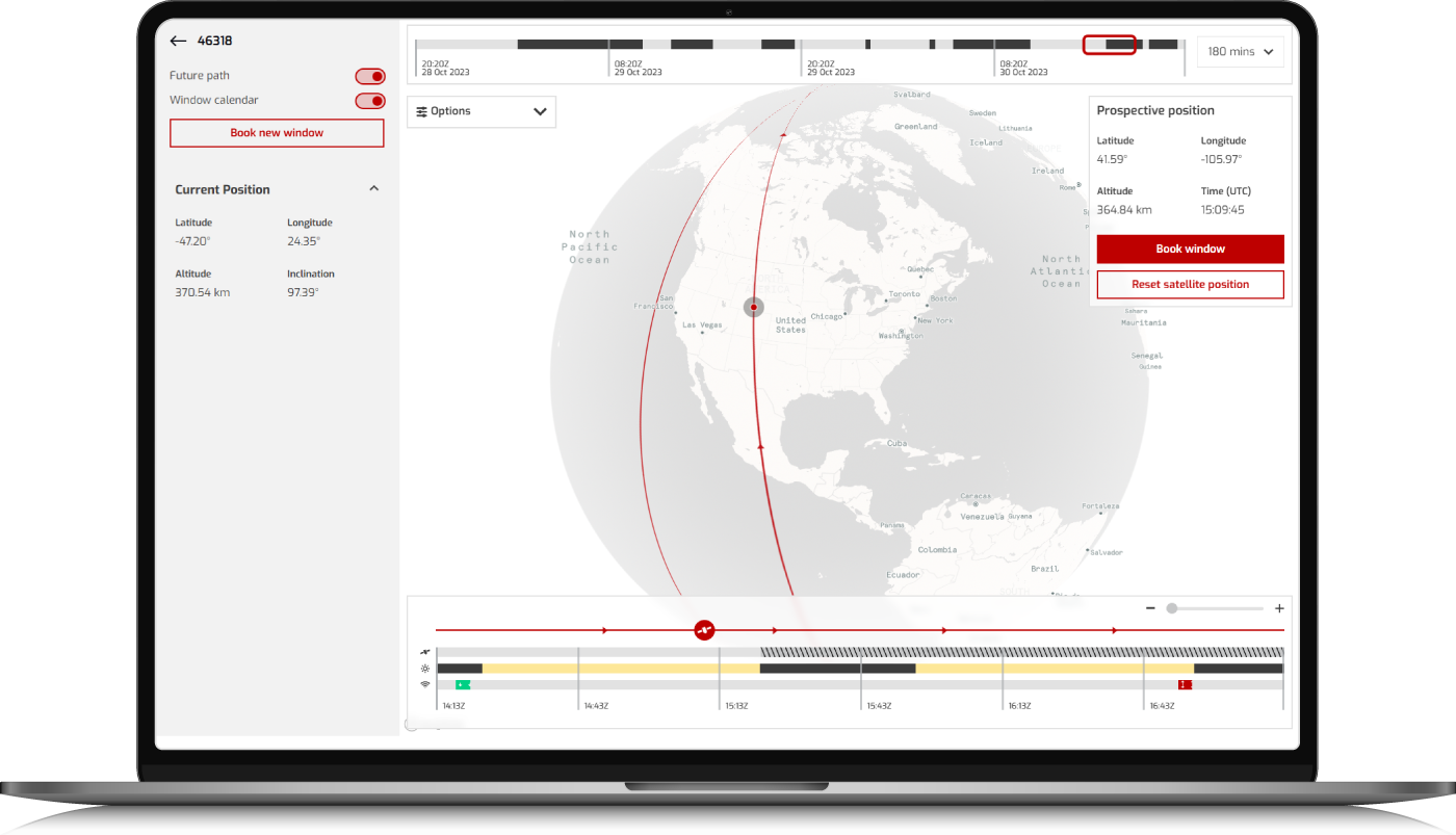
Space Services
Spire’s Constellation Management Platform
Spire’s Constellation Management Platform (CMP) is a tool for streamlining satellite control for our customers; automating operations, simplifying tasks and enabling direct communication with space assets.
Explore Constellation Management Platform
Weather & Climate
DeepVision™: An advanced weather visualization dashboard
Customize your DeepVision™ weather dashboard to swiftly adapt your logistics and transport network to minimize weather-related disruptions in supply chain management.
Explore DeepVision™
Elevate your business, and the world, from the ultimate vantage point – space
We produce custom datasets for your industry using unrivaled radio occultation technology. Every minute we gather rich insights from every point on Earth – including the most remote regions of the planet. We analyze and combined each datapoint with supplemental insights that enable data-driven decisions across the enterprise through easy-to-use APIs. Enhance your industry solution through efficiency, and fuel innovation faster than your competition.
If you could see the entire picture, predict imminent issues, and take action confidently — what would you change?
About Spire
Global insights
Unlock our data & solutions. Spire collects rich and unique datasets that track oceans, skies, land and weather 24/7. Our data collection technique means we can see the ocean currents, winds, and soil moisture.
Elevated data
Building a space-powered, global data network. Spire was formed by founders from three countries scattered across the globe, united by a common desire to build a better planet.
Predictive analytics
Know more, change the future. We know top-quality data – analyzed and enriched by savvy experts – will help build a better future. This is why we work with companies like NVIDIA on the future of weather modelling and prediction.
Spire’s data helps customers predict environmental change and take proactive measures
Our data solutions enhance industry awareness across soil moisture, ADS-B aviation surveillance, and weather models.

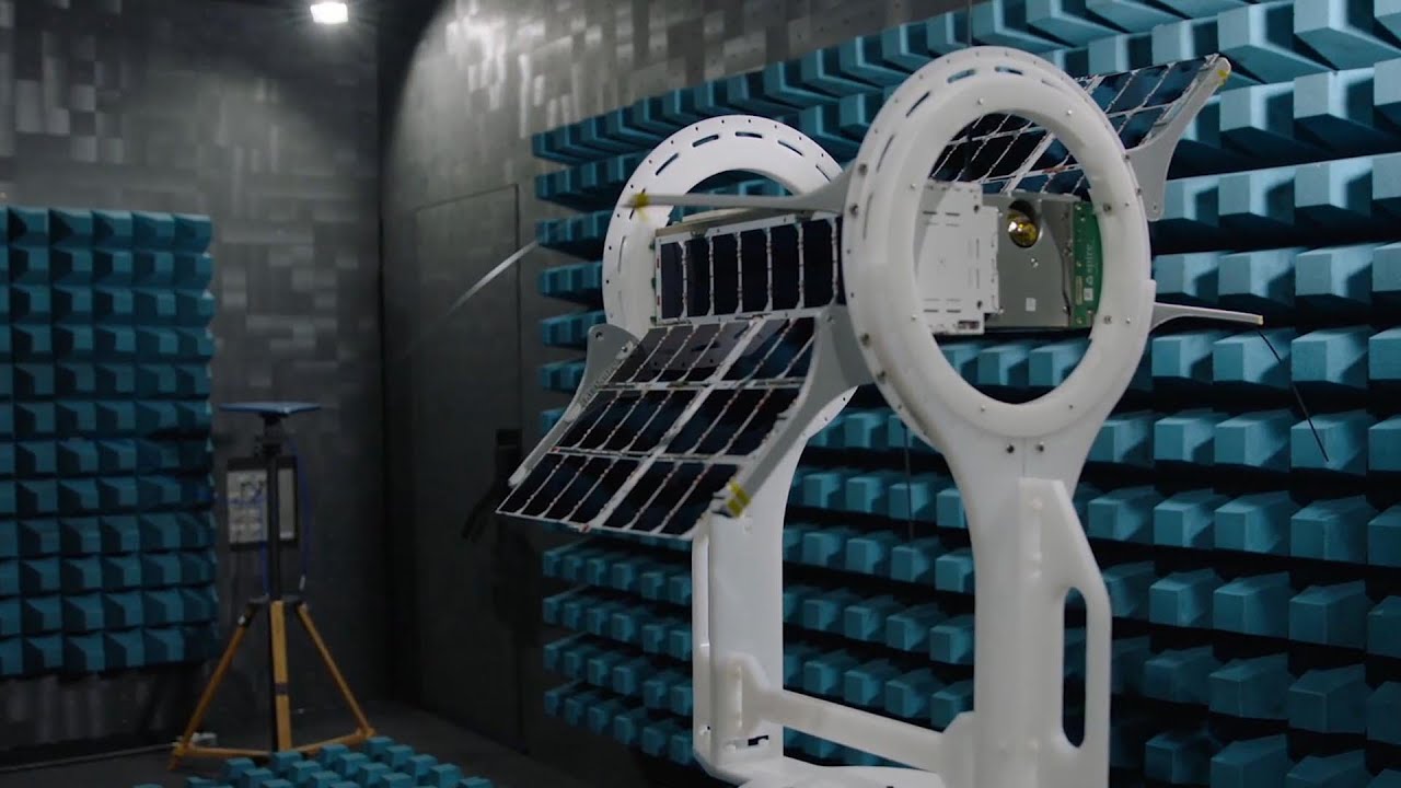
The promise of space is here

Spire Global’s next generation 16U satellite

Mitigating the Supply Chain Bottleneck with Gravity Supply Chain Solutions and Spire Global
Spire’s Technology Difference – Spire’s Satellites Are Software Defined


Join Spire
Space technology careers at Spire Global
We challenge boundaries and develop new frontiers. Want to leave your mark?