A new era in air traffic surveillance: Inside the EURIALO’s satellite constellation and data innovation for resilient and safer aviation infrastructure
 Written by
David McGuire
Technical Project Manager - Spire Global
The upcoming EURIALO space system aims to enhance global air traffic safety and efficiency through cutting-edge space technology innovations.
It will provide continuous independent monitoring of global flight movements, utilizing a network of small satellites orbiting in low-Earth orbit (LEO) complemented by a ground segment dedicated to data processing and dissemination. This would be the first-of-its-kind and most advanced system for aircraft tracking in the world.
The European Space Agency (ESA) has entrusted Spire Global through the branch of Spire Germany GMBH to do the full system design for a global independent space-based aircraft surveillance system. As part of this program, Spire will also develop and operate an in-orbit demonstrator mission.
“We are proud to partner with Spire Global with its strong heritage to develop a best-in-class satellite system design to demonstrate a system that will revolutionise air traffic management and surveillance for safer skies.”
Share on Facebook Share on Twitter Share on LinkedIn
Unveiling the EURIALO project: What is it?
The EURIALO project will design and demonstrate a novel and independent space system that uses a satellite constellation to track aircraft by determining their exact position based on different times of arrivals of radio frequency (RF) signals. In other words, it will geolocate a radio signal from space, a technology known as multilateration (MLAT).
Today, aircraft are independently tracked by terrestrial systems such as radar, a technology used from 1930s onwards. This method has a range of limitations; for example, the need of line of sight, obstacles like mountains, tall structures that limit signal reception meaning that remote or oceanic areas cannot be covered at all. Furthermore, many of these systems need to interrogate aircraft transponders and this often creates a problem of over interrogation which may result in excessive interference and the aircraft inability to reply in extreme cases.
EURIALO’s key objective is to close the gaps and interference exposure left by conventional terrestrial-based tracking systems and dependent space systems, by introducing an independent passive satellite-based surveillance solution of global flight movements.
The importance of establishing an independent aviation surveillance system
Existing space-based air traffic surveillance systems gather ADS-B data, which rely on Global Navigation Satellite System (GNSS) to deliver data. However, GNSS services are vulnerable to interference and spoofing, posing a significant risk and challenge to reliable and resilient air traffic surveillance.
The vulnerabilities of GNSS can result in inaccuracies when tracking aircraft positions, ultimately affecting the efficiency of air traffic control operations and risking safe operations. This is why the development and implementation of a global flight tracking system that is independent from GNSS systems is a critical step toward enhancing air traffic safety and security.
Such a system would provide a resilient solution for tracking aircraft, reducing the dependency from GNSS and ensuring the continuous monitoring of air traffic. This redundancy in surveillance technology not only safeguards the efficiency of air travel but also strengthens aviation’s resilience against potential threats and disruptions.
“Repeated instances of GNSS interference have disrupted air traffic in recent times. This has caused delays, increased cost, negatively affected the environment and ultimately compromised air traffic safety. The industry is in the need of a reliable and resilient surveillance solution.”
Share on Facebook Share on Twitter Share on LinkedIn
Unveiling the new constellation’s operation – GNSS-independent capability
A constellation of EURIALO satellites will establish 100% global coverage, capturing the automatic and frequent radio signals emitted by aircraft during data transmissions. Orbiting in LEO, these satellites will deploy their antenna arrays to consistently receive and track these signals.
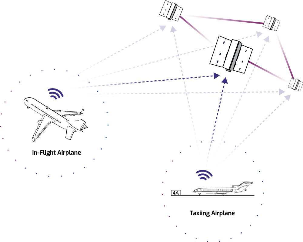
Using the RF signals, these satellites will provide data to ground-based systems that can accurately determine the position of the aircraft. As several satellites receive the same aircraft signal, the intersection point is calculated from the different signal transit times between the aircraft and the various satellites. The position of the aircraft can thus be reliably and accurately determined, independent of GNSS. This information is then relayed to the ground infrastructure to assist air traffic control in monitoring and managing air traffic.
To achieve real-time data transmission, the satellites need to establish direct communication among themselves or via intermediary relay stations. These intersatellite links (ISL) enable uninterrupted communication between all constellation satellites and ground stations. By complementing terrestrial radar surveillance, the system strives to notably enhance the safety of air traffic.
EURIALO in action: Implementation approach
Under the three-year contract, Spire will develop the mission and system design for a full global operational satellite constellation, and then design, deploy and operate a demonstrator mission planned to be launched in 2025 that validates the performance of the designed system and critical technologies.
“EURIALO presents a promising avenue to harness space technology’s potential for aviation advancement. This initiative will involve a constellation of small satellites, enabling real-time, pinpoint determination of aircraft locations.”
Share on Facebook Share on Twitter Share on LinkedIn
Spire is leading a consortium of major industry players, including ESSP-SAS as a sub-contractor through both phases. Following the initial design and demonstrator phases, there is the opportunity to be selected to build out the full constellation, consisting of a large number of satellites.
The EURIALO project extends beyond providing dependable and resilient surveillance of air traffic, it will complement the envisioned European air traffic communication, navigation, and surveillance framework. It will also harmonize seamlessly with global air traffic management to achieve the capability of independent real-time global aircraft tracking from departure to arrival, completing the necessity for a resilient space-based infrastructure to strengthen secure, eco-friendly, and efficient air travel at a global scale.