Harnessing ADS-B data for smarter drone risk assessment strategies
 Written by
Tjasa Pele
Digital Marketing Specialist
Drones are reshaping industries from logistics to surveillance, necessitating stringent safety measures as they navigate low-altitude airspace densely populated with manned aircraft.
The accuracy of risk assessment in these busy skies hinges on having a comprehensive view of all aerial activity. In this blog post, we explore the pivotal role of Spire’s aircraft positions data in ensuring the most reliable operational dashboards and risk assessment.
Specializing in enabling Beyond Visual Line of Sight (BVLOS) of drone operations, an industry worth 3.4 billion USD only in Europe, our customer Skyy Network addresses the crucial challenge of assessing the risks that drone activities pose to manned aircraft in ensuring air safety. One of the major obstacles to gaining operational clearances for drones is evaluating air traffic risks associated with operations as traditional qualitative methods tend to be excessively conservative. To counter this, Skyy Network developed a quantitative software solution that leverages historical ADS-B data on manned air traffic.
As not all manned air traffic carries an ADS-B out device, incorporating other sources of air traffic data was necessary. The all-in-one traffic data from Spire Aviation, which incorporates other technologies such as FLARM, was therefore a key highlight.
The effectiveness of their solution critically depends on the quality of the data used. Only high-quality global coverage data can yield useful and reliable results, ensuring that as much airborne traffic as possible can be considered for modelling.
Elevate your drone operations: simplifying air risk analysis with Skyy Network
Skyy’s risk assessment API streamlines the process for their end user’s customers-drone operators-to quantitatively analyse the air risk associated with their flights. With just one click, drone operators can view which areas and at what altitudes their drone operations carry a minimal risk of encountering manned air traffic. This intuitive tool not only enhances safety but also facilitates faster regulatory approvals for drone activities, making it an essential asset for operators looking to optimize their operations.
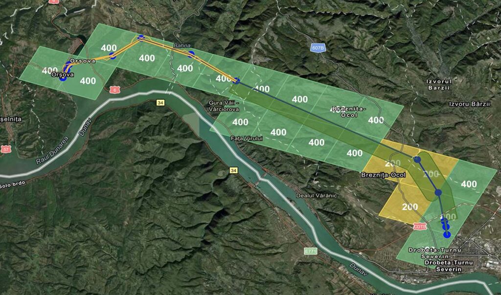
Visualization of risk outputs: each cell contains the maximum safe altitude in feet above ground, where drones can be operated safely
How Dronedesk integrates Skyy Network’s air risk API for smarter drone operations
One of Skyy Network’s end customers, Dronedesk, provides a comprehensive web-based platform for managing drone operations, making it easier and more efficient for operators to plan safe flights. This planning process requires consideration of numerous factors, including risks to people on the ground and other users of manned airspace.
“BVLOS drone operators need an easy, data-driven way to assess air risk, which requires two things: a sophisticated risk model, and high-quality manned traffic data.”
Share on Facebook Share on Twitter Share on LinkedIn
Skyy Network’s air risk API effectively addresses these concerns and seamlessly integrates with Dronedesk’s planning tool. This integration enables users of all sizes, from solo operators to large organizations, to effortlessly incorporate air risk assessments into their regular operation workflows.
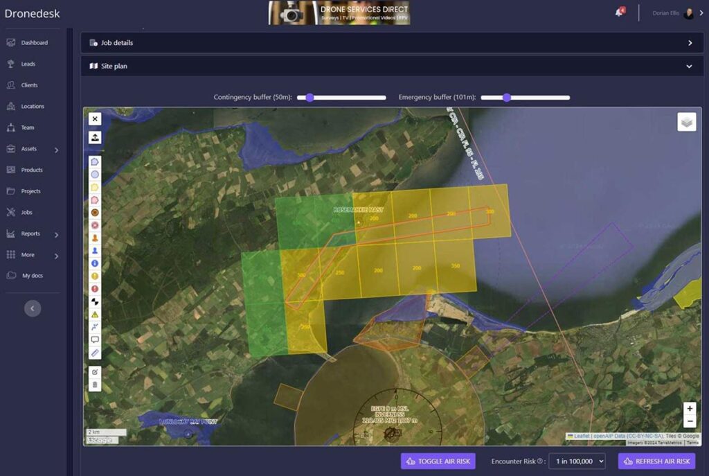
Dronedesk dashboard
For more advanced use cases, drone operators using Dronedesk can leverage Skyy’s advanced risk assessment technology to explore how air risk profiles change with different variables taken into account. Factors such as the time of day, day of the week, and varying operational altitudes can significantly influence risk assessment results. This capability enables operators to safely manage even the most challenging drone operations by adjusting their strategies based on detailed risk insights.
With the space-based global coverage offered by Spire Aviation data and its integration into these tools significantly cut down the hours of administrative work for drone teams by automating the collection of air, ground, and weather intelligence data. It ensures that all risk factors are covered, allowing teams to concentrate on the core aspect of drone operation—flying safely and efficiently while adhering to the standards set by Civil Aviation Authorities. This partnership highlights Spire Aviation’s primary objective of improving the safety and operational efficiency of airspace management.