Mapping tornado hotspots: The world’s most active regions and why
 Written by
Tornadoes are one of nature’s most destructive weather phenomena.
Even though tornadoes can occur almost anywhere in the world, certain regions experience a higher frequency of these violent storms, earning them the designation of “tornado hotspots.” In this blog post, we’ll delve into some of the primary tornado hotspots worldwide, exploring the factors behind their formation and frequency in these regions.
The development of tornadoes hinges on several critical factors, including atmospheric instability, wind shear, and the presence of a triggering mechanism like a cold front. Warm, moist air near the ground must collide with cooler, drier air aloft, creating a highly unstable environment. When this unstable air rises rapidly, it can lead to the formation of a rotating updraft known as a mesocyclone within a severe thunderstorm. If the rotation tightens and intensifies, it can produce a tornado.
While there are regions of the world more prone to tornadoes, violent tornadoes can touch down almost anywhere on the planet, provided the right atmospheric conditions are in place, shedding light on the need for preparedness and weather risk mitigation strategies for businesses and communities.
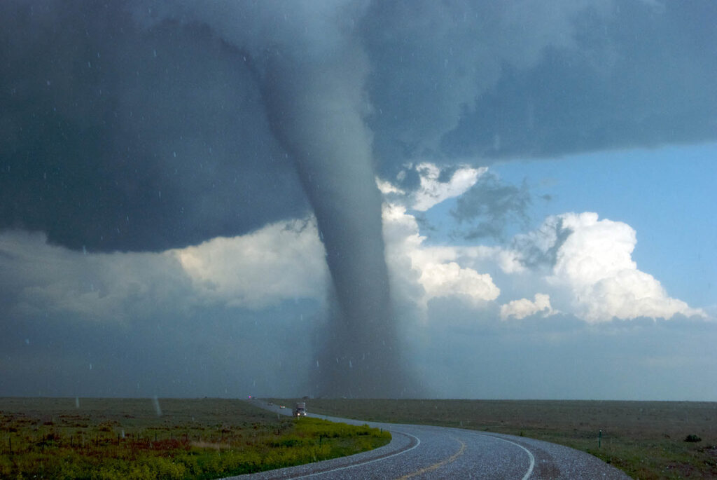
Tornado Alley: The epicenter of tornado activity
Regarding tornado hotspots, few areas are as infamous as Tornado Alley in the United States. Stretching from the southern Plains to the Midwest, Tornado Alley encompasses parts of Texas, Oklahoma, Kansas, Nebraska, South Dakota, Minnesota, Iowa, and arguably parts of Illinois. Tornado Alley typically experiences more than 500 tornadoes on average annually due to the convergence of warm, moist air from the Gulf of Mexico with cool, dry air from the Rocky Mountains. The clash of these air masses creates the ideal conditions for supercell thunderstorms, which often spawn tornadoes.
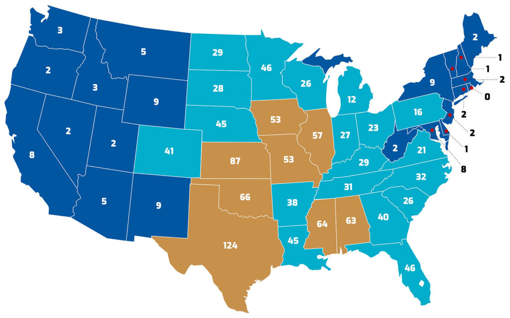
The average annual number of tornadoes per state (CONUS, 2003-2022) based on data from the National Weather Service Storm Prediction Center
The Southern US tornado corridor
In addition to Tornado Alley, the Southeastern United States is another hotspot for tornado activity with this area experiencing nearly 300 tornadoes per year based on the 20-year average from the National Weather Service Storm Prediction Center (SPC). States like Alabama, Arkansas, Mississippi, Tennessee, and Georgia regularly experience tornado outbreaks, particularly during the spring months. Unlike Tornado Alley, where tornadoes are often produced by supercell thunderstorms, tornadoes in the Southeast are more commonly associated with squall lines and mesoscale convective systems (MCSs). Annually, the United States experiences about 1,248 tornadoes on average based on SPC data from 2003-2022.
The catastrophic April 2011 Super Tornado Outbreak, during which over 360 tornadoes struck the Southeast, serves as a stark reminder of how devastating these natural events can be when numerous tornadoes occur in quick succession.
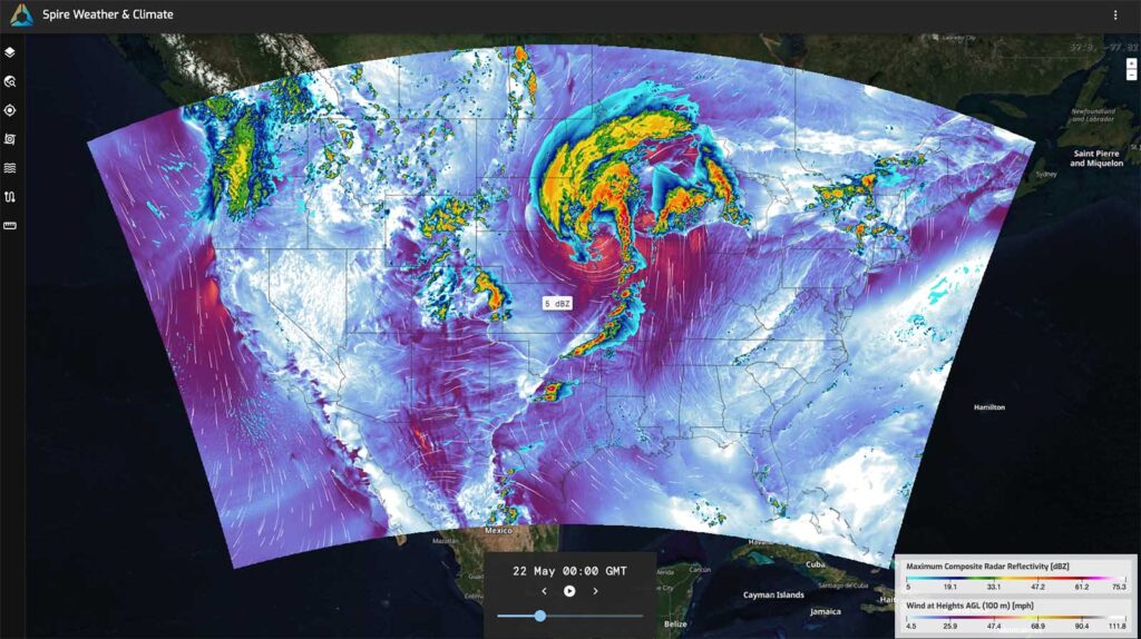
A snapshot of the Spire High-Resolution Forecast depicts severe weather in the heartland of the United States, showing both maximum composite radar reflectivity (dBZ) and winds at 100 m (mph)
Another tornado capital of the world: Bangladesh
While tornadoes in the United States tend to garner the most attention, Bangladesh holds the dubious distinction of being the deadliest tornado capital of the world. Bangladesh experiences a relatively high number of tornadoes compared to its size and population density. On average, approximately 5 to 10 tornadoes touch down in Bangladesh each year.
Notably, the number of fatalities due to tornadoes is relatively high in comparison to the US, according to a report from the University of Colorado. These tornadoes primarily occur during the pre-monsoon season, typically from March to May, when atmospheric conditions are conducive to tornado formation.
The unique geographical and meteorological features of the Bengal Delta contribute to the relatively high frequency of tornadoes in Bangladesh, making it one of the most tornado-prone countries in the world. This atmospheric setup creates favorable conditions for tornado development, with devastating consequences for the densely populated and vulnerable region.
The deadliest tornado ever recorded worldwide struck Bangladesh on April 26, 1989. According to the World Meteorological Organization (WMO), the tornado hit the Manikganj District in central Bangladesh, killing an estimated 1,300 people and injuring another 12,000, leaving 80,000 individuals homeless, and causing catastrophic damage.
Other tornado hotspots around the globe
Beyond the United States and Bangladesh, tornadoes occur in various other regions globally. Canada’s Prairie provinces, Argentina’s Pampas region, and parts of Australia, including the southeastern states of Queensland and New South Wales, and New Zealand are all known for their tornado activity. Each of these regions has a unique combination of geographical features and atmospheric conditions that contribute to favorable atmospheric conditions for tornadoes.
In Europe, some of the highest tornado frequencies are found in countries like Germany, Italy, and England. Germany, for instance, sees a noteworthy number of tornadoes, with many occurring in the northern and central parts of the country. Italy also experiences tornadoes, particularly in the northern and coastal regions, with some causing significant damage.
Greece is among the Mediterranean countries that have experienced significant tornado events. Additionally, hundreds of waterspouts occur each year in the Mediterranean region, and when these move ashore, they can cause damage.
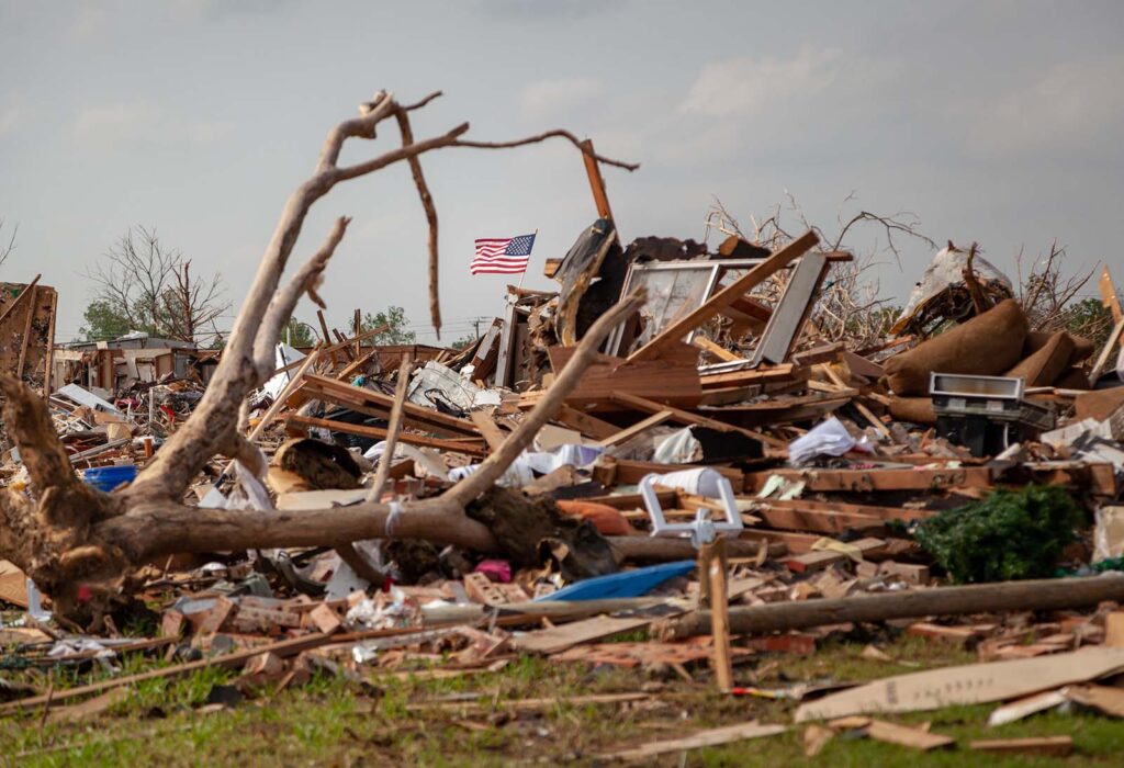
Destruction left behind after an EF5 tornado struck Moore, Oklahoma, in May 2013
Understanding and mitigating tornado risk
While tornadoes are a natural part of the Earth’s atmospheric system, their impact on human lives, livelihoods, and infrastructure can be devastating. Understanding tornado hotspots and the factors that lead to tornado formation is crucial for effective risk mitigation and disaster preparedness efforts. Through investing in early warning systems, community education, and resilient infrastructure, we can minimize the loss of life and property damage caused by these powerful storms.
Precise and reliable weather forecasting information is critical for severe weather preparedness and business resilience amid increasing severe weather concerns.
Our Spire High-Resolution Forecast offers 3 kilometer resolution forecasts for the entire continental United States (CONUS) with hourly outputs extending up to six days. Powered by Spire’s advanced data assimilation system and proprietary Radio Occultation (RO) and reflectivity data, including soil moisture and ocean wind measurements, our High-Resolution Forecast delivers unprecedented accuracy and detail, addressing the critical need for medium-range convective-scale forecasts.
Discover the difference of unmatched detail
 Spire High-Resolution Forecast at 3 km resolution
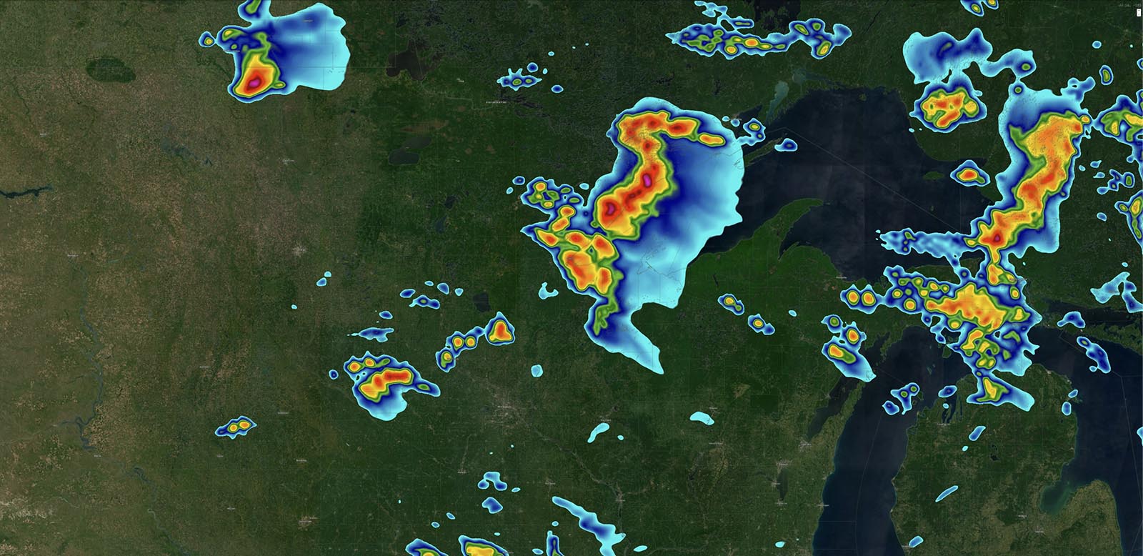
The Spire High-Resolution Forecast (right) depicts highly detailed convective-scale forecasts at 3 km, indicating thunderstorms over the Great Lakes of the United States. The difference in precision is clear when comparing it to a global model snapshot (left).
This significant enhancement sets a new industry standard, providing detailed forecasts essential for predicting extreme weather events such as severe thunderstorms and localized flash flooding. Available via API or Spire’s display system, DeepInsights provides High-Resolution Forecasts that empower meteorologists, energy traders, utility managers, and more with the insights needed to make informed decisions, optimize resource management, and enhance safety protocols.
Additionally, Spire has a team of meteorologists available 24/7 for consultation by phone, chat, video, or email and can provide expert analysis and weather support for your business.


