Spire’s High-Resolution Forecast gave customers an edge on Hurricane Beryl
Meghan Mussoline
Product Marketing Manager, Spire Weather and Climate
Customers using the Spire High-Resolution Forecast had three days of advanced notice to prepare for Hurricane Beryl’s Texas landfall location and impacts.
Recap of Hurricane Beryl’s US impacts
Hurricane Beryl shattered several records over the Atlantic and on land. Beryl formed east of the Caribbean Sea, developing farther east than any June hurricane on record. It went on to rapidly intensify into the earliest-ever Category 5 storm in the Atlantic basin, beating the previous record by 15 days. Beryl caused significant impacts across the Caribbean before crashing ashore near Matagorda, Texas, at 4:00 am CT on Monday, July 8 as a Category 1 hurricane, packing maximum sustained winds of 80 mph.
Beryl’s storm surge pounded the Texas coastline as the hurricane unleashed powerful winds and flooding rainfall, causing widespread damage to infrastructure. Nearly 3 million customers lost electricity, with the Houston area enduring the brunt of power outages. The lengthy outages complicated recovery efforts for businesses and communities. The lack of air-conditioning caused dangerous conditions as sweltering temperatures brought heat indices above 100ºF, putting vulnerable populations at risk.
Hurricane Beryl by the numbers:
165 mph
maximum sustained wind speeds at peak (Cat 5)
80 mph
maximum sustained wind speeds at landfall (Cat 1)
113
record number: US tornado warnings for a day in July
85 miles
distance from Houston, Texas, at landfall
203
2nd-most tornado warnings for a US tropical system
35.1
accumulated cyclone energy, a measure of storm intensity & duration (season: 36.1)
2,300+
flight cancellations caused by Beryl
42 hours
record time from TD to major hurricane this early
~3M
power outages at peak
The storm forced thousands of flight cancellations and temporarily caused disruptions to oil production.
Beryl was also a prolific tornado producer, ranking second behind Hurricane Ivan from 2004 in terms of the number of tornado warnings triggered in the United States from a tropical system.
The economic impact is estimated to be in the billions of dollars, although specific figures are still being assessed.

Floodwaters inundated Buffalo Bayou Park in Houston, Texas, as Hurricane Beryl hit.
Advanced notice from the Spire High-Resolution Forecast allowed our customers to make informed business decisions with confidence ahead of Hurricane Beryl’s landfall. Early and precise forecasts are critical for energy, utility, insurance, and trading interests among other industries as hurricanes approach.
The Spire High-Resolution Forecast is the only 3 km resolution model, with hourly forecast outputs extending to six days over the entire continental United States. This model accurately predicted Beryl’s Texas landfall location before most other models.
Read on to learn more about Spire’s High-Resolution Forecast performance on Hurricane Beryl.
Spire’s early insight into Hurricane Beryl’s northward track toward Texas
The Spire High-Resolution Forecast came within 25 miles (40 km) of Hurricane Beryl’s actual landfall location 78 hours in advance. The 06Z Spire High-Resolution Forecast from Friday, July 5 was the first to indicate a northward trend, or right turn, in Hurricane Beryl’s track toward the Texas coastline twelve hours before other models.
The advanced notice and consistency in model runs provided confidence in the forecast for Spire customers, allowing more time for better decision-making.
“For those following the models, Beryl was a difficult forecast as most models had a consistent southern bias. I did my own analysis and found this new Spire High-Res model among the best and earliest indicators of the Houston impact. It also did a great job indicating which portions of Texas would not be impacted. Both are important to know.”
Share on Facebook Share on Twitter Share on LinkedIn
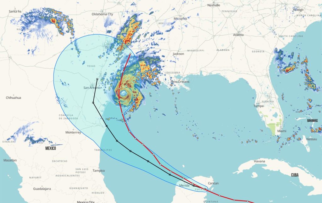
Spire High-Resolution Forecast for Maximum Composite Radar Reflectivity 78 hours before Beryl’s Texas landfall. The National Hurricane Center’s forecast cone at 78 hours is pictured in light blue shading, Beryl’s observed track is shown in red, and the NHC’s forecast track 78 hours out is shown in black.
Our three-day Spire High-Resolution Forecast showed Beryl making landfall between Corpus Christi and Galveston, Texas, at 7:00 am CT on Monday, July 8. ECMWF’s forecast for the same cycle and valid time had a track much farther to the south in Texas. However, in subsequent runs, it began picking up on the northward track trend.
Successive runs of the Spire High-Resolution Forecast homed in further on the landfall location, coming within 10-20 miles with a lead time of 30 hours. Additionally, the model precisely captured impacts from the hurricane’s most powerful winds along the coast and inland at least two days ahead.
“The Spire High-Resolution Forecast pinpointed the risk of winds of 60 mph and greater through the Houston, Texas, metroplex 48 hours out, providing higher confidence to impacts and timing when and where it mattered the most,” Spire Meteorologist and Weather Risk Expert Jared Allen explained. He added that the model accurately depicted the front right eyewall core passing over Houston with wind gusts up to 80 mph at least 40 hours in advance.
Maximum wind speeds occurred near where Hurricane Beryl made landfall along the northern Texas coast and inland to Houston, Texas, according to the National Weather Service. A wind gust of 97 mph was recorded in Brazos, Texas, and widespread 70 and 80-mph wind gusts occurred along the coast and inland, including in downtown Houston, on the right front quadrant of Beryl’s eyewall core.
Why should you consider a high-resolution forecast?
Energy and commodity traders, utilities, and insurance providers are among the industries that should consider improved hurricane forecasts from a precise and high-resolution forecast.
Discover Spire’s comprehensive weather intelligence and solutions for businesses.
Explore Spire Weather & Climate
Why did Spire forecasts perform better?
Our fully deployed satellite constellation helps to fill critical weather data gaps, especially in under-observed remote areas and over the oceans. The proprietary data that Spire gathers allows for better initial weather conditions, which are a major driver of forecast accuracy.
Spire’s Radio Occultation (RO) data provided an improved sampling of atmospheric conditions, especially over the ocean, enhancing the accuracy of forecasts for steering influences on Hurricane Beryl.
RO is a groundbreaking technique that allows for the retrieval of vertical atmospheric profiles similar to those generated by measurements gathered from a weather balloon. However, whereas weather balloon launches are costly, manual, and mainly over land, RO is scalable, automated, and can be performed anywhere globally.
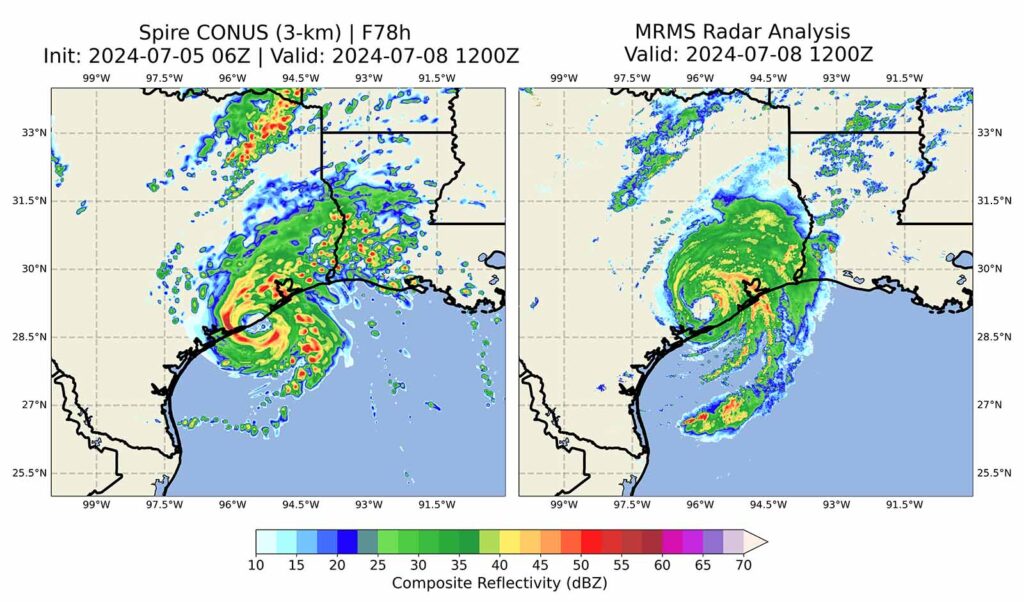
The Spire High-Resolution Forecast provided early insights into Hurricane Beryl’s track toward the Texas coastline twelve hours before other models. The image on the left shows the Spire High-Resolution Forecast position for Beryl at 12Z July 8th, initialized at 06Z on July 5th. The image on the right shows Hurricane Beryl’s actual position at 12Z July 8th.
Spire’s constellation of satellites can accomplish this feat by analyzing the bending of signals from GPS/GNSS satellites due to weather elements. Because of that, Spire offers unparalleled coverage, filling in weather data gaps and providing invaluable data from the poles to the remote oceans.
Hurricane Beryl’s rapidly fluctuating strength and structure and weak steering influences created a complex forecasting scenario. Besides improved weather data for initial conditions, which has been proven to be among the top means for increasing weather forecast accuracy, our high-resolution forecasting capabilities added value for our customers.
High-resolution, convection-allowing forecasts are critical for capturing the fine-scale convective processes and ocean surface interactions that influence the intensity and track of tropical systems.
“Spire assimilates vast quantities of high-quality observations, including Spire’s proprietary satellite data, using its internally developed data assimilation system. This end-to-end ownership of the data pipeline allows us to extract maximum value from observations and ultimately enhances forecast accuracy, as exemplified by our forecasts of Hurricane Beryl.”
Share on Facebook Share on Twitter Share on LinkedIn