What role did soil moisture play in Hurricane Helene’s devastating floods?
- How soggy soil worsened flooding during Hurricane Helene
- Heavy rain event before Helene left the southern Appalachians more vulnerable to flooding
- Soil Moisture Insights analysis for Hurricane Helene
- Historic flooding event involving a tropically fueled atmospheric river
- Lessons learned from Hurricane Helene and past flood events
Meghan Mussoline
Product Marketing Manager, Spire Weather and Climate
As Hurricane Helene barreled toward the Gulf Coast, an often-overlooked factor had already primed the southern Appalachians for disaster: saturated soil.
How soggy soil worsened flooding during Hurricane Helene
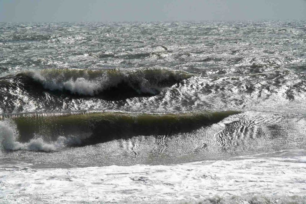
When it comes to flood risk, soil moisture plays a crucial role. While drought and vegetation damage may be the first things that come to mind, the opposite—elevated soil moisture—can dramatically worsen flooding. This was evident during Hurricane Helene’s catastrophic flooding across the southern Appalachians, where already saturated soil significantly amplified the magnitude of flooding, mudslides, and damage.
In the days leading up to Category 4 Hurricane Helene’s landfall along the Gulf Coast of Florida, heavy rain poured down over western North Carolina and surrounding areas of South Carolina, eastern Tennessee, and northern Georgia. The relentless rain caused soil moisture levels to spike, peaking by September 27th. When Helene arrived, the already-soaked ground could no longer absorb any more rain, drastically increasing the flood risk. Fully saturated soil prevents rainfall from being absorbed, leading to runoff that causes rivers and streams to overflow.
The deluge from Hurricane Helene was historic, with the 20-30 inches of rainfall across the southern Appalachian region hitting levels seen less than 0.1% of the time (an annual recurrence interval greater than 1,000 years), according to the National Weather Service Office of Water Prediction. But the damage wasn’t entirely due to rainfall directly associated with Helene.
Regional Soil Moisture Insights
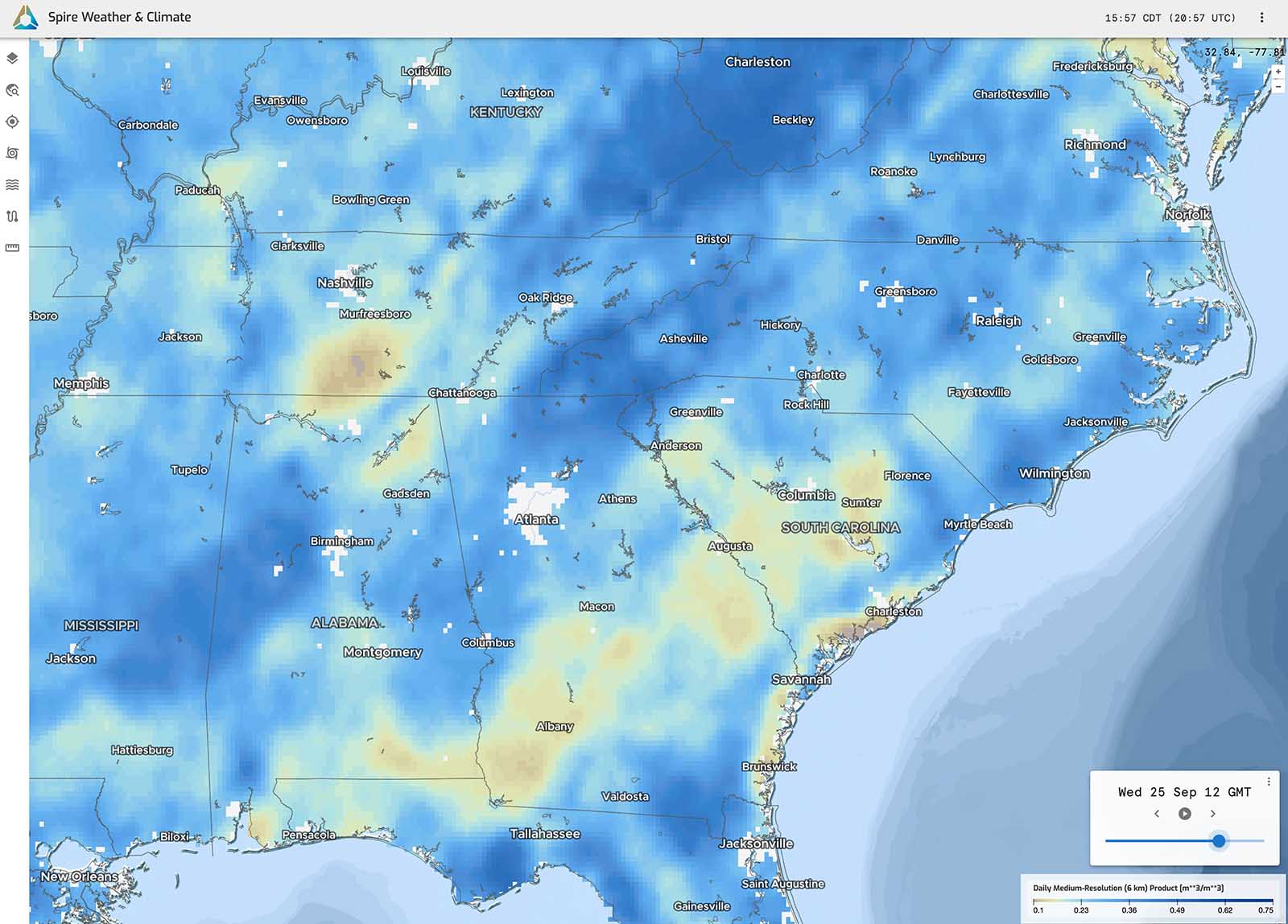
The left map, valid September 19, 2024, ahead of Hurricane Helene indicated mixed soil moisture conditions in the Southeast US with dry soil shaded yellow and areas with greater surface soil moisture shaded in light blues. The right map, valid September 25, 2024, shows an increase in soil moisture ahead of rainfall directly associated with Hurricane Helene.
Heavy rain event before Helene left the southern Appalachians more vulnerable to flooding
An atmospheric river, fueled by moisture from Helene funneled ahead of a cold front, driving unprecedented water vapor into the region ahead of the storm’s arrival. Integrated vapor transport (IVT), a measure of atmospheric river strength, reached 3,000 kg/m/s in western North Carolina, more than 1.5 times the previous record, according to meteorologist Ben Noll. In other words, the atmospheric river delivered a torrent of tropical moisture into the southern Appalachians.
Atmospheric rivers—narrow corridors of concentrated moisture—often bring excessive rainfall, especially when air is forced upward by mountains, as was the case in the Carolinas. These “rivers” of water vapor are some of the largest freshwater conveyors on Earth, surpassing the flow of the Amazon River. When combined with saturated soil, as in the case of Helene, the flood potential is greatly intensified.
Rainfall amounts of 8-12 inches were recorded in the southern Appalachians before rainfall directly associated with Helene arrived.
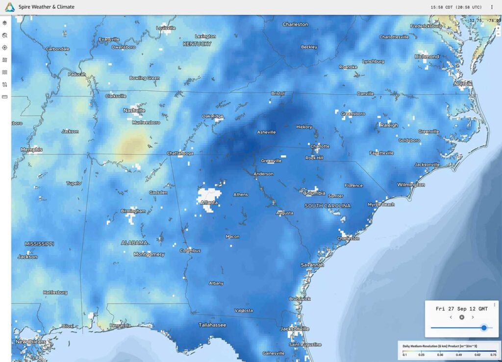
A regional Soil Moisture Insights map valid September 27, 2024, indicating wet soil due to Helene’s heavy rainfall across much of the Southeast US. The darkest blue shading from northern Georgia to western portions of the Carolines and eastern Tennessee correlate with the corridor of heaviest rainfall from the tropical system.
Soil Moisture Insights analysis for Hurricane Helene
Spire’s Soil Moisture Insights reveal a crucial piece of the puzzle in understanding how Hurricane Helene’s historic flooding unfolded in western North Carolina and surrounding states.
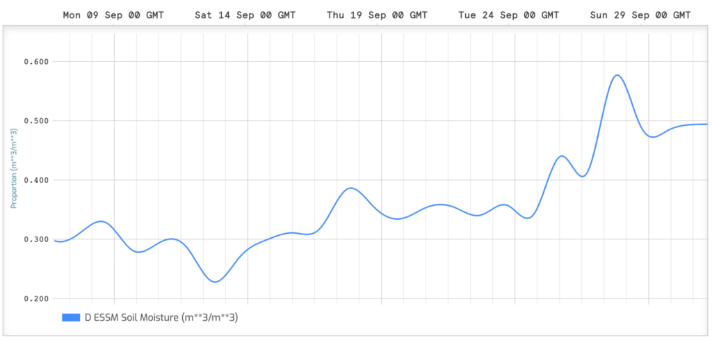
A chart of 500 m soil moisture data over time for a location just northeast of Asheville, North Carolina, including before, during, and after Helene’s flooding. Note the change from the baseline of around 0.3 up to ~0.4 m3 /m3 prior to the hurricane, and then spiking at around 0.6 m3 /m3, while falling down to a much higher temporary baseline as the communities began picking up the pieces.
“In the days leading up to the catastrophic flooding caused by Hurricane Helene in North Carolina, soil moisture levels rose significantly, especially around Asheville. These increases, first observed on September 25th and peaking by the 27th, meant that the soil was already completely saturated when the hurricane struck. When soil is saturated, it can’t absorb additional rainfall, greatly increasing the risk and severity of flooding,” Dennis Quick, Spire Remote Sensing Data Analyst and Sales Engineer, said.
As Quick further explained, saturated soils left little room for excess rainfall, causing floodwaters to rise more rapidly in rivers and streams. While the water levels in waterways peaked and receded relatively quickly, on land, the effects were more prolonged, with floodwaters lingering due to the slower drainage across the saturated terrain.
If the soil takes a while to dry out, the region will be more susceptible to future power outages and wind damage such as falling trees due to abnormally moist soil.
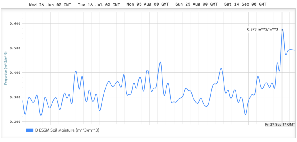
A chart of 500 m soil moisture data for the same location just northeast of Asheville, North Carolina, but zoomed out further on the timeline to show data for roughly four months (June – September 2024). This highlights the more typical spikes in surface soil moisture from routine precipitation events, in contrast with the much larger spike of Helene’s precipitation.
“That’s something to watch out for the remainder of the hurricane season and into the fall months when synoptic scale systems tend to have stronger winds,” Spire Director of Product Management and Meteorologist Chris Manzeck said.
Historic flooding event involving a tropically fueled atmospheric river
A similar event occurred in early October 2015, when South Carolina and parts of North Carolina endured historic flooding. Hurricane Joaquin became an intense Category 4 storm — just shy of Category 5 force – well off the US East Coast. While Hurricane Joaquin never made landfall in the United States, it contributed to the event by sending tropical moisture toward the Carolinas. The tropical moisture interacted with a non-tropical storm system that developed over the Southeast US, dumping rain for days on end.
Over the course of five days, more than 20 inches of rain fell in some areas, with Mount Pleasant, South Carolina, recording nearly 27 inches. The extreme rainfall overwhelmed infrastructure, breaching 18 dams, and causing widespread destruction. This flooding, like Helene’s, was worsened by already saturated conditions and tropical moisture surges, proving that even a hurricane that doesn’t make landfall can cause catastrophic impacts.
Lessons learned from Hurricane Helene and past flood events
The devastating impacts of Hurricane Helene and similar past events underscore the importance of monitoring soil moisture ahead of extreme weather events like landfilling hurricanes. By tracking these factors, meteorologists, governments, and emergency managers can better anticipate flood risks and help communities and businesses prepare for the most severe outcomes.
Spire’s Soil Moisture Insights solution is now available in Cirrus, Spire Weather & Climate’s data visualization platform, with 6 km and 500 m soil moisture data that can be visualized in charts for any location around the world. Additionally, soil moisture maps are viewable for regional trend analysis.