Spire’s high-resolution soil moisture data now delivered in under 24 hours
 Written by
Spire Global
High-resolution, daily global soil moisture data offers unparalleled insights, enhanced by AI, and now with significantly reduced latency, benefiting agriculture, insurance, climate intelligence, and environmental risk sectors.
What’s new with Spire’s Soil Moisture Insights product?
Spire’s enhanced near real-time soil moisture product sets a new industry benchmark, delivering gap-filled, global soil moisture data with an unprecedented latency of under 24 hours. Thanks to advancements in both satellite data collection and processing infrastructure, users around the world can now access daily soil moisture data at 12:00 p.m. local time, representing conditions from the previous day at the same hour.
Figure 1 illustrates how this data becomes progressively available across different time zones, enabling more timely and consistent environmental insights at a global scale.
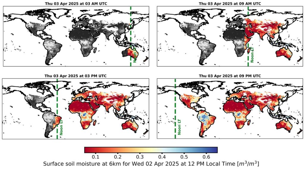
Global time-lapse of Spire’s 6 km medium-resolution, near-real-time soil moisture data from April 3. The product, delivered with less than 24-hour latency, reflects soil moisture conditions as of April 2 at 12 p.m. local time. The background shows the full near-real-time product as of April 1 in grey.
Available at 6 km, 500 m, and 100 m resolutions, the product integrates seamlessly via our API, delivering fast, reliable, high-resolution soil moisture intelligence for diverse applications.
Why does near real-time soil moisture data matter?
Reducing data latency has been one of the most common requests from our clients. By delivering near-real-time soil moisture data, Spire is unlocking a broad range of time-sensitive, high-impact applications, including:
- Early warning systems for drought, flood and wildfire risks
- Soil moisture forecasting for agriculture and hydrology
- Risk assessment for insurance and financial sectors
With this latency cut—from 96 hours to under 24 hours—Spire makes satellite-based soil moisture data significantly more valuable for real-time decision-making and operational use cases.
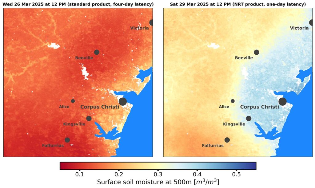
Temporal comparison of Spire’s 500 m soil moisture product over South Texas. Previously, a March 30 request would return data from March 26 (left). With the new sub-24-hour latency data stream, users access more recent observations (right), revealing higher soil moisture levels that contrast with the drier conditions shown in the four-day latency product.
How did Spire achieve sub-24-hour soil moisture data delivery?
Achieving sub-24-hour global soil moisture delivery required a significant engineering effort, driven by two key innovations:
- Expanded access to low-latency satellite data. We broadened our data ingestion pipeline to incorporate additional low-latency observations from Spire’s GNSS-R LEMUR satellite constellation—including the recent launch of two new GNSS-R satellites—as well as external datasets such as NASA’s soil moisture measurements.
- Optimized processing infrastructure. We enhanced our cloud-based processing system to efficiently manage large volumes of satellite data, enabling faster computation and seamless delivery at scale.
These combined improvements allow Spire to deliver high-resolution, gap-filled soil moisture data with global coverage in near real-time—empowering users with faster, more useful insights.
What makes Spire’s near real-time soil moisture intelligence unique?
Spire’s soil moisture product stands out thanks to a combination of technical precision, consistency, reliability, and usability. The key differentiators include:
- High spatial resolution, available down to 100 meters
- Daily global observations, delivered at 12:00 pm local time
- Low latency, with data available in less than 24 hours
- Spatio-temporal gap-filled coverage, ensuring consistency
- Global scale, with seamless integration
The gap-filling capability is particularly valuable for Earth observation and AI applications. By providing harmonized, ready-to-use datasets, Spire eliminates the need for extensive calibration and validation steps. This allows users to integrate soil moisture data directly into models and decision-making workflows, without dealing with missing values or preprocessing challenges.
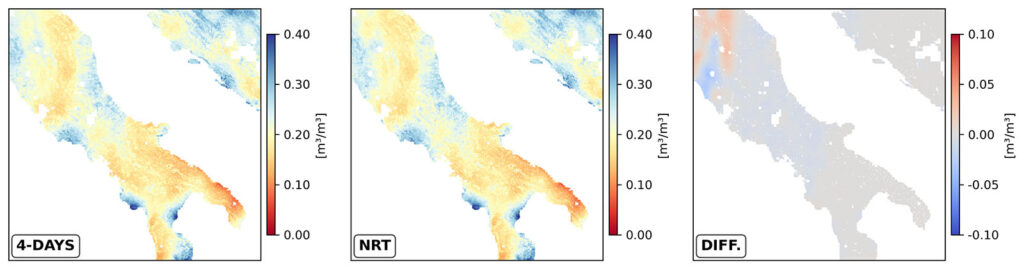
Direct comparison of Spire’s 500 m soil moisture product over southern Italy: four-day latency (left) vs. new one-day latency (middle). Both reflect the same date, with minor differences (right) due to variations in sensor data inputs—demonstrating the high quality of Spire’s new near-real-time product.
What’s next for Spire’s Soil Moisture Insights?
2025 is shaping up to be a transformative year for Spire’s Soil Moisture Insights products. Our development roadmap is focused on delivering even more value to both existing and future clients.
As our satellite constellation grows, the system is designed to scale naturally, further reducing latency and improving data resolution. We’re also continuing to refine our processing pipeline to boost accuracy, speed, and geographic coverage.
Most importantly, we’re committed to listening to client feedback—integrating new features and enhancements based on user needs. Whether you’re building AI models, managing agricultural risk, or monitoring climate conditions, Spire’s soil moisture data will keep evolving to power your most critical decisions.