Why aviation needs space-based surveillance now, not later
 Written by
Vividha Chopra
Product Marketing Manager
The aviation industry relies heavily on GNSS signals (mainly GPS) to operate aircraft safely and efficiently.
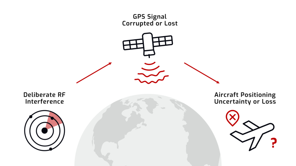
Today’s airspace, however, is increasingly complex, crowded, and difficult to manage. To make matters worse, GNSS jamming and spoofing are becoming more common, with certain global regions seeing constant interruptions, often due to ongoing geopolitical tensions.
Without the right tools to identify and mitigate issues stemming from these GNSS signal interferences, everything is at risk – from operational efficiency to passenger safety.
As flights continue to increase globally and GNSS interference becomes more threatening by the day, it’s clear that the world needs modernized solutions for more resilient airspaces. Rather than taking a reactive approach when issues occur, we need systems to alert us when a plane enters a high-risk airspace, enabling us to pivot and take action to mitigate the potentially fatal fallout.
Below, we outline why we need modernized aviation management solutions, what’s at risk if we don’t evolve, and how space-based solutions can help drive everything from profit to efficiency and safety.
GNSS interruptions and the threat to aviation
GNSS interruptions are a rapidly growing threat to the aviation industry, and GNSS jamming and spoofing occur all day, every day, all around the world.
The rising threat of GNSS interference
While the aviation industry is dependent on GNSS systems, those signals are extremely vulnerable to disruption. Those who stand to benefit from this have now ‘weaponized’ GNSS interference, and it’s causing very real problems in the global airspace.
In fact, the growth statistics from recent years are clear.
- In 2021, just under 11,000 GNSS interference incidents were recorded.
- In 2022, that figure jumped to more than 49,000 incidents.
- Between August of 2023 and March of 2024, around 46,000 interruptions were reported over the Baltic region alone.
- In 2024, the relatively small country of Finland reported 2800 disruptions in just its airspace.
We are seeing a trend: a rapid increase in the number of GNSS interruptions, and they don’t show any signs of slowing.
While GNSS jamming and spoofing are increasing globally, occurrences are particularly high in high-traffic zones (HTZs), war zones, and regions with ongoing geopolitical conflicts. This is undoubtedly why we are seeing such a spike in the Baltics, although things are trending upward regardless of the war.
While most countries have laws and regulations around GPS jammers, the devices are relatively easy to obtain, even where they are not legally purchased. Even military jammers are being found in the hands of civilians, so the laws and regulations are not slowing the impact.
Aviation security and passenger risk
Apart from efficiency and typical air transit concerns, GNSS interference puts everyday people at risk. For commercial airlines, a loss of GNSS signal results in the plane vanishing from radar. When GNSS signals go missing, so do the planes – at least digitally. In this case, pilots can be forced to divert routes or enact emergency procedures without the security of GNSS navigation – no location on radar and no data about other aircraft in the shared airspace.
It’s also challenging for air traffic control (ATC), forcing them to manage things with a high level of uncertainty, often attempting to manage multiple aircraft at once.
Simply put, situational awareness in the airspace is critical to keeping people safe, traveling on schedule, and assets intact. Even brief GNSS disruptions can create a snowball effect that can affect anything and everything in tandem.
To fully grasp the risks GNSS interference presents to aviation, it’s essential to understand how a simple signal disruption can quickly escalate into a significant loss of aircraft visibility, which we cover below.
Understanding the GNSS interference journey
When GNSS interruptions happen, the impact on aviation isn’t always immediate. Instead, it tends to unfold through a ‘domino effect,’ so understanding each step of the process can help you see how small events can lead to significant problems.
Step 1: The jamming event
Jamming happens when GNSS signals are jammed via signal jammers. This can, and often is, an intentional effort, but jamming can also be unintentional, as GNSS signals are relatively weak and any stronger RF signal on the same frequency can overpower the original.
While jamming sources are often simply handheld GNSS jamming devices, they may also include jamming from military exercises, electronic warfare, or accidental emissions from non-compliant RF devices.
Regardless of the source, once a rogue signal overtakes the original by overpowering the frequency band, legitimate signals are drowned out and no longer recognized.
Step 2: Signal integrity degrades
When GNSS receivers have trouble understanding the difference between legitimate and illegitimate RF signals, all signal integrity diminishes. When this happens, it often results in things like position drift (aircraft ‘seemingly’ wander from their true location), tracking systems lose their ‘lock’ onto known satellite references, and ADS-B degradation (the geolocation position broadcast from aircraft).
By the final stage, aircraft might still be operating normally and without fail, but the systems (and operators tracking them) will start to encounter anomalies that make airspaces hard to manage.
Step 3: Aircraft positional data fails
If or when jamming lasts for an extended period or intensifies over a short window, the situation can become increasingly dangerous.
Not only can an aircraft disappear entirely from radar, but air traffic control teams can no longer reliably track the flight, resulting in the inability to route other flights that could potentially interfere with those not on radar. Pilots might also need to revert to backup navigation, which can increase their workload, operational complexity, and more. Ultimately, this mix puts people and assets at risk.
While most of these outcomes are manageable in open airspaces, condensed or contested airspace is different. Even minor disruptions can evolve into serious risks, so mitigating things that lead to miscommunication, delayed responses, or midair safety issues should be of top interest.
The escalating threat
The threats stemming from GNSS interference are no longer hypothetical, and they are creating a full restructuring of operations within aviation.
Today’s GNSS jamming hotspots
While GNSS jamming is on the rise across the globe, there are specific regions that are currently seeing massive spikes. These occurrences are causing disruptions, delays, and security concerns that have caused havoc for many.
Today, the following are considered the world’s GNSS jamming hotspots.
Eastern Mediterranean
The Eastern Mediterranean is one of today’s jamming hotspots due to the ongoing political tensions in the region, which include tensions in Israel, Egypt, Syria, and Libya. Since GNSS jamming and spoofing have been primary strategies for nations to protect their interests, the region is a ‘high-risk’ zone for jamming and spoofing.
Eastern Europe
In Eastern Europe, the situation is similar to that of the Mediterranean. The ongoing conflict between Russia and Ukraine is creating a high concentration of electronic warfare, driven by GNSS jamming and spoofing. Nearly every one of Russia’s borders is showing jammed GNSS signals, as seen in the image below. It is important to note that this is likely a mix of civilian and military jamming sources, with the likelihood that the majority are military.
East Asia
In East Asia, the contested South China Sea accounts for most of the jamming, but it also includes the border between North and South Korea, as well as the Yellow Sea. GNSS disruptions in this part of the world have been consistent and continue to disrupt flights and communications in the area.
Future growth and aviation demand
While it’s obvious that GNSS disruptions are a problem for aviation, that fact is compounded by three clear trends.
- Growing Air Traffic: According to forecasts, air traffic is expected to grow to 12 billion passengers, an approximately 33% increase compared to today. By 2042, that number is projected to reach 19.5 billion.
- Urban Air Mobility (UAM) Expansion: New forms of aircraft and air travel are arriving every day, including drones, autonomous aerial vehicles, and even air taxis.
- Increased Geopolitical Instability: While geopolitical tensions are always a concern, GNSS jamming and spoofing are now a core strategy within them, so we will continue to see increases in interference globally, even if the number or severity of conflicts remains relatively consistent.
Addressing the pressing challenges involved with today’s aviation landscape is going to take more than typical strategies using ground-based surveillance. At Spire, we are looking multiple steps ahead, creating innovative, space-based technologies to develop solutions now, not later.
How Spire is responding
The present and growing threats of GNSS interference demand more than awareness. They require cutting-edge, innovative technologies and scalable solutions that help provide resilience to the future aviation landscape.
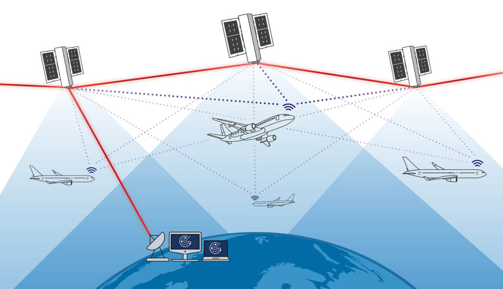
At Spire, we are uniquely positioned to meet the challenge, enabling near real-time interference detection from LEO. Our approach comprises two primary strategies, as outlined below.
1. Spire’s reconnaissance solutions: Interference detection as a data service
Spire operates one of the world’s most advanced space-based RF sensing constellations, actively scanning Earth’s surface for signs of GNSS jamming and spoofing. These spaceborne sensors capture RF anomalies in near real-time, and include things like signal loss, multipath distortion, and power-level inconsistencies that flag spoofing or jamming attempts.
Using proprietary detection algorithms, Spire is able to geolocate and timestamp interference events, track jamming patterns over time, and identify GNSS spoofing based on signal structure and behavioral anomalies.
Organizations are able to tap into specialized datasets that give direct measurements of interference events, can assess the health and quality of satellite signals in specific regions, and alert users of deviations based on GNSS performance patterns.
All interference datasets are available in standard aviation and geospatial formats (GeoJSON, CSV, KML, etc.) and can integrate with existing surveillance systems, decision dashboards, or early-warning tools via API or flat-file delivery.
This is all particularly beneficial to airlines, air traffic controllers, aviation authorities, and military defense organizations, giving insight into the modern airspace where ground systems fail to deliver.
2. Spire’s space-based aviation surveillance: The EURIALO program
In addition to providing real-time data to our customers, we are actively building next-generation surveillance capabilities through our partnership with the European Space Agency (ESA), European Satellite Services Provider (ESSP) and The German Space Agency ( DLR).
Overview of EURIALO
Spire was recently awarded a $16 million contract to design and demonstrate a LEO-based surveillance system as part of ESA’s EURIALO program. This system will outperform traditional ground-based infrastructure used for aviation and create a more resilient surveillance solution.
How does it work?
Direct signal collection: Spire satellites collect aircraft positional data (ADS-B signals) directly from transmitters aboard the plane. Spire’s satellites don’t rely on fixed infrastructure or vulnerable line-of-sight coverage like traditional ground stations. Instead, they capture ADS-B signals from LEO, giving sight across oceans, deserts, and remote territories – areas where ground surveillance stations are typically blind.
On-orbit processing: Signals are processed in LEO with Spire’s advanced software-defined radio (SDR) payloads, executing real-time demodulation, timestamping, and signal characterization directly onboard the satellite. This unique approach reduces data latency, enables rapid decision-making, and eliminates the need to downlink raw RF data before analysis – a critical differentiator in time-sensitive airspace management.
Ground delivery: Aircraft position updates are transmitted to ground stations in near real-time, delivering immediate visibility of aircraft movements. Spire’s global network of low-latency ground stations ensures rapid data dissemination to aviation customers and enables seamless operations, be it for national or commercial applications.
Dual capability: Surveillance + interference detection
EURIALO satellites will help solve two major challenges with a single unified system: aircraft tracking with near real-time updates for aircraft position and trajectory, and GNSS interference detection to help aircraft avoid interruptions in the airspace.
The dual capability drives security for decision-makers, knowing that they can both take a proactive approach to potential problems and manage the situation if unavoidable.
The future of aviation safety requires space-based solutions
The aviation industry can no longer rely on ground-based surveillance systems. They need future-ready management tools that are only accessible from space.
Before we dig into the specifics, let’s briefly revisit two important questions.
- Why are ground-based systems no longer enough? Line-of-sight restrictions, terrain interference, regional blackouts, and physical vulnerabilities.
- Why is space-based surveillance a non-negotiable? A need for persistent global coverage, resilience to localized disruptions, and faster detection/response times.
The reality is that while ground stations still matter, they are not sufficient to safeguard the airspace. Space-based monitoring and detection are needed to build resilience against aviation projections.
Multilateration (MLAT) for GNSS-resilient positioning
While detecting GNSS interference is critical, it’s only half of the solution. When GNSS degrades or is denied, operators need to know when it occurs, immediately, and figure out exactly where aircraft are post-outage. This is where MLAT comes into play.
What is MLAT?
MLAT allows users to determine the location of an aircraft by comparing the time it takes for the ADS-B transmission to reach numerous receivers. Rather than relying on GNSS satellite timing, it functions independently, creating something that is inherently resistant to jamming and spoofing.
Why MLAT matters for aviation security
Independent Verification: MLAT offers a way to independently verify an aircraft’s location without relying solely on GNSS data.
Interference Resilience: Even in regions affected by jamming, MLAT provides reliable aircraft positioning.
Enhanced Safety: Layered surveillance methods (GNSS + MLAT) improve redundancy, instilling trust in aviation tracking systems.
Space-based MLAT, powered by Spire
At Spire, we are already building the foundation for space-based MLAT, which is able to be applied without launching a new class of satellites. It’s the orbital architecture and real-time data capabilities that make it possible.
- Distributed Satellite Coverage: Spire satellites simultaneously receive ADS-B signals from the same aircraft.
- Onboard Processing Power: SDRs analyze signal arrival times in orbit, enabling precise positioning calculations.
- Real-Time Ground Delivery: Final positions are relayed securely to aviation authorities or surveillance platforms within seconds.
Thanks to our already-operational constellations collecting ADS-B signals, MLAT techniques can be implemented, allowing us to deliver GNSS-resilient positioning at scale today.