A Spire analysis: Tracking the impacts of a hurricane using Soil Moisture Insights
Meghan Mussoline
Product Marketing Manager, Spire Weather and Climate
As we delve into how hurricanes affect soil moisture, using Hurricane Beryl as a case study, it’s crucial to understand the transformative power of advanced weather insights.
At Spire Global, we leverage space-based data from our satellite constellation to foster a climate-resilient world. Our Soil Moisture Insights solution provides unparalleled global coverage, delivering precise, AI-enhanced data to help businesses and communities prepare for and mitigate extreme weather impacts.
Hurricane Beryl struck Mexico’s Yucatan Peninsula on July 5, weakened, and then restrengthened into a hurricane over the Gulf of Mexico before impacting the United States. The storm unleashed heavy rainfall along its path. In the US, Beryl caused flooding in some of the hardest-hit communities, including Houston, Texas, after it crashed ashore on July 8. However, the storm’s rainfall helped to alleviate abnormally dry and drought conditions for some communities in the central US.
Widespread rainfall totals of 4-8 inches were measured over Southeastern Texas with local amounts greater than a foot. Even as Beryl moved inland and lost wind intensity, the system continued to drop heavy rain, with rainfall totals of 4-6 inches across parts of Arkansas and Missouri and amounts of 2-4 inches extending into Illinois.
We analyzed Spire’s Soil Moisture Insights before and after Hurricane Beryl in Mexico and the US to see what insights could be gleaned. Read on to learn more about the analysis and its findings.
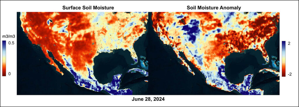
Spire’s Soil Moisture Insights (shown left) and soil moisture anomaly (shown right) on June 28, 2024, depict dry surface soil moisture conditions across much of the central US ahead of Hurricane Beryl’s impacts.
Before and after Hurricane Beryl: Soil Moisture Insights for the US
Hurricane Beryl made landfall near Matagorda, Texas, on Monday, July 8 as a Category 1 hurricane with maximum sustained winds of 80 mph. Widespread damaging winds resulted in power outages to nearly 3 million customers in the US at its peak. The Houston, Texas, area was most significantly affected, with outages lasting for weeks for some.
Flooding occurred along the hurricane’s path, but Spire’s Soil Moisture Insights also highlight some benefits from Beryl.
“Beryl certainly improved the overall surface soil moisture in Southeastern Texas into Arkansas, Missouri, and Illinois as it moved inland,” Spire Meteorologist and Weather Risk Expert Jared Allen said.
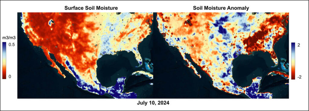
Spire’s Soil Moisture Insights (shown left) and soil moisture anomaly (shown right) on July 10, 2024, depict wetter surface soil moisture conditions across portions of the central US after Hurricane Beryl’s impacts.
“To go from -1.5 or -2 standard deviations to a +1.5 to +2 standard deviations would be significant in only happening with tropical cyclone landfalls or unique heavy rainfall patterns. While not unprecedented, this type of turnaround in soil moisture certainly doesn’t happen often, even for flood-prone Southeastern Texas,” Allen added.
The US Drought Monitor echoes significant changes in dry conditions across areas impacted by Beryl in the two weeks from July 2 to July 16. Notably, within that period, moderate drought conditions vanished across parts of Arkansas, Missouri, and Illinois, with only two small pockets of abnormally dry conditions persisting in northern Arkansas and central Illinois.
“The rainfall, especially in the goldilocks areas on the storm’s periphery, likely mitigated agricultural industry spending by limiting irrigation use for crops and refilling of wells and stock animal ponds and other agricultural needs given how dry it was before Hurricane Beryl,” Allen explained.

Meanwhile, some fields were likely flooded or too wet for tractor access for a week, which may have resulted in some losses where soil moisture was highest.
Soil Moisture Insights for Mexico
The soil moisture signature was more muted across the Yucatan Peninsula, as Beryl crossed the region in a weaker state and the main precipitation core shifted towards the northern coast. After Beryl made landfall near Tulum, Mexico, as a Category 2 storm with maximum sustained winds of 110 mph early on the morning of July 5, rapid weakening occurred as it moved inland across the Yucatan.
Rain and wind brushed the eastern tip of the Yucatan Peninsula as the storm moved through the region, but there were no reports of fatalities or widespread damage. Beryl emerged over the southwestern Gulf of Mexico as a tropical storm with maximum sustained winds of 60 mph that evening.
Spire’s Soil Moisture Insights show the most significant change in soil moisture conditions over the far northeastern tip of the Yucatan Peninsula. The soil moisture anomaly maps before and after Beryl depict a change from -1.5 or -2 standard deviations to a +1.5 to +2 standard deviations in that small zone.
Farther west, soil moisture conditions became drier over an area in the central Yucatan Peninsula, likely signaling the area affected by subsidence, or sinking, dry air after Beryl’s influence. This area of dry soil aligns well with the local precipitation minimum observed. NASA satellite-derived data estimates indicated only 0.05 to 0.20 of an inch of rain fell in parts of the western Yucatan. Additionally, hot and dry conditions typically follow in the wake of many tropical cyclones. Analysis of Spire’s Soil Moisture Insights data depicted the dryness of the soil in this region likely due to these factors.
Despite warm Gulf of Mexico waters and low wind shear, both factors favorable for hurricane intensification, it took some time for Beryl to become more organized again likely due to the weakened storm’s poor organization. When it moved over the Gulf, the low-level center of circulation had become displaced from the upper-level low-pressure area. For tropical systems to become better organized and stronger, meteorologists look for the structure of a storm to be vertically stacked.
Spire Soil Moisture Insights and business applications
Spire Global recently announced its advanced Soil Moisture Insights, leveraging its fully deployed constellation of satellites combined with AI and machine learning technologies. This innovative solution offers high-resolution, precise soil moisture data updated daily, up to a 500-meter resolution. Users can access a comprehensive 40-year archive of soil moisture data worldwide, providing invaluable insights for trend analysis, climate research, and data science applications.
The product is designed for a wide range of users and applications, including risk management in insurance, agriculture commodity price forecasting, drought forecasting, irrigation and crop management for precision agriculture, flood and wildfire prediction, environmental monitoring, construction and civil engineering efforts, hydrological modeling, weather modeling, and as input to a variety of machine learning applications.
The critical role of soil moisture in environmental and economic stability is well recognized, impacting agriculture, water resource management, and environmental hazard mitigation. With global accessibility and effortless integration via an easy-to-use API, Spire’s Soil Moisture Insights empowers businesses, researchers, and government agencies to optimize operations and make informed decisions.