Scale Offshore Wind Operations & Efficiencies With Better Wind Forecasting
Why efficient and scalable offshore wind energy depends on accurate and high-resolution weather forecasts and radio occultation
Leverage accurate, high-resolution wind forecasts to optimize wind energy production
Wind is variable and volatile, which means wind-produced energy will be as well, unless paired with detailed weather forecasts to plan and optimize wind farm operations. This is especially the case with offshore wind energy where the energy production opportunity truly lies. After all, offshore winds blow stronger and more steadily than on land winds while the placement of turbines near coastal, high-population areas can support reduced energy transmission costs while lowering real estate fees.
However, forecasting offshore wind has been a constant challenge for the renewable energy sector. Yet, it’s a challenge that must be addressed. Demand for wind energy is growing—energy output is estimated to have reached 65GW in 2020 worldwide and is predicted to hit 68 GW in 2021—and it’s expected to be a $1 trillion industry by 2040. Without better wind forecasts, the industry will grow in size…but will not reap the full operational and financial benefits it should.
Wind Energy Challenges That Hit the Bottom Line
Predicting wind and weather is likely the single-greatest determinant of a wind farm’s operational success as it influences when power can be generated, how well that power can be integrated into a broader electrical grid, and when the optimum times are for maintenance activities. However, these challenges skyrocket when it comes to offshore facilities.
Knowing When Is The Right Time To Build & Do Maintenance
Offshore wind farm construction comes with a wide range of challenges. Companies must determine when on-shore components should be delivered to their final offshore destination. Then, there’s the development process itself which can include building the basic foundation, connecting the wind farm to the grid, and then construction of the actual turbines themselves. This is a months long, dangerous process. Without being able to identify calm weather periods, wind farm operators could find themselves addressing materials damages and losses that hit their bottom line. Or, even worse, health and safety risks to their workforce.
Of course, once the building is complete, there will always be long-term maintenance required. Just as accurate weather forecasting is needed for a seamless build-out, it’s also needed to keep maintenance truly routine and problem-free.
Moderating Grid Integration In the Face Of Volatile Energy Flows
Ramp events—frontal systems, thunderstorms, and low-level jets—produce wind energy variations that impede seamless power grid integration. They compromise grid operations and can result in major financial fees by way of energy imbalance penalties. Grid operators expect seamless energy production and mette out these penalties when their vendors fail to meet energy production obligations. While energy production volatility is less of an issue with traditional fossil-fuel based production methods, it’s a major burden in the renewables space. Without accurate weather forecasts, wind producers could be faced with harsh penalties again and again.
Why Wind Predictions Regularly Fail
Weather and wind predictions are vital to the offshore wind industry. Yet the limitations of legacy technology make accurate, reliable predictions an ongoing problem.
Buoy-based reporting
Drifting buoys tethered to the ocean floor have been the offshore weather data collection method of choice for the past fifty years. Equipped with environmental sensors and transmission capabilities, they collect air temperature, wind speed and direction, barometric pressure, and other real-time environmental conditions.
However, buoys present a number of weather forecast shortcomings. They can only report on weather conditions at or near the surface. Additionally, almost all tethered buoys are near the coastline. While there are drifting buoys, they are a poor solution when needing weather data about a specific weather location. In all, buoys offer only a limited view of global weather data patterns, and certainly a poor view for open waters.
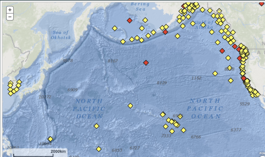
Buoys with meteorological sensors NCDC
Ship-based reporting
In-transit vessels can also serve as weather data-reporting conduits. However, because ships and vessels generally follow established shipping lanes, the data they do report rarely covers remote, lesser-traveled open ocean regions.
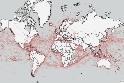
24 hours of AIS data tracks
Other weather forecasting technologies
Of course, there are other methods of weather forecasting including ocean surface based weather stations. However these stations fail to capture the dynamic weather processes taking place throughout the atmosphere that ultimately impact weather at a given place. Further, tools like radiosondes which are tethered balloons launched through the troposphere do an excellent job of collecting vertical weather profiles. However, their tethered nature makes their weather reporting coverage highly limited.
Learn more about GRIB2 weather data for wind turbine applications
For a concrete example of the types of solutions being used by the industry, here’s a Spire Global tutorial on how to retrieve wind forecasts for different altitudes.
Adopting Radio Occultation (RO) for Better Weather & Wind Forecasting
Satellite radio occultation (RO) collects data from bending radio waves transmitted between satellites as they pass through the atmosphere. This process yields information on a diverse set of weather metrics including atmospheric temperature, pressure, and water vapor content.
Unlike legacy weather forecasting solutions, RO provides holistic weather data coverage no matter how remote the region. RO data sets include 3D coverage of an area, with vertical measurements going from the ocean surface to as high as 120 km. Additionally, because RO is satellite-based, weather data readings can be taken across the entire globe. This means RO offers weather forecast data that is more comprehensive, covers greater land and open-ocean areas, and features more real-time data sets than legacy solutions.
In fact, a study performed in early 2020, which compared the accuracy of different weather models in predicting wind speed and direction for a variety of open ocean locations, showed the power of RO accuracy. Wind forecasts produced by the European Centre for Medium-Range Weather Forecasts (ECMWF), the Meteorological Office of the UK (UKMO), and The Global Forecast System (GFS) produced by the National Centers for Environmental Prediction were compared with Spire’s RO-augmented predictions. The charts below show that Spire’s RO-based weather models had the lowest margin of error when predicting wind speed and direction.
Wind speed
Plotted in this chart is the wind speed mean absolute error in knots for Spire, ECMWF, UKMO, and GFS.
Wind direction
This chart shows the comparison of the mean absolute error, this time in degrees, for wind direction.
Achieving Better Offshore Wind Operations
As offshore turbines are increasingly placed further and further from shore to leverage stronger, steadier wind supplies, the need for more accurate, reliable weather forecasting will only grow. Not only do these operations face the classic needs of any wind operation like predicting energy supply and scheduling safe times for maintenance operations but they also come with a new set of challenges based on their deepwater locations.
Built on floating platforms rather than ocean floor foundations, these sites are much more prone to weather fluctuations and increased risks from adverse weather events. Offshore wind operators will need to predict longer time windows for maintenance and construction while adjusting for a higher quantity and volatility of weather variables.
As wind operators seek to optimize all aspects of their business, from minimizing the capital expenditures associated with upfront construction and controlling the operating costs associated with recurring maintenance to safeguarding the safety of all personnel and minimizing energy imbalance penalties, they’ll need to leverage global, near real-time weather data for better forecasting and better overall performance.
 Written by