Spire’s March satellite launch: Accelerating forecast accuracy with optical inter-satellite links
- Why inter-satellite links matter for weather forecasting
- Optimizing efficiency of satellite data transmission
- Expanding capabilities with Polarimetric Radio Occultation
- How OISLs enhance tropical storm forecasting
- Spire's March launch: Expanding capabilities and building our constellation
- Advancing weather and climate intelligence
Meghan Mussoline
Product Marketing Manager, Spire Weather and Climate
In the world of weather forecasting, timing is everything. The fresher the data, the better the forecast.
Spire Global is pushing the boundaries of data latency reduction with its upcoming March satellite launch, featuring cutting-edge optical inter-satellite link (OISL) technology. This launch represents significant advancements in how weather and climate data can be collected, processed, and delivered to decision-makers worldwide.
Why inter-satellite links matter for weather forecasting
Inter-satellite links allow satellites to communicate directly with each other, bypassing the need to wait for a ground station pass to relay data. The result? Faster data transmission, reduced latency, and more timely weather insights.
“Our Radio Occultation (RO) profiles, along with other observational data sources, are used to produce an accurate estimate of the initial atmospheric state for weather forecasting,” said Dr. Vu Nguyen, GNSS Radio Occultation Technical Director at Spire Global. “Observations that are ingested into the model with reduced latency will help produce better initial conditions, which are critical for forecast accuracy.”
The value of low-latency data is even greater for ionospheric forecasting, where conditions evolve more rapidly than in the lower atmosphere.
The ionosphere (the charged portion of our upper atmosphere) changes rapidly, impacting GPS, communications, and radar. To be useful, measurements must arrive within 15 minutes. Inter-satellite links ensure this data is available in time, enhancing space weather monitoring.
“OISLs are necessary to ensure RO-derived ionospheric variables are assimilated into ionospheric forecasting models with maximum impact,” Dr. Nguyen added.
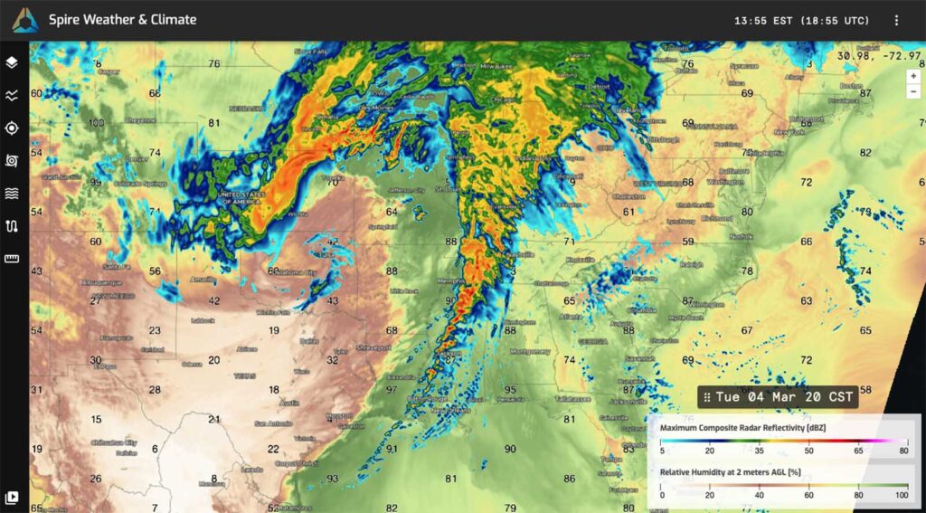
A High-Resolution Forecast snapshot shows predicted composite radar reflectivity and relative humidity, indicating severe weather potential in the Southern US.
Optimizing efficiency of satellite data transmission
One of the biggest challenges in ensuring RO data reaches forecasting models in time is the dependency on ground stations. Satellites must fly over a ground station to downlink data, which means data delivery times can vary. Spire has built a dense global network of ground stations to minimize this delay, but optical inter-satellite links (OISLs) have the potential to provide an even more effective solution. OISLs allow satellites to communicate directly, transmitting data in orbit and reducing the reliance on ground passes. This means weather-critical data could reach models faster, leading to more precise forecasts.
Expanding capabilities with Polarimetric Radio Occultation
One of the satellites launching in March includes Polarimetric Radio Occultation (PRO) capability, which enhances traditional RO measurements by detecting precipitation and cloud properties. Unlike standard RO, which primarily measures atmospheric temperature, pressure, and humidity, PRO can also analyze hydrometeors—such as precipitation rate and type and clouds—by leveraging polarization differences in GNSS signals.
“PRO can be thought of as ‘augmented’ RO,” explained Dr. Nguyen. “These measurements are still sensitive to temperature and water vapor but also provide valuable insights into hydrometeors, offering potential improvements for numerical weather models.”
PRO enhances Spire’s ability to accurately represent cloud microphysics, including moisture distribution, cloud cover, and precipitation intensity. By improving cloud analysis and ingestion during data assimilation, PRO strengthens the accuracy of the Spire High-Resolution Forecast. More precise cloud simulations lead to better forecasts for precipitation, energy balance, surface conditions, and soil moisture.

A satellite image shows Tropical Cyclone Pam churning over the South Pacific Ocean.
How OISLs enhance tropical storm forecasting
Spire’s polar, sun-synchronous orbits ensure global coverage, including key tropical regions where tropical cyclones form. Since these storms develop rapidly, reducing data latency through OISLs could help forecasters detect and predict their evolution with greater precision.
“Sun-synchronous orbits provide global coverage and observations at the same local time. For tropical cyclones, this means being able to observe the formation of a tropical cyclone even in remote areas like the South Indian Ocean or South Pacific Ocean,” Spire Data Assimilation Expert Dr. Sanita Vetra-Carvalho explained. “OISL will allow us to downlink this data faster, especially from locations that are quite remote with fewer ground stations.”
Learn more about our Optical Inter-Satellite Link (OISL) payloads
Spire’s March launch: Expanding capabilities and building our constellation
The March launch will introduce seven LEMUR satellites, each playing a key role in enhancing Spire’s data capabilities. Among them:
- Four Radio Occultation (RO)-capable satellites – These satellites will strengthen Spire’s ability to collect atmospheric temperature, pressure, and humidity data. One of these satellites is also PRO capable, meaning it can measure precipitation and cloud properties.
- Two Optical Inter-Satellite Link (OISL) test satellites – These satellites will test Spire’s ability to transmit data between satellites using optical laser links. By securely transmitting data almost instantaneously across distances up to 5,000 kilometers, OISLs hold the promise of reducing data latency and improving overall data flow within Spire’s constellation.
- One customer payload satellite – Expanding Spire’s Space Services offerings by integrating partner missions into the launch.
Advancing weather and climate intelligence
Spire is scaling up its constellation to meet growing demand for high-quality, low-latency Earth observation data. This includes expanding RO and PRO measurements and integrating Hyperspectral Microwave Sounding (HyMS), which will provide even more detailed atmospheric insights.
PRO utilizes a passive grazing path geometry to detect cloud hydrometeors at various vertical levels, while HyMS provides a more direct active nadir-view perspective beneath the satellite with high vertical resolution. By combining PRO with HyMS, along with geostationary infrared (IR) and visible satellite data, Spire will improve the horizontal and vertical localization of precipitation—leading to more precise, high-resolution weather forecasts.
“Spire will continue to build out its constellation of Earth-observing satellites focused on data quantity, quality, and spatial-temporal coverage,” Dr. Nguyen said.
“Spire’s future deployment of optical inter-satellite links will ensure these data arrive at end users and are ingested into weather forecast models in a timely manner to maximize impact,” he added.
As the need for real-time weather intelligence grows, Spire’s continued innovations will enhance forecast precision and help businesses and governments make better decisions in an increasingly volatile climate.
“With every satellite launch, we’re pushing the boundaries of weather intelligence. The integration of Polarimetric Radio Occultation (PRO) and optical inter-satellite links (OISLs) represent a major step forward in delivering faster, more accurate, and more comprehensive weather data. These advancements don’t just improve forecasts — they empower industries, governments, and communities to make smarter decisions and become more resilient even as climate change fuels more frequent and intense extreme weather.”
Share on Facebook Share on Twitter Share on LinkedIn