Liftoff
7 LEMUR satellites launch on SpaceX Transporter-13 mission
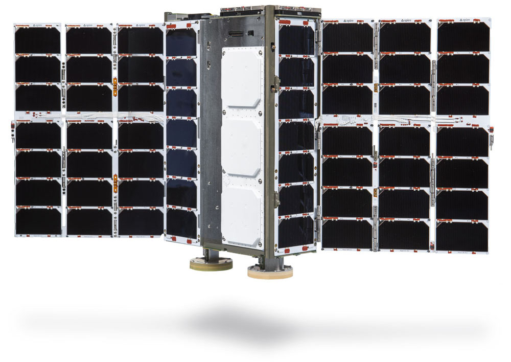
Spire Global will launch seven LEMUR satellites aboard the SpaceX Transporter-13 mission. These multi-payload satellites, ranging in size from LEMUR 3U to 6U, will replenish Spire’s multipurpose constellation and enhance capabilities in space reconnaissance, weather monitoring, and tracking maritime traffic.
Meet the LEMURs
What will these satellites accomplish in orbit?
Optical Inter-Satellite Link (OISL)
Two of the satellites are dedicated to testing Optical Inter-Satellite Links (OISL), a critical technology designed to enhance data speed, security, and resilience. These satellites also feature RF ISL capabilities, RFGL capabilities, and ADS-B capabilities.
Spire successfully established a two-way optical link between two satellites in orbit, marking a significant milestone for secure and high-speed satellite communications. The optical payloads use lasers to transmit data between satellites nearly instantaneously, even at distances of up to 5,000 kilometers. This breakthrough improves applications such as weather forecasting, global communications, and environmental monitoring by reducing latency and enhancing security.
Weather & Climate
One of the satellites features Polarimetric Radio Occultation (PRO) capabilities, enhancing Spire’s ability to detect ice clouds, estimate precipitation intensity, and monitor cloud properties such as thickness and altitude. By analyzing the horizontal and vertical polarization components of GNSS signals, PRO provides deeper atmospheric insights that can improve weather prediction and climate modeling.
Additionally, four of the launched satellites are RO-capable, collecting temperature, pressure, and humidity data globally, including across remote regions and oceans. This data strengthens weather forecasting by improving the accuracy of initial atmospheric conditions in models, leading to more accurate forecasts and long-term climate insights.
Aviation
Spire teamed up with Wingbits to launch an ADS-B payload on one of the satellites. The space-based data collected by the payload will act as a validator to Wingbits’ terrestrial ADS-B data to create a more comprehensive and robust flight tracking system.
“Partnering with Wingbits enables us to integrate data from a next-generation, highly innovative ADS-B network, and combine it with data from our space infrastructure, creating a more comprehensive and robust flight tracking system,” says Philip Plantholt, General Manager and Global Head of Aviation at Spire Aviation.
Space Reconnaissance
Spire continues to build out our space reconnaissance capabilities. This launch increases revisit rates, supporting RF detection customers and enhancing global situational awareness.
Spire operates the world’s largest multipurpose satellite constellation, delivering unmatched radio frequency (RF) intelligence from Low Earth Orbit (LEO). Our solutions provide real-time detection, geolocation, and signal processing capabilities to enhance space reconnaissance operations.
Key Benefits:
- Detect and geolocate RF emissions worldwide
- Identify and mitigate GNSS jamming and spoofing threats
- Enhance maritime security and dark ship detection
- Rapid tasking via API or web console
- In-orbit processing for real-time intelligence
Our RF data and geolocation services empower defense, security, and intelligence organizations with mission-critical insights.
Constellation replenishment
Four of the newly launched satellites are part of Spire’s ongoing constellation replenishment efforts. These satellites will support critical applications, including:
- AIS (Automatic Identification System) tracking for maritime monitoring.
- GNSS-RO (Global Navigation Satellite System Radio Occultation) for weather and climate applications.
- RFGL (Radio Frequency Geolocation) capabilities.
With these additions, Spire increases revisit rates and capacity, further supporting RF detection customers and enhancing global situational awareness.
OISL technology
“Precisely pointing two satellites, across distances equivalent of New York to London, and establishing an inter-satellite optical link is a significant milestone for Spire. This achievement places us among a select group of organizations capable of developing and deploying this advanced technology and overcoming the complexities of aligning satellites separated by thousands of kilometers in Low Earth Orbit. Integrating this technology into our future fleet will enhance resilience, improve security, and reduce latency for critical applications.”
John E. Ward
Senior Director of Research & Development
Spire Global

About Spire’s OISL payload
- Smallest on the market, enabling deployment on small satellites
- Maintains performance levels previously only achievable with much larger systems
- This advancement enhances Spire’s data solutions and provides its Space Services customers with a fast and secure data transfer system
Inter-satellite links play a crucial role in improving data latency. Reducing latency is particularly crucial for mid-latitude coverage and real-time ionosphere monitoring, which impacts GPS positioning, defense communications, and radar systems.
Looking ahead
Spire’s satellite constellation continues to advance the delivery of near real-time space-based data. By integrating cutting-edge technologies such as OISL, PRO, and ADS-B into our existing satellite fleet, Spire is reinforcing its commitment to innovation and data insights from space.
Stay tuned for future announcements as Spire continues to expand its capabilities in space reconnaissance, weather intelligence, and secure satellite communications.
Watch the launch
[TO BE INCLUDED IF LIVE LINK AVAILABLE]