How Spire’s High-Resolution Forecast provided businesses early insights ahead of Hurricane Helene
Meghan Mussoline
Product Marketing Manager, Spire Weather and Climate
Two-thirds of Spire’s High-Resolution Forecasts within three days of Hurricane Helene’s landfall accurately predicted its landfall location within 25 miles.
Additionally, precise wind and precipitation forecasts provided more lead time and bolstered decision-making for businesses in industries like energy, utilities, and commodities.
Recap of Hurricane Helene’s US impacts
Hurricane Helene underwent rapid intensification, becoming a large and powerful storm over the eastern Gulf of Mexico, making landfall as a Category 4 storm with maximum sustained winds of 140 mph, about 10 miles west-southwest of Perry, Florida, at 11:10 pm ET on Thursday, September 26th. It was the first major hurricane to strike the United States in the 2024 Atlantic hurricane season. Helene unleashed a damaging storm surge, destroying 90% of homes in Florida’s Keaton Beach and leaving debris, sand, and rocks piled up and other small Florida beach communities “unrecognizable,” according to the Pinellas County Sheriff’s Office.
The deadly storm’s fast forward motion, massive wind field, and torrential rainfall caused widespread devastation as it moved inland over the Southeastern US. Catastrophic flooding unfolded in the southern Appalachians as 20-30 inches of rain fell. Flash flood emergencies and high-water rescues ensued in Asheville, North Carolina, rural parts of Tennessee, where two dams nearly failed, and Atlanta. Some communities were left entirely isolated by floodwaters as roads crumbled in spots, adding to the recovery challenges.
Helene knocked out power for over 4 million customers, with Florida, Georgia, and South Carolina suffering the brunt of outages. The hurricane’s significant damage caused tens of billions in estimated economic losses, although exact figures are still being assessed.
Helene is the fourth hurricane of the season to make landfall along the US Gulf Coast, and the third hurricane to strike Florida’s Big Bend in 13 months, including Hurricane Debby in August 2024 and Hurricane Idalia in August 2023.
Hurricane Helene by the numbers:
140 mph
maximum sustained wind speeds at landfall (Cat 4)
45 miles
distance from Tallahassee, FL at landfall
4.3 million
power outages at peak
55 mph
wind increase within 24 hours before landfall
30.78 inches
heaviest rain total measured in Busick, NC
99 mph
wind gust in Suwannee, FL
100 mph
wind gust in Alma, GA
$15 billion-$26 billion
property damage estimated by Moody’s
Spire’s early insights into Helene’s eastern track toward Florida’s Big Bend
Spire’s High-Resolution Forecast model accurately predicted Hurricane Helene’s landfall location, timing, and intensity, providing valuable forecasting insights for industries such as energy, commodity trading, utilities, and grid operators. The enhanced model performance contributed to improved operational decision-making, resource allocation, and risk mitigation during this impactful weather event.
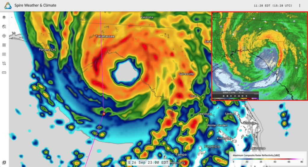
Spire’s High-Resolution Forecast model run initialized at 12z on September 26th, the last official run available before landfall, depicts the composite radar reflectivity as Helene at landfall. The pink line shows the NHC official centerline track. The image in the red box in the upper-right corner shows actual radar as Helene made landfall.
Accurate track forecasts: Within three days of Helene’s landfall, Spire’s forecast accurately predicted Helene’s landfall location within 25 miles in two-thirds of its model runs. Three out of the six final runs came within 10 miles of the actual landfall location, adding even more confidence in decision-making for businesses with operations in Helene’s path.
Spire’s forecasts were consistently east of the NHC’s centerline but still within the cone of uncertainty. Ultimately, Spire’s forecast was spot-on with Helene making landfall east of the NHC’s centerline.
Accurate strength forecasts: Spire’s forecasts accurately predicted Helene’s rapid intensification into a Category 4 storm leading up to landfall, pinpointing high-end winds in northern, central, and western portions of Florida and capturing the storm’s large wind field in the Southeastern US.
Utility impact: Accurate predictions of minimal power outages and wind gusts in the eastern Florida Panhandle helped utilities with resource planning, while Spire’s High-Resolution Forecast precisely indicated the location and intensity of the most damaging winds.
Precipitation: Spire’s High-Resolution Forecast model accurately predicted extreme rainfall (up to 30 inches) in the southern Appalachians days in advance, providing early insights into flooding threats and emergency management response needs.
Spire’s High-Resolution Forecast model identified potential rainfall extremes 24-36 hours earlier than other models, allowing for more effective messaging regarding flood risks and providing earlier guidance for flood preparation measures. Spire’s model was in 99th percentile of Quantitative Precipitation Forecast (QPF) distributions among multiple models analyzed, which turned out to be the correct forecast.
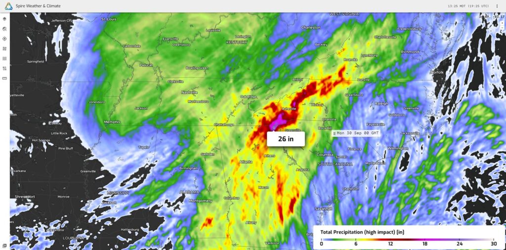
Spire’s High-Resolution Forecast model run initialized at 12z on September 24th, two days ahead of landfall, depicted rainfall amounts from 26 inches to locally 30 inches of rain in the southern Appalachians.
Why did Spire forecasts perform better?
Spire’s extensive satellite network plays a vital role in closing critical weather data gaps, particularly in hard-to-reach regions such as remote areas and over vast ocean expanses. This proprietary data provides reliable initial weather conditions, a crucial factor in increasing the accuracy of forecasts.
Spire’s Radio Occultation (RO) technology allowed for more comprehensive sampling of atmospheric conditions, especially over the oceans. This capability improved the forecast accuracy regarding the forces steering Hurricane Helene. RO technology is a revolutionary method that retrieves vertical profiles of the atmosphere, much like data from weather balloons. However, unlike traditional balloon launches, which are manual, expensive, and limited to land-based operations, RO is automated, scalable, and globally accessible.
Spire’s High-Resolution Forecast offered critical insights into Hurricane Helene’s trajectory toward Florida’s Big Bend well ahead of other models. The high-resolution model forecasted Helene’s exact track and landfall location with remarkable precision, enabling timely decisions across sectors like energy and utilities.
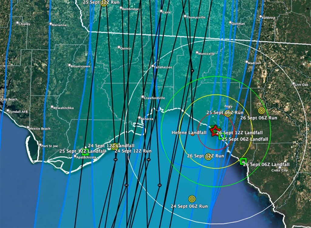
The last six Spire High-Resolution Forecast model runs for the continental US (September 24th initialized at 06z through September 26th initialized at 12z) landfall locations (green squares), model positions at September 27th at 03z (yellow targets), all NHC official centerline tracks (black lines), and 10 mile (red), 20 mile (yellow), 30 mile (green), and 50 mile (white) range rings surrounding the official landfall location (red star). September 27th 03z modeling positions were captured as that was the official landfall time of Helene.
Spire’s network of satellites achieves this precision by analyzing signal distortions from GPS/GNSS satellites caused by atmospheric factors. This results in unparalleled global coverage, delivering essential weather data from polar regions to remote oceanic locations, helping fill the significant gaps that exist in traditional observation methods.
Hurricane Helene rapidly intensified leading up to landfall and wobbled to the right in its final hours over the Gulf of Mexico, which presented challenges in precisely predicting landfall and the location of Helene’s greatest wind impacts. In addition to superior initial weather data, Spire’s High-Resolution Forecast model offered deeper insights into fine-scale atmospheric processes, proving invaluable for those managing risk in the face of such a powerful storm.
High-resolution forecasting models are essential for capturing detailed atmospheric interactions, such as convection and ocean surface processes, that determine the intensity and movement of hurricanes. Spire’s model brought a new level of clarity and accuracy to forecasting Hurricane Helene, providing significant value to industries that rely on precise weather data.
“As shown by our forecasts of Hurricane Beryl and Helene, Spire’s High-Resolution Forecast model excels at forecasting tropical systems,” Dr. Tom Gowan, Spire Director of Weather Prediction and AI, said. “The assimilation of our proprietary data, including RO, accurately initializes storms over the open ocean, while the fine grid spacing of our model enables the small-scale processes that govern hurricane development, track, and strength to be resolved. Ultimately, this results in forecasts with world-leading accuracy that enables communities and companies additional time to prepare for the devastating impacts of hurricanes.”
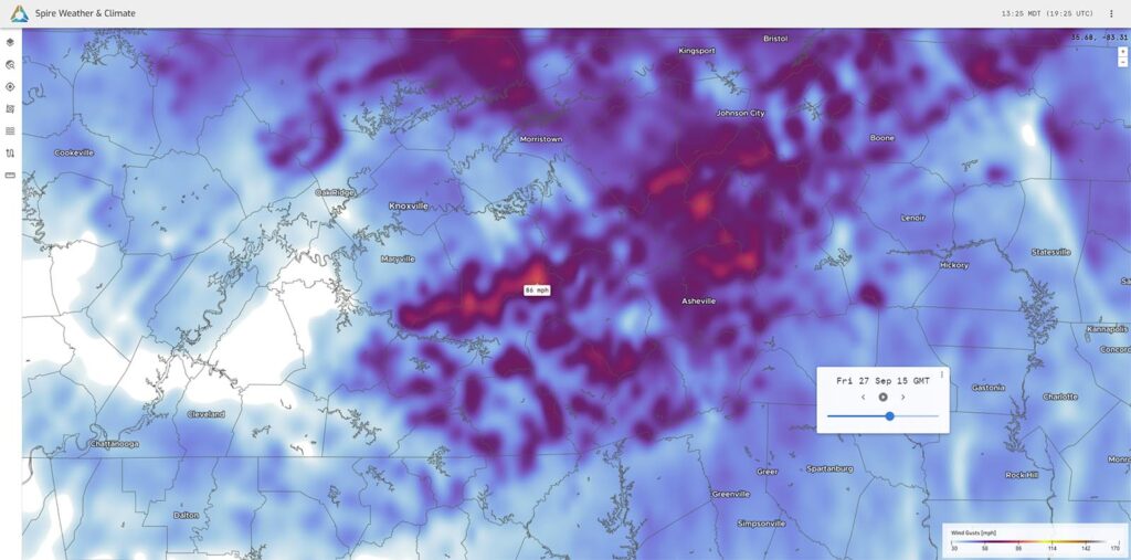
Spire’s High-Resolution Forecast model run initialized at 12z on September 24th, two days ahead of landfall, depicted hurricane-force wind gusts across the southern Appalachians.
Conclusion and key business takeaways
Spire’s High-Resolution Forecast model proved to be an invaluable tool in the accurate prediction of Hurricane Helene’s landfall, wind speeds, and precipitation. The model’s ability to provide early, accurate forecasts allowed businesses in industries like energy, utilities, and commodities to make informed, confident decisions. Spire’s superior performance demonstrated the model’s robustness and reliability, making it a key resource for enhancing operational efficiency and mitigating the impacts of severe weather events.