Behind the forecast: How Spire predicted Hurricane Milton’s landfall with unmatched accuracy
Meghan Mussoline
Product Marketing Manager, Spire Weather and Climate
Spire’s High-Resolution Forecast model accurately predicted Hurricane Milton’s landfall location south of Tampa Bay with more than three days of advanced notice.
Recap of Hurricane Milton’s Florida impacts
Hurricane Milton made landfall as a Category 3 hurricane, packing maximum sustained winds of 120 mph, near Siesta Key on October 9th. It had a large wind field as it struck Florida, unleashing damaging hurricane-force winds across central parts of the state, and causing 3.3 million power outages. Excessive rainfall north of its path caused flooding, with river flooding continuing more than a week after the hurricane’s onslaught.
The major hurricane left a path of destruction, killing at least 30 people, just two weeks after Hurricane Helene’s blow. Damages have been estimated at up to $34 billion by CoreLogic, although specific figures are still being assessed.
Storm surge of up to 10 feet occurred in Sarasota County, Florida, but fears of catastrophic storm surge in Tampa Bay did not play out since the storm struck south of the region, as accurately predicted by Spire. The landfall south of Tampa Bay reduced storm surge risk in vulnerable, heavily populated areas, likely saving tens to hundreds of millions of dollars in damages.

On its track toward Florida, Hurricane Milton underwent rapid intensification more than once. It strengthened to Category 5 hurricane strength twice while over the Gulf, joining the ranks of notorious hurricanes that have achieved that status more than once in the Gulf: Camille in 1969 and Allen in 1980. At peak intensity, the hurricane had maximum sustained winds of 180 mph and a central pressure of 897 mb (26.49 inches of mercury).
In the hours leading up to landfall, Milton began to weaken due to dry air and wind shear, but it remained a dangerous major hurricane. As it approached Florida and moved onshore, Hurricane Milton was a prolific tornado producer, with National Weather Service (NWS) offices issuing 126 tornado warnings on October 9th. At least 43 tornadoes have been confirmed by NWS offices in areas affected by the outbreak.
The Melbourne NWS office confirmed 19 tornadoes touched down, making it the largest tornado outbreak in the office’s 35 year-history. The Tampa Bay NWS office confirmed nine tornadoes touched down, and the Miami NWS confirmed 15 tornadoes struck.
Milton was the third hurricane to make landfall in Florida this season and the fifth hurricane to make landfall along the US Gulf Coast in 2024.
Hurricane Milton by the numbers:
180 mph
maximum sustained winds at peak (Cat 5)
120 mph
maximum sustained winds at landfall (Cat 3)
43 miles
distance from Tampa, FL at landfall
2x
Milton reached Cat 5 strength over the Gulf
92 mph
Milton’s greatest wind increase within 24 hours
3.3M
power outages in Florida
43
confirmed tornadoes due to Milton
3,000+
flight cancellations caused by Milton
102 mph
gust at Sarasota Bradenton International Airport
Spire accurately predicted Hurricane Milton’s landfall and impacts
The Spire High-Resolution Forecast model provided valuable insights into Hurricane Milton’s landfall, strength, and related impacts. The model successfully predicted the landfall position and high-end wind gusts with a high degree of accuracy, allowing businesses to properly allocate resources, make smart decisions, and mitigate risks.
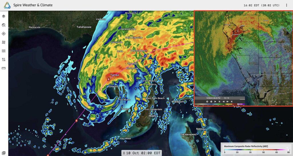
Spire’s High-Resolution Forecast model run initialized at 12z on October 7th, more than two days ahead of Milton, depicted the composite radar reflectivity at Milton’s landfall. The pink line shows the NHC official centerline track at the time. The image in the red box in the upper-right corner shows actual radar as Milton made landfall.
Accurate track forecasts: Within three days of Hurricane Milton’s landfall, two-thirds of Spire’s forecasts accurately predicted its landfall location within 30 miles. Half of the model’s forecasts came even closer within 20 miles of the actual landfall location, adding even more confidence in decision-making for businesses with operations in Milton’s path.
Additionally, Spire’s forecasts were consistently south of Tampa Bay ahead of other models and the National Hurricane Center’s centerline track.
Accurate strength forecasts: The Spire High-Resolution Forecast accurately predicted Milton’s major hurricane strength at landfall and the scope and intensity of the most damaging winds, helping electric companies properly allocate resources and reduce downtime.
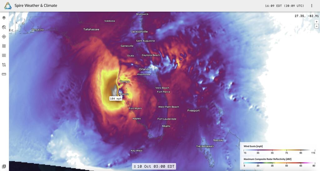
Spire’s High-Resolution Forecast model run initialized at 12z on October 7th, more than two days ahead of Milton, depicted hurricane-force wind gusts expanding across central Florida at landfall. The forecast shows tropical-storm-force winds extending well beyond that, as was witnessed when Milton hit.
By correctly identifying areas at highest risk, utilities improved response times by up to 30% and reduced average downtime by 20-40%, compared to previous years without similar forecasting tools. Additionally, Spire’s forecast accuracy helped save millions in operational costs by pre-positioning repair crews in the right locations, avoiding costly delays in emergency response efforts.
A wind gust map at 1:30 am ET October 10th captured from DeepVision™, our premier weather risk solution.
Precipitation: Spire’s High-Resolution Forecast model predicted extreme rainfall (more than 16 inches), with a high degree of accuracy, especially from northeast of Orlando to Daytona Beach, providing advance notice on flooding threats and emergency management response needs. Spire’s model was in the 90th percentile of Quantitative Precipitation Forecast (QPF) distributions among multiple models analyzed in the Daytona Beach area, correctly pinpointing amounts.
Why did Spire forecasts perform better for Hurricane Milton?
Spire’s satellite network helps close weather data gaps, particularly in remote areas and over oceans. This proprietary data provides reliable initial conditions, boosting forecast accuracy.
Using Radio Occultation (RO) technology, Spire captures detailed atmospheric data, especially over the oceans, which significantly improved predictions of the forces steering Hurricane Milton. Unlike traditional, limited weather balloon launches, RO is automated and globally accessible, delivering continuous, scalable insights.
Spire’s High-Resolution Forecast predicted Milton’s track and landfall with remarkable precision, allowing sectors like energy, utilities, and power trading to make timely decisions. The model’s superior performance was also due to its ability to capture fine-scale atmospheric processes.
Spire’s model provided early insights into Milton’s weakening ahead of landfall due to dry air and wind shear, demonstrating the critical value of high-resolution forecasting in capturing intricate atmospheric interactions that drive hurricane intensity and movement. High-resolution models can better capture the dynamics and physics, resulting in better and more detailed forecasts.
“Our forecasts of Hurricane Milton once again highlight the accuracy of Spire’s High-Resolution Forecast model,” said Dr. Tom Gowan, Spire Director of Weather Prediction and AI. “The integration of proprietary data and fine grid spacing allows us to capture the small-scale processes that define a hurricane’s track and intensity.”

Conclusion and key business takeaways
Spire’s High-Resolution Forecast model proved essential in accurately predicting Hurricane Milton’s landfall, wind speeds, and rainfall. Businesses across energy, utilities, and power trading were able to make informed decisions with confidence. Spire’s advanced satellite data and Radio Occultation technology enabled more accurate insights into Milton’s path, intensity, and impacts, setting it apart from other models.
The model’s reliability and precision not only enhanced operational efficiency but also mitigated risks. Spire’s forecasts for Hurricane Milton once again demonstrated the model’s ability to deliver world-leading accuracy in the face of severe weather, proving it a critical resource for managing hurricane impacts.