Climate change, future economy & civilization: How organizations are leveraging space to support ambitions
- Introduction
- Earth observation, from the first view of the Earth from a satellite to improving life on Earth
- Wildfire mitigation: Satellite based thermal imagery as the first line of defence
- Wildfires: Size of the problem
- How can satellite constellations in space help mitigate wildfires?
- Why, for Spire, firefighting from space is just the tip of the iceberg
 Written by
Vividha Chopra
Product Marketing Manager
The adoption of space-based data is very much on the rise.
Alongside widely reported examples that include the increased provision of Internet from satellites via constellations in Low Earth Orbit from private operators such as Starlink and OneWeb, or the earth observation data used to monitor the impact on global food supply chains detrimentally impacted by the invasion of Ukraine, there are a growing number of use cases appearing and not just in the Business to Consumer market. The Business to Business market too, is seeing a rise in the use of space-based data, with companies looking to the sky as they seek new ways to provide actionable insight or more efficient services for their clients.
Satellite constellations are no longer the exclusive domain of government-level initiatives, but are available to any company with a plan for including space to enhance their business model, in the same way that the companies once looked to leverage the dawn of the internet to boost their productivity. Blue chip firms like Apple and John Deere are just two examples of the multitude of organizations, large and small, that are already using satellite constellations as a method of delivering new data sets and tools that can enhance the way they do business.
The perception that space technology is expensive and unattainable is changing, as satellites are helping improve companies’ bottom lines by driving efficiencies through the supply chain with insights that are global, real-time, and accurate. These efficiencies cause a positive ripple effect throughout the operations of a business, helping them save and earn revenue, but also better spend their time and resources.
All of this provides a simple answer to the question of why on Earth should a business care about space – ultimately, the best companies will evolve as access to technology changes. To stay relevant and continually provide the best service to customers, successful entrepreneurs would be missing a huge opportunity if they did not refine, rework or at least start the development of a space strategy for their business.
Although the daily use of satellite data tends to be focused on communications and navigation, one of the fastest-growing ways that space can support businesses, the economy, the environment, and wider society is through Earth Observation intelligence. The kind of image-based insight that can be used for tracking maritime patterns, or tracking aviation patterns, can also be used for some of the most innovative applications imaginable.
It is this exciting and yet still relatively untapped data source (in terms of the number of companies yet to discover how useful it can be to any business model) that we will explore in this article, with examples of how one company, in particular, has embraced space to drive new opportunities in its area of expertise.
Earth Observation, from the first view of the Earth from a satellite to improving life on Earth
Before we look more into where we are going, let’s first take a look back. After many experimental satellites were orbited and when the first operational observation of the Earth from a satellite was captured from the weather satellite, TIROS-1 in 1960, no one could have anticipated that vastly more capable technology would be packed into the contemporary 6U-sized satellite. Packed into a fraction of the size of the early satellites, Spire’s satellites replace the grainy, low-resolution imagery of decades past, with the ultra-sharp, ultra-high-resolution images of today. These images can even be processed using machine learning and AI. From images showing the tracking of weather patterns from space, to today’s high-quality, actionable insights to support climate science, far faster, far smaller, and far better.
The Earth Observation satellites used for meteorology and photography of the Earth in the early 1960s were the forerunners of today’s Earth Observation industry, which is now helping to tackle some of the most pressing problems around the globe, such as the destruction caused by what seems like an increasing number of wildfires every year. Their early identification and monitoring of their progression is most effectively carried out from space, allowing fire crews to be deployed with maximum effect, fully informed on each situation thanks to the ability to predict the fire’s movements and support disaster relief efforts from the ultimate vantage point – a “bird’s eye” view from space.
Wildfire mitigation: Satellite based thermal imagery as the first line of defence
Two companies at the forefront of an environmental and business support effort are Spire Global and thermal intelligence data experts, OroraTech.
At Spire we allow our customers to quickly and cost-effectively deploy and scale their own constellation of nanosatellites with minimum risk and resource by utilizing Spire’s ‘build, launch, and operate’ capabilities and expertise. Our pioneering space organziation leverages over a decade of experience developing our own proven space data platform, together with a global ground station network, end-to-end manufacturing facility, and extensive launch partnership network, to roll out solutions at pace for clients that need space insight.
OroraTech is an international global intelligence-as-a-service company and long-term Spire partner, who have developed the technology to provide insights around wildfire monitoring and thermal data collection. Founded in Munich, Germany, the innovative company has revolutionized wildfire detection by establishing a comprehensive global monitoring network, delivering real-time situational awareness and prompt risk alerts.
In creating their space strategy, OroraTech recognized that information from satellites would provide them with the global coverage they needed for their service, allowing them to react faster to detect wildfires at the earliest stages while finding a cost-effective way to drive forward the technology development of their sensors. At the same time, they needed not only to be able to identify and monitor fires but also to ensure a robust, secure, and swift mechanism to send the data collected back to analysts who could turn that information into actions. Actions that could not only save their customers money, natural capital, and belongings, but could save lives too.
Leveraging datasets from space was the perfect solution for enhancing the impact of OroraTech’s technology and the ability to take a ‘new space’ approach to an age-old problem was key. As a young company focusing resources in key areas, it could not expect to use traditional, government space missions, or afford to rely on large satellites built by aerospace ‘Primes’ and come with lots of costs and even more waiting times. In Spire, they found a dynamic partner that could move quickly due to having done most of the heavy lifting already – all that was needed was the addition of OroraTech’s payload.
In the words of OroraTech’s Chief Commercial Officer, Dr. Axel Roenneke:
“We worry about our customer’s needs and giving them the best performance. We don’t need to worry about the launch or how the satellite platform operates”
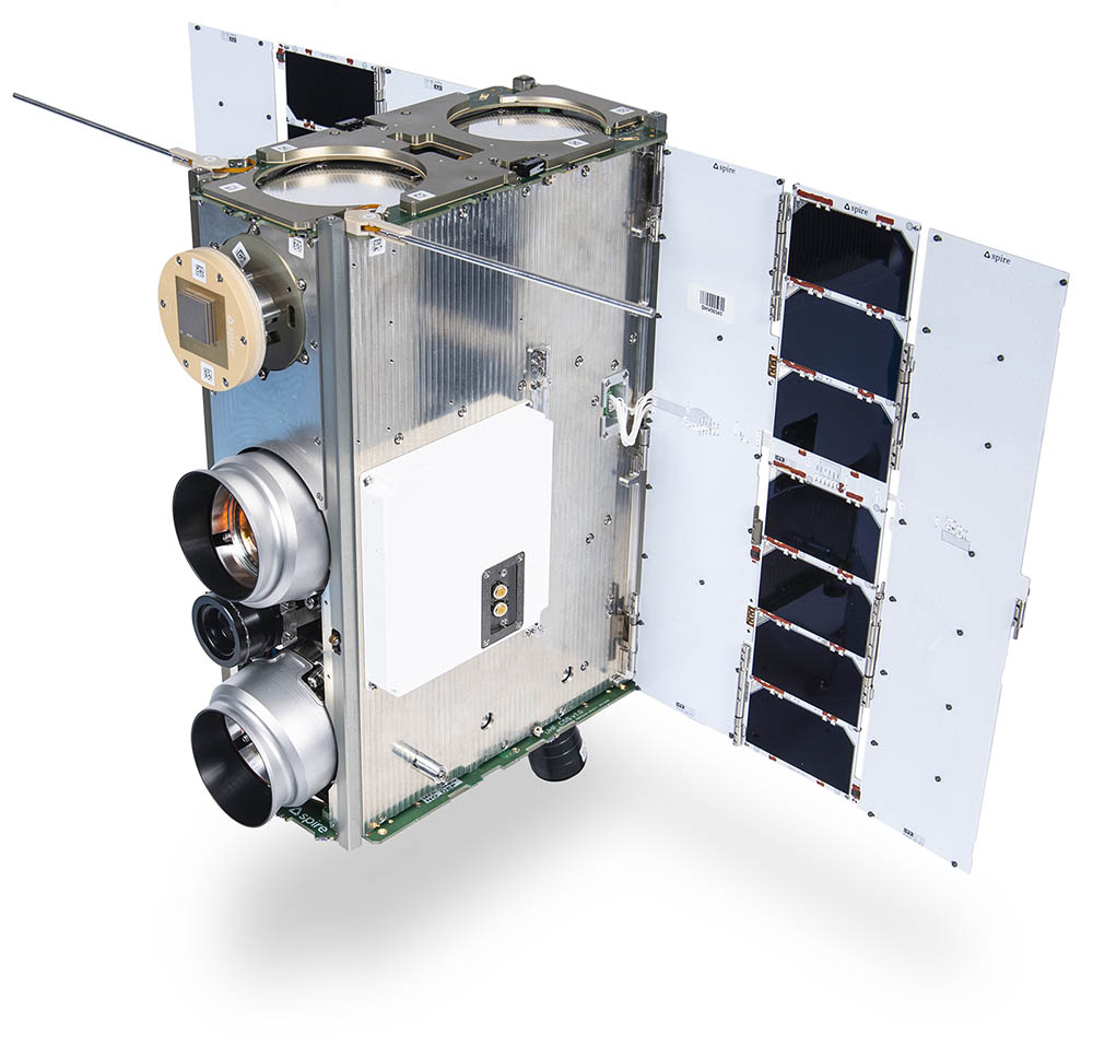
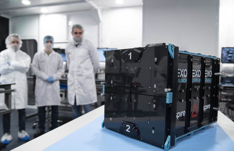
This is FOREST-2, OroraTech’s 6U Spire-built CubeSat carrying an improved thermal imaging camera. The OroraTech constellation of 8 satellites will be comprised of duplicate spacecraft using this technology. It will be the first-ever solution in space at the constellation scale that captures wildfires globally at their inception, therefore increasing mitigation response time and ultimately saving lives and the environment.
Wildfires: Size of the problem
Wildfires are a topical, dangerous, and expensive problem all over the world. The area burned in the US by wildfires appears to have increased each year since the1980s (EPA). DBRS Morningstar estimates that the Canadian wildfire-related insured losses in Q3 will amount to between $700 million and $1.5 billion. DBRS said that wildfires have been particularly widespread this year, affecting most Canadian provinces and burning through 14 million hectares of land (Reinsurance News). Perhaps it’s no surprise that the Canadian Space Agency has prioritized this issue, recently turning to Spire and OroraTech to help develop solutions for mitigating the problem.
While the long-term remedy would be to halt climate change (or even reverse it, if at all possible), the immediate challenge is to identify and fight fires as soon as possible. Spire and OroraTech enable achieving this from space with considerable effectiveness.
OroraTech, who have quickly secured their position as the industry leader in space-based thermal data intelligence, recently appointed Dr Axel Roenneke as their Chief Commercial Officer. His extensive industry knowledge and leadership experience will be instrumental in driving OroraTech’s future growth and expanding its climate intelligence-as-a-service offering into new markets such as insurance, utilities, agriculture, and geospatial.
Dr Roenneke further explained, “I’m looking at how to scale up OroraTech, which has been developing these amazing products to manage wildfires and to help manage climate change. We are going at a very strong pace now.”
With so many countries searching for ways to combat this continual problem, and so many communities, business supply chains, and natural ecosystems impacted, the demand for OroraTech’s expertise and detection capabilities is growing.
How can satellite constellations in space help mitigate wildfires?
The detection of wildfires and forest security more generally is often undertaken by ground assets including human observation, cameras on towers, aircraft, and more recently, Internet of Things sensors. But these are far less flexible and visually capable than satellites, as well as coming with huge associated safety risks, logistical issues, and both installation and maintenance costs, in many cases. On average, wildfires spread at about 15mph, but in strong winds and ideal conditions they can spread faster than a car can be driven away. Wildfires on the Hawaiian island of Maui recently demonstrated this, leaving those impacted with very little time to escape with their lives, let alone their possessions (NPR).
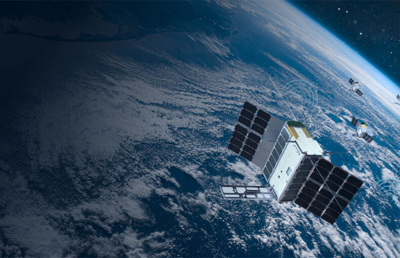
In the early days of satellites, the revisit cycle was low, so it could take days to have a second look at a specific area. Today, with many nanosatellites in a wide range of low-Earth orbits, constant observation is possible and companies like Spire specialise in multi-satellite constellations that can facilitate any payload requirements from innovative firms like OroraTech.
Dr Roenneke stated, “With our Wildfire Solution customers gain situational awareness at their finger tips, globally, across countries and continents, without sacrificing response time or accuracy. This can only be done with a sensor network in space. A satellite-as-a-service provider helps us do this cost efficiently.”
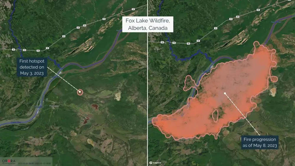
An example of a recent fire that emerged near Fox Lake, Alberta, captured on May 8, 2023, via OroraTech’s Wildfire Solution. Left image: The detection of the first hotspot on May 3, 2023. Right image: The fire progression after five days of burning (OroraTech)
Why, for Spire, firefighting from space is just the tip of the iceberg
Spire’s heritage and reliance on its own fleets is what attracted OroraTech to the firm. We currently have more than 100 satellites in orbit, while operating over 30 ground stations. Our company has conducted 30-plus launch campaigns in ten years and has over 780 customers in 65 countries and counting. But perhaps most interestingly and reassuring for customers like OroraTech, Spire is the number one user of its own platforms. The company has a division that provides data insights itself, meaning it relies on the same infrastructure services and solutions that it provides for partner missions.
Joel Spark, co-founder of publicly listed Spire Global Inc. and is its Chief Satellite Architect, explains:
“There is an attitude that space is going to help businesses in the future. That’s not the case. Space is already here.”
“The average US citizen uses about 47 unique satellites every day. The rate of technology advances and cost reductions in satellites is absolutely staggering, compared with achievements on the ground. It’s a fascinating time to be in the industry. It’s gone from an extremely expensive, exquisite service to sometimes being the only way to face some challenges.”
“We can put our customer’s assets in space as we did with the OroraTech camera. Or it can be a pure application (customers can upload novel applications to our software-defined radio). Or we can provide a total end-to-end satellite.
“We take them from the idea to their application being deployed in orbit. They have direct control over their payload through an API, very similar to how you would deploy your cloud infrastructure with a server with Amazon. It’s explicitly built to scale. They can operate it manually up to about 10 satellites, but it’s designed on an API basis to operate with your back-end business logic.” added Spark.
When it comes to demonstrating how space benefits life on Earth and harnessing these benefits commercially, Spire’s successful collaborations with its multitude of private and government clients act as a catalyst to inspire future generations of innovative space development, delivering the kind of missions that matter most.
The company was started 11 years ago to improve life on Earth using data from space, before realizing that in addition to offering data insight, it had become perfectly suited to helping others develop their own missions for Spire to execute through its design, build and launch experience.
Today, the message from every single member of the Spire Space Services team is clear – “Every company needs a space strategy” and businesses all around the world today can be separated into two categories; those who have one and those who need one.
This logic has become a mantra for our firm, as we seek to inform other industries about what satellite-based tools they can draw on to further any business and solve any Earth problem.