Hurricane Hilary: Severe flooding, weather warnings, and heat
 Written by
Andrew James
Resident Journalist
The first hurricane to hit the U.S. this year is taking an unusual course and approaching the United States off the West Coast.
Hurricane Hilary will bring heavy rain across Southern California, Nevada, and Arizona. This has led to a first-ever Tropical Storm Watch for the West Coast, flood warnings, and will lead to knock-on effects across the United States.
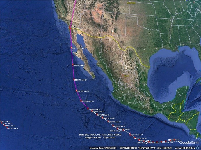
A map showing Spire’s data forecasting Hurricane Hilary’s route towards California
National Hurricane Center issued the first ever Tropical Storm Watch for the West Coast of the United States for Hurricane Hilary as it barreled towards California.
Hurricane Hilary made landfall in California as a tropical storm over the weekend, making it the first tropical storm to make landfall in California in nearly 84 years – and only the third ever recorded, according to data from NOAA, says CNN.
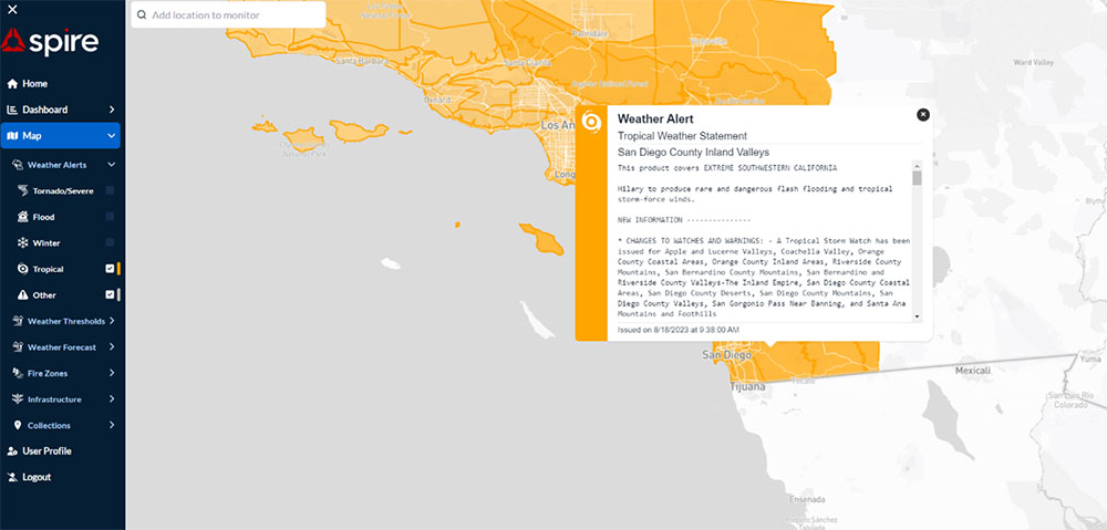
Spire’s DeepVision™ Dashboard showing the NHC’s first ever West Coast Tropical Storm Watch.
The hurricane slowed to a Tropical Storm before hitting Southern California with heavy rains and flooding after making land. and meeting the cooler waters off the coast of California. It’s now moving inland as a low pressure zone.
What does it mean for you?
The mid-troposphere low pressure over the West Coast and the ridge of high pressure in the plains allowed this storm to come North. As well, the current heat wave warnings for the Midwestern United States will become more extreme and have the potential to put a strain on energy grids as staying indoors and air conditioning will be necessary. Spire’s DeepVision™ dashboard is already showing heat warnings for the energy grid in Texas and heat warnings across the Midwest.
The remnants of Hilary will likely ride the ridge Northward into Canada and help to develop a cold front that will help to move that ridge out and bring a bit of heat relief to the Midwest by late next week into next weekend, according to Levi Blanchette from Spire’s Weather Risk Team.
The National Weather Service in Phoenix, Arizona has issued the following High Risk rain warning:
Anomaly measures from NAEFS mean output are still off the charts, and almost unbelievably more extreme than previous iterations. Essentially every standardized field measure is pegged at a climatological extreme for this time of year at multiple time scales. Most impressive is IVT measuring better than 14 normalized standard deviations from average and rivaling anything experienced in moisture flux during the cool season. Considering a large reservoir of 2.0-2.5″ PWATs will be tapped by a 60-70kt meridional wind in the H8-H7 layer, this poleward moisture advection persistent through the Saturday night through Monday morning time frame should bring recurring periods of moderate to heavy tropical rainfall to the western CWA. RAW GEFS output still highlights extreme accumulations across SE California with almost no members below 1″ in El Centro and greatest clustering in a 2-5″ range. If data for Palm Springs is indicative of surrounding higher elevations around Joshua Tree NP, almost no member advertises anything under 2.5″ with the best clustering in a 4-7″ range. Thus, it comes as no surprise that WPC has painted a rare High Risk in the excessive rain outlook (ERO) along the western CWA border during the Sunday morning through Monday morning time frame.
Hurricane Hilary was a Category 4 storm, with recorded winds up to 65 Knots (almost 75 mph). It’s now a low pressure system heading inland.
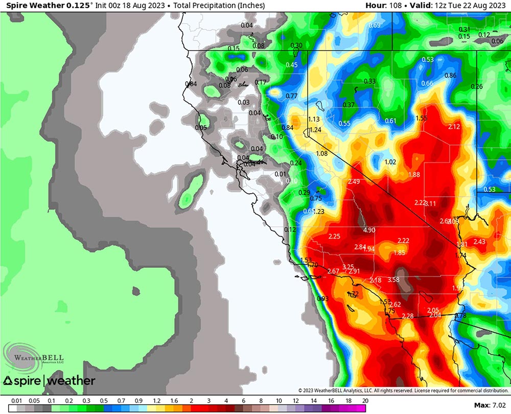
The Spire Weather data is showing up to 7.02 inches of rain in Southern California for early next week
Impact on infrastructure
As noted above, the storm is causing flooding, and an associated increase in the heatwave will put strain on energy grids. Spire’s ShipView dashboard showing cargo ships (red) and tankers (black) taking a wide course around the Category 4 storm on Friday.
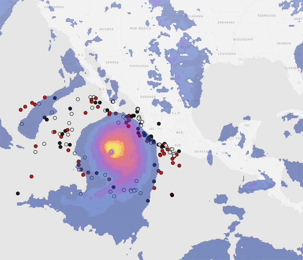
Spire Weather‘s Wind Gust data layered over Spire Maritime’s ShipView data showing cargo (red) and tanker (black) ships taking a wide course to avoid Hurricane Hilary on Friday.
Inland, Spire’s DeepVision™ dashboard shows weather warnings around electricity grids and base stations across the U.S.
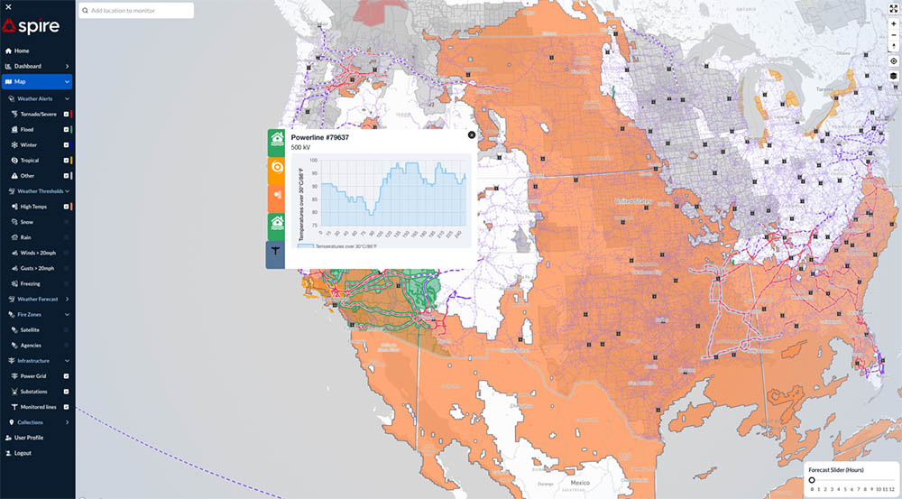
A map of the U.S. from Spire’s DeepVision™ dashboard showing weather warnings around power grids in Nevada on Friday.