A White Christmas for Colorado?
While the term ‘white Christmas’ sounds self-explanatory- snow on the ground or snowing on Christmas Day- the National Weather Service in the US does have a formal definition of what constitutes a white Christmas, for the purposes of record keeping.
A white Christmas is formally defined as there being at least 1 inch of snow on the ground on the morning of December 25th, this means that the best chances of having an “official” white Christmas, is to have snow fall in the lead up to Christmas, or overnight on Christmas Eve.
The probabilty of a white Christmas in Colorado
Across Colorado, the highest historic probability of seeing an official white Christmas is across the Rocky Mountains, where the probability is near 100%, and westward all the way to the Colorado-Utah state line. East of the mountains, including Pueblo, Colorado Springs, Boulder, and Denver, the chances of a white Christmas are lower, ranging from 10-25% in southeastern Colorado to 25-50% in central and northeastern Colorado.
The last white Christmas in Colorado
Christmas 2022 was the first white Christmas in 5 years for Denver, with 2″ of snow on the ground on Christmas morning. However, this was a case where no snow fell on Christmas Day itself, or even Christmas Eve. The snow that was on the ground Christmas Day had actually fallen mostly overnight between December 21st-22nd. The high temperature that day was well above freezing at 49 degrees.
A white Christmas in 2023?
Currently, it appears the Christmas 2023 may have an opportunity for a second white Christmas in a row for the Denver area, with snow potentially falling on both Christmas Eve and into Christmas Day itself, although the best chances look to be from Saturday, December 23rd and into Christmas Eve. Two storm systems are expected to work their way into Colorado over the weekend, and while there is uncertainty in how they might interact with each other, it is currently expected that snow will fall over portions of western Colorado and the mountains through the weekend.
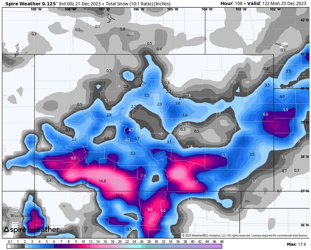
Total snowfall expected through the weekend as of the morning of Monday, December 25th
Whether this activity will bring snow into the foothills and the plains is still uncertain, however confidence is growing in the potential for at least some snow in the urban areas, with different models bringing impacts from the weather system to different parts of the state. Temperatures through the remainder of the week preceding Christmas are quite seasonably warm, with highs through Saturday expected to be above freezing. If the ground retains that heat, it could limit how much snow is able to accumulate before melting, or if temperatures are slow to fall, could even result in more of a wintry mix event, with a mix of both snow and rain falling.
The different weather models have struggled to come into a consensus over precipitation chances and snow totals overall, keeping the highest snowfall over the mountains and western Colorado. The Spire model however has gradually increased the amount of snowfall anticipated through the weekend in the lead up to Christmas, with 1-3″ now forecast around the Denver area, however this may not be the total accumulation due to the warmer temperatures in front of the weather systems, that could result in any initial snowfall melting as it reaches the ground.
Overall, who in Colorado will see a white Christmas is still fairly uncertain. Certainly, across the highest elevations where snow has already fallen, and is unlikely to melt before Christmas, the official definition is likely to be met, and it looks likely that these systems will bring additional snowfall to parts of the state, but where exactly that additional snow will fall, how much will fall, and how much will accumulate is still fairly low confidence.
Whether the larger metro areas see an official white Christmas is especially uncertain, but there is a increasing chance of at least a few snow showers in and around Denver and Boulder, and further south towards Colorado Springs and Pueblo in the lead up to Christmas, even if less than an inch is on the ground Christmas morning.
 Written by