Understanding multilateration (MLAT) for more precise aircraft positioning free from interference
 Written by
Tjasa Pele
Digital Marketing Specialist
In recent years, the aviation industry has faced an alarming surge in disruptions to navigation systems due to Global Navigation Satellite System (GNSS) interference, jamming, and Global Positioning System (GPS) spoofing.
According to the International Air Transport Association (IATA), interference rates surged by 175% between 2023 and 2024, while GPS spoofing incidents spiked by a staggering 500% year over year.
Despite backup systems designed to mitigate these risks, such disruptions pose a significant threat to flight safety and efficient air traffic operations. Given the growing concerns over GNSS vulnerabilities, multilateration (MLAT) has emerged as an indispensable component in modern aviation. By being a GNSS-independent system, MLAT ensures robust and resilient aircraft tracking.
What is multilateration (MLAT)?
Multilateration (MLAT) is a method that determines the location or position of an object by measuring the difference in arrival times of signals transmitted from the object and received by multiple satellites or ground stations. Unlike GPS, which relies on Time of Arrival (TOA) of satellite signals, MLAT uses the Time Difference of Arrival (TDOA) method to triangulate positions accurately.
The core principle of MLAT in aviation is straightforward: an aircraft’s transponder emits signals that are received by multiple strategically placed satellites or ground stations at slightly different times due to varying distances. By analyzing these time differences, the system triangulates the aircraft’s precise position. This makes MLAT highly resistant to GNSS interference as it does not depend on external satellite signals that can be jammed or spoofed. As such MLAT offers real-time surveillance independent of onboard navigation systems that strengthens air traffic surveillance, enhances flight operations, and improves situational awareness for air traffic controllers, military defense systems, and search-and-rescue operations.
How does MLAT work?
MLAT operates through a coordinated network of strategically placed satellites or ground stations that collect, process, and compute aircraft positioning data. The process includes the following steps:
- Signal Transmission: Aircraft equipped with transponders (Mode S or ADS-B) continuously broadcast signals.
- Signal Reception: Multiple satellites or ground stations receive the transmitted signals at slightly different times.
- Accurate timestamping: Each satellite or ground station precisely records the arrival time of the signal.
- Position Computation: The system calculates the aircraft’s position by analyzing the time differences between the received signals at various satellites.
- Data Integration and Display: The computed position data is then transmitted to air traffic control (ATC) systems and integrated with radar and ADS-B data for enhanced situational awareness.
- Continuous Tracking: The MLAT system continuously processes new signals to update aircraft positions in real time, ensuring accurate and dynamic tracking.
Application of MLAT in aviation
As GNSS interference incidents become more frequent and pose increasing risks to flight safety, MLAT has become an indispensable method for modern aviation surveillance. Its accuracy, cost-effectiveness, and independence from GNSS make it a critical tool different sectors and for different use cases, among which the most important are:
- Air Traffic Control (ATC) and surveillance
- Enhanced ADS-B coverage and redundancy
- Search and rescue operations
- Military and security applications
Air Navigation Service Providers (ANSPs) integrate MLAT to enhance situational awareness and supplement traditional radars. Regulatory bodies such as the Federal Aviation Administration (FAA) and Eurocontrol employ MLAT into their surveillance networks to improve aircraft tracking in both terminal and airspace, improving operational efficiency and safety.
While Automatic Dependent Surveillance-Broadcast (ADS-B) is a key component of modern air traffic surveillance, MLAT provides an additional verification layer, ensuring seamless tracking even in non-radar airspace. This is crucial for enabling global coverage also over the regions where ADS-B infrastructure is limited or unreliable.
MLAT plays a crucial role in search and rescue missions by accurately pinpointing distress signals from aircraft emergency locator transmitters (ELTs) or transponders. This capability significantly reduces response times and enhances recovery efforts for downed or missing aircraft.
Defence and security agencies utilize MLAT to passively track non-cooperative aircraft, such as unidentified or suspicious flights. This enhances national security, border surveillance, and military defence operations.
Advantages of using space-based MLAT in aviation
Compared to traditional aircraft monitoring methods, space-based MLAT offers several key benefits:
- Safety of operations: MLAT is GNSS-independent and thus not susceptible to jamming or interference from electronic warfare.
- Cost-effectiveness: space-based MLAT provides worldwide coverage and requires significantly less infrastructure than radars, reducing operational and maintenance costs.
- Enhance coverage in challenging environments: space-based MLAT extends surveillance to areas with limited radar coverage, including mountainous terrain, remote regions, and offshore airspace.
- Seamless integration: space-based MLAT complements terrestrial ADS-B and primary radar systems, improving overall air traffic management.
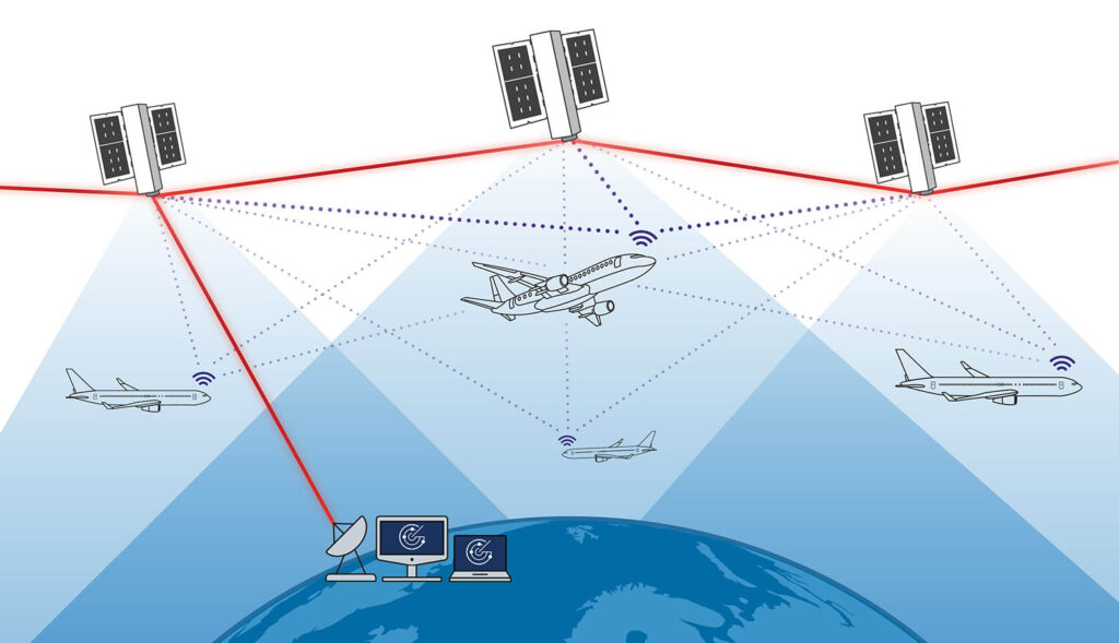
Leveraging space-based MLAT with EURIALO next-generation space-based surveillance constellation
The EURIALO project is set to revolutionize global air traffic surveillance by deploying an advanced space-based MLAT constellation. With increasing threats to GNSS-reliant aircraft tracking, EURIALO introduces a cutting-edge solution that enhances air traffic monitoring even in remote and contested airspace.
EURIALO aims to launch a constellation of low-Earth orbit (LEO) satellites equipped with advanced Mode S and ADS-B signal reception and MLAT technology. These satellites will continuously receive aircraft transponder signals with their advanced antenna arrays and provide the data to ground-based station. From different signal transit time between the aircraft and the various satellites, the intersection point will be calculated to precisely determine aircraft positions, independent of GNSS. To ensure real-time data transmission, the satellites will establish direct and uninterrupted communication between themselves and ground stations using intersatellite links (ISL) and ground links, and thus minimize tracking gaps.
Conclusion
As global aviation faces increasing challenges from GNSS interference and evolving security threats, MLAT is proving to be a vital and resilient technology for aircraft monitoring. Its ability to provide real-time, interference-resistant positioning enhances aviation safety, operational efficiency, and national security.
The EURIALO project takes this advancement even further, integrating MLAT with space-based technology to create an unparalleled aircraft tracking system. By leveraging a constellation of LEO satellites, EURIALO will ensure cost-effective seamless, reliable and uninterrupted global coverage that surpasses traditional monitoring systems. It will not only strengthen air traffic surveillance but also mitigate the growing risks posed by GNSS vulnerabilities. As aviation continues to evolve, MLAT and EURIALO together represent a forward-looking solution for a safer and more efficient global airspace.