Why growing maritime traffic is killing your business
 Written by
Emily Cooper
Contributing editor
Maritime traffic and HTZs have an impact on profit margins for anyone working in the Maritime industry. A gap in AIS data prevents you from fully tracking the timing of your vessel to port.
As maritime traffic increases, tracking vessels becomes more important for many reasons. At Spire, we refer to High Traffics Zones as HTZs. A HTZ is an area where there is excessive maritime traffic due to a high number of vessels utilizing the route or a narrow passageway. In these areas, many ships are transmitting outside of the range of terrestrial collection and satellite collections are dealing with heightened message collision issues. Busy maritime traffic areas include the North Sea, the Gulf of Mexico, and seas bordering China, and Singapore. Maritime companies spend millions of dollars investigating AIS data gaps and lose cargo revenue due to unreliable forecasting annually and the number of areas considered HTZs around the world is growing. These maritime traffic zones represent significant challenges to ship operators, port authorities, government organizations, and commodity brokers.
HTZs have an impact on profit margins for anyone working in the Maritime industry. A gap in AIS data prevents you from fully tracking the timing of your vessel to port, impacts route decisions which cost money in the way of fuel economy and effect the basic laws of supply and demand preventing you from being able to reroute your ship if many other vessels carrying the same cargo are nearing certain ports.
The South China Sea is quickly becoming the most crowded shipping route in the world and to complicate the already crowded waterways is the high volume of small fishing boats that are at risk of colliding with larger vessels. These waterways are also considered a conflict region and are a militarized zone which increases the need to know where ships are throughout their journey.
New Solution for Data Gaps
Spire offers a new solution to the gaps in AIS vessel coverage, Enhanced Satellite AIS which is combined with two other types of AIS collection (Terrestrial and Satellite) into one service. In a 24-hour period sample, we delivered 56% more messages and 25% additional unique MMSIs in the South China Sea. Maritime intelligence and data analytics customers called the results groundbreaking.
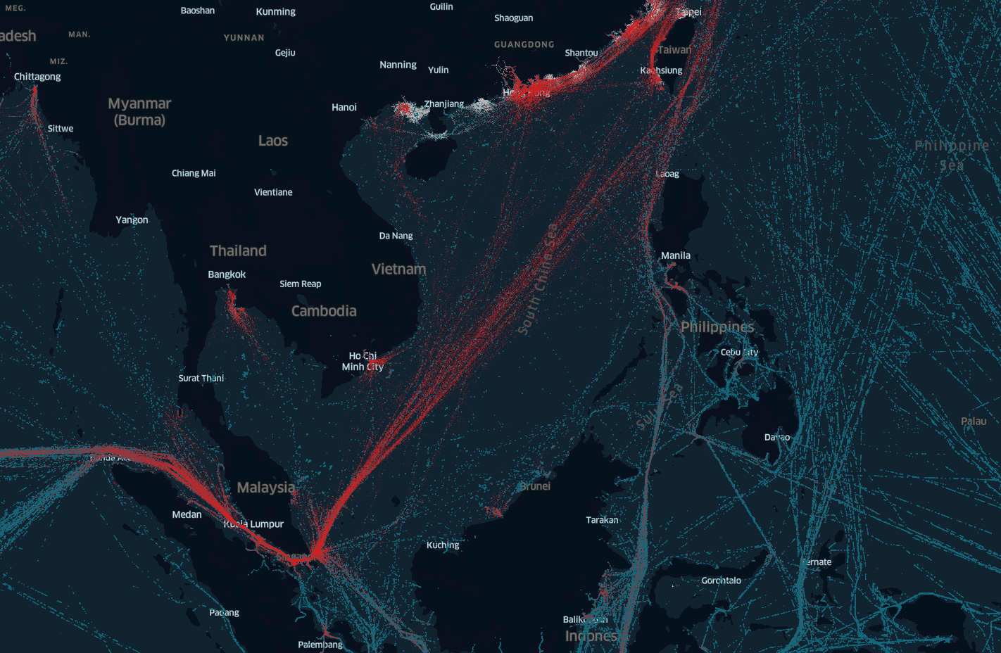
Spire’s Enhanced Satellite AIS in South China Sea
How it Works
Our more than 1,500 satellite-enabled AIS receivers track vessels and the maritime traffic within 60 nautical miles and send this data to communication satellites. This process occurs at least every 15 minutes. We plan on growing our satellite-enabled AIS receivers to nearly 2,000 by the end of this year.
The true value comes when layering S-AIS, T-AIS, and Enhanced Satellite AIS and delivering it in one service. This means you benefit from unprecedented volumes of MMSIs in HTZs through a simple API integration or raw data feed.
Download a free Enhanced Satellite AIS sample.
The Benefits
Spire solutions, including Enhanced Satellite AIS, allow maritime executives the ability to make informed decisions regarding vessel operations to maximize revenue. The solution uses predictive analytics and weather forecasting to optimize fuel consumption, port traffic, and other factors affecting vessel revenue. Our data takes the guesswork out of vessel tracking and provides seamless data about your vessel’s journey– even in heavy maritime traffic.
Easy-to-Use, Fully Supported, and Completely Customizable
Contact us today for more information on Enhanced Satellite AIS , and our data analytics solutions. Our sales team can provide you with easy-to-use data that is tailored to the needs of your business and fully supported by Spire Maritime.
New, Premium Data Samples
Spire also offers industry-focused, premium data set downloads. These data samples are tailored to specific industries – oil, fishing, dry bulk, container, and liquid gas vessel tracking. Our premium data sets are an easy way to experiment with our data and see first-hand the impacts data and predictive analytics can have on your business. Contact us for more information about our data, services, and resources, we’re always happy to help.