Spire Maritime and Freightflows harness machine learning and historical AIS data for accurate predictive analytics
Spire Maritime collaborates with Freightflows to explore the fundamentals of Machine Learning (ML) in the maritime industry, the important role of historical Automatic Identification System (AIS) data in ML models, and how Spire’s extensive AIS data enriches predictive analytics across various industries.
Machine Learning in the maritime industry
Machine learning, a subset of artificial intelligence, employs data sets and algorithms to mimic human learning processes. Three key components—decision process, error function, and method optimization process—drive ML models to make accurate predictions or classifications.
Historical AIS data is the foundation of ML models in maritime. Historical data, split into training and testing sets, equips ML models to distinguish vessel movement patterns and refine decision-making. The principle of “quality in, quality out” is critical with machine learning data sets—the better the quality and quantity of training data, the higher the predictive accuracy. With the most complete historical AIS vessel tracking data dating back to 2010, Spire Maritime data serves as a robust foundation for predictive analytics.
Spire Maritime’s Historical AIS data finds ML utility in various sectors such as:
- Predictive Maintenance in Shipping: Leveraging historical AIS data to predict vessel maintenance needs, curbing downtime, and costs.
- Optimal Route Planning: Analyzing AIS data for efficient vessel routes, trimming voyage time, and slashing fuel consumption.
- Emissions Tracking: Identifying high-emission vessels to comply with environmental regulations.
- Commodity Trading: Anticipating market changes and making informed decisions.
- Supply Chain Optimization: Identify bottlenecks and inefficiencies, enhancing supply chain efficiency.
- Marine Insurance: Risk assessment, fraud detection, and determining appropriate premiums.
AIS Data requirements for ML models
To make AIS data effective in ML models, it must meet specific criteria. Spire Maritime provides over 10 years of historical AIS data, ensures extensive global coverage, enhancing data quality. The data includes vessel identification, positional information, speed, course, and dynamic parameters, enabling detailed analysis.
The data is available in multiple formats, offering flexibility in delivery, including one-time CSV file delivery and API solutions. Dedicated support teams assist users, ensuring a seamless experience.
Freightflow’s bottom-Up approach to data
Freightflows utilizes a bottom-up approach, to gain more accuracy and visibility into commercial markets and specific trades. While top-down approaches rely on government reports and customs information, Freightflows builds its data set from the ground level, starting with Spire Maritime’s AIS data due to its extensive coverage and detailed ship-level information.
The study showcases the process of building a geospatial data set using AIS data. This involves organizing, grouping, and enriching the information, providing visibility into ship behavior and commercial trade dynamics. The emphasis is on creating dynamic polygons for a more nuanced understanding of ship activities.
Dynamic polygons
Dynamic polygons in maritime analytics are flexible representations of specific areas in the sea that adapt based on observed ship movements. Unlike static polygons, which have fixed boundaries, dynamic polygons evolve dynamically, providing a more accurate reflection of current maritime activities. These dynamic representations are crucial for understanding ship behaviors within ports and terminals, allowing for detailed analyses of movements between polygons. The adaptability of dynamic polygons is particularly useful in scenarios where traditional, fixed boundaries may miss significant data points, such as in regions with varying maritime activities. Freightflows utilizes dynamic polygons, built on AIS data, to enhance the granularity of their predictive analytics, offering a more responsive and nuanced approach to studying real-time trade dynamics in the maritime industry.
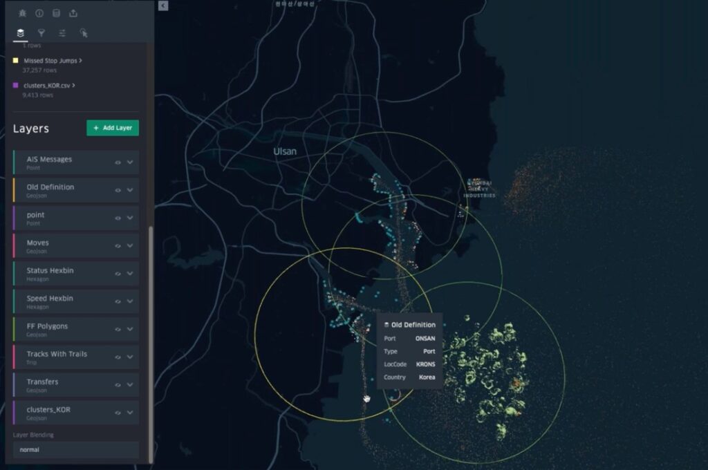
Dynamic polygons representation to understand ship behaviours at the ports and terminals
Freightflows employs advanced techniques in analyzing AIS data, focusing on the categorization of vessel statuses and speeds. This strategic approach enables the identification of heavily trafficked areas, such as anchorage and terminal zones, important for understanding port and berth activities.
A key concept introduced by Freightflows is transfers, providing an average of how ships move within a port. This data facilitates the identification of nuanced differences between berths, leading to the creation of highly dynamic and reproducible port and berth polygons.
Leveraging the Spire Maritime’s Historical AIS data, Freightflows constructs a dynamic geospatial dataset that combines every anchorage area, port, terminal, and berth globally.
Understanding ship movements near New York using clusters
The visualization of New York serves as an example, highlighting the dynamic nature of the dataset crucial for representing maritime activities accurately. These areas faced challenges with long lineups and static anchorage area representations. Utilizing Spire’s Historical AIS data, Freightflows adjusted anchorage areas by creating clusters, revealing specific ship movements, and creating a detailed historical dataset processed by ML. This approach simplifies decision-making for port management.
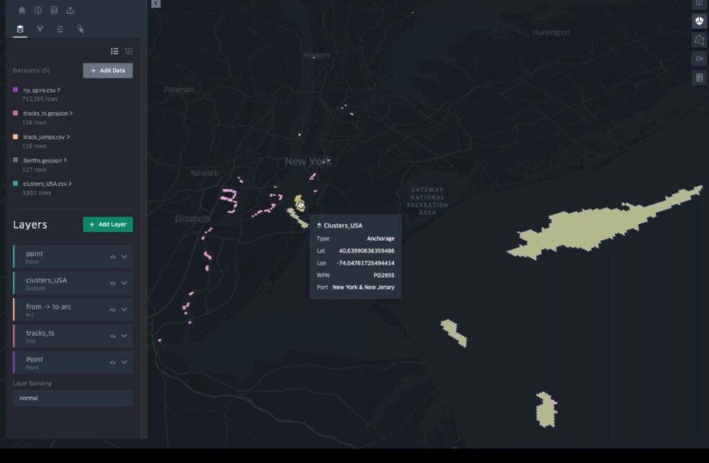
Clusters near New York to improve decision-making for port management
At the ship level, Freightflows conducts behavioral analytics by examining vessel movements between created polygons. This granular analysis informs a historical dataset of vessel movements, providing a detailed understanding of ship behavior and movement patterns.
Leveraging Spire Maritime’s Historical AIS data to train ML model
Analyzing the historical vessel movement from Spire Maritime’s Historical AIS data, the company demonstrates how the dataset allows for the analysis of ships’ previous activities based on berth polygons. Insights from past movements enables predictions about future ship movements. The dynamic clustering and analysis contribute to accurate representations of ship activities.
Freightflows emphasizes the criticality of a strong data foundation, combining Historical AIS data, proprietary port and geospatial foundations, and additional alternative data. This comprehensive approach enables Freightflows to produce actionable insights into global trade activity and commercial context. The insights extend beyond vessel movements to include cargo loading and unloading, terminal operations, and trade activity predictions, focusing on near-term predictions for current business decisions.
The predictive dataset supports strategic use cases such as fleet management, cargo fixing, and exploring new trade routes. The granularity of the data allows customers to tailor its usage based on their specific business needs.
The fusion of Spire Maritime’s historical AIS data with predictive analytics reshapes maritime decision-making and offers a unique and actionable perspective for diverse industries.