Not all AIS data is equal: How to identify and ensure AIS data quality
- Unique MMSI counts and the critical role of Satellite AIS in ensuring comprehensive maritime coverage
- Managing the volume of data: the importance of balanced downsampling
- How data source and associated coverage area define AIS data latency
- Redetection rate: ensuring continuous vessel detection throughout the vessel's entire journey
- Assessing port coverage
- The importance of extensive Historical AIS data
- Delivering high-quality AIS through flexible delivery methods and tailored data-cleansing services
- Learn more about Spire Maritime's AIS data sets
 Written by
Gregory Batavier
Senior Marketing Manager at Spire Maritime
Originally designed as an anti-collision tool, the Automatic Identification System (AIS) has, over the past two decades, evolved into a comprehensive data collection and analysis system.
The collection and use of quality data are essential for any organization, whether commercial or governmental. Making significant decisions without quality data is like shooting in the dark, and this is no different for the maritime industry. Every stakeholder in the wider maritime sector relies on AIS data for critical functions such as vessel tracking, route optimization, fleet management, port operations, environmental protection, and many other use cases. But not all data is equal when it comes to quality. As data-driven decisions move to the forefront of any organisation, understanding how to assess and ensure the quality of AIS data becomes paramount.
While a high volume of AIS messages might seem to indicate high data quality, it only represents one small aspect of the overall data quality picture. Therefore, data quality should be assessed by considering multiple factors such as coverage, latency, and the re-detection rate of vessels, rather than focusing solely on the sheer quantity of data. Spire Maritime, a leader in maritime data, has launched over 175 satellites, harnessing the world’s largest multi-purpose constellation for data collection. This robust infrastructure, leveraging two constellations, provides global, real-time AIS coverage, ensuring comprehensive and consistent data on vessel movements, including in remote and oceanic regions lacking Terrestrial AIS.
Trent Fulcher, CEO of Starboard Maritime Intelligence, describes Spire’s data quality like this: “The accuracy, the availability, and the redundancy of the data feeds we get from Spire Maritime, these elements are really critical in Starboard’s ability to provide a robust and trusted service.”
Watch the full testimonial:
Unique MMSI counts and the critical role of Satellite AIS in ensuring comprehensive maritime coverage
Global AIS coverage is essential for maintaining continuous and comprehensive maritime situational awareness. As hinted previously, while the volume of AIS messages and vessels tracked might seem like indicators of data quality, they are not always reliable measures.
The volume of AIS messages isn’t necessarily proportionate to their value. For instance, Terrestrial AIS may capture the majority of messages, but these signals typically represent vessels within 40 nautical miles of the coastline, leaving those farther out undetected. The count of unique MMSI numbers detected, representing the number of distinct vessels tracked over a given time period, is a key metric that reflects the breadth of coverage.
However, this metric can be inflated by MMSI misuse or errors, potentially distorting the actual coverage extent. Relying solely on a single source of AIS data like Terrestrial AIS for vessel tracking can be problematic. Gaps in AIS coverage, due to the lack of Satellite AIS data, can lead to significant blind spots, undermining the ability to track vessels accurately and posing risks to navigation safety, security, and operational efficiency.
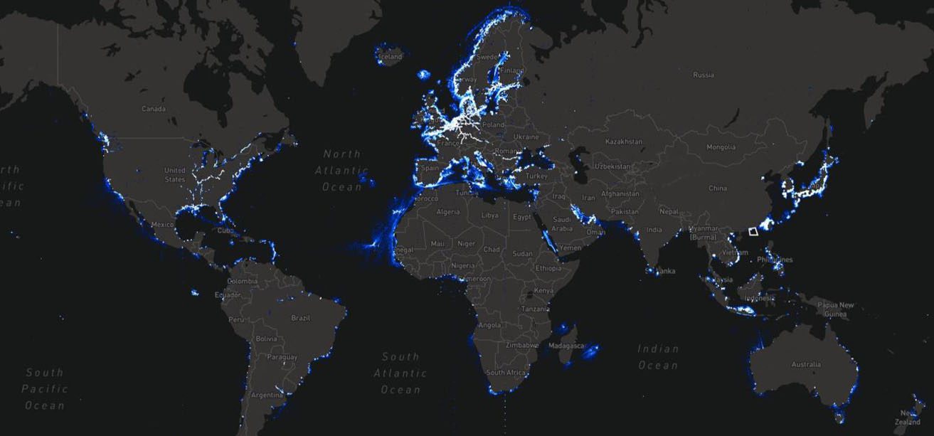 Terrestrial AIS data
These maps illustrate the strengths of Satellite AIS data, showing its comprehensive coverage of vessel routes compared to the limitations of relying solely on Terrestrial AIS data.
Furthermore, Enhanced Satellite AIS utilizes advanced satellite technology to expand coverage beyond the capabilities of traditional Satellite and Terrestrial AIS systems. It effectively captures AIS signals from highly congested High Traffic Zones (HTZs), such as the South China Sea, the North and Baltic Seas, the Gulf of Mexico, and busy ports, ensuring that no vessel goes untracked and significantly reducing undetected AIS messages. In dense shipping areas, such as HTZs, where signal congestion and message collisions often impact data quality, Enhanced Satellite AIS excels by delivering up to 115,000 unique MMSIs and providing an additional 65 million AIS messages daily, thereby overcoming the limitations of traditional AIS data collection methods.
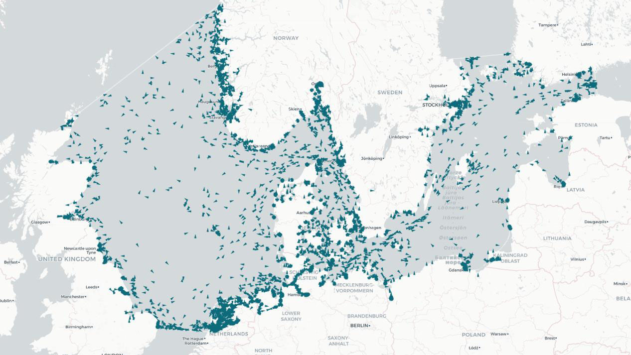 Satellite AIS data
These maps illustrate the uptick in vessel detection from Enhanced Satellite AIS, showing vessels detected by Satellite AIS in blue and vessels detected by Satellite and Enhanced Satellite AIS in red.
Managing the volume of data: the importance of balanced downsampling
Downsampling AIS data involves reducing the dataset to a single measurement per unit time, such as one or five minutes, which is crucial for managing the volume of data while preserving key patterns and trends, making data from different sources comparable for qualitative aspects. For example, due to the sheer number of Terrestrial AIS messages available, these can be downsampled within e.g. 5-minute periods based on MMSI and message type. If multiple position messages from the same MMSI are received within seconds, each individual message does not contribute significant new information. In such cases only the last message would be used, whereas messages received e.g. 7 minutes apart would all be included. Properly applied, as done by Spire Maritime, downsampling allows stakeholders to focus on meaningful patterns and trends, though the sampling rate must be carefully balanced to avoid missing important changes or losing the benefits of downsampling. Overall, this approach enhances the clarity and usability of AIS data, while also reducing the complexity and costs associated with its storage. These improvements support more effective decision-making and analysis.
How data source and associated coverage area define AIS data latency
Latency refers to the delay measured as the difference between the message’s reception and the time it is available to users.
Terrestrial AIS provides near-instantaneous updates; however, this speed is limited by its restricted coverage, typically extending only 40 nautical miles from shore. Consequently, vessels traveling beyond this range remain untracked, leading to incomplete and potentially misleading data. Satellite AIS, however, overcomes this limitation by offering consistent, global coverage. This means that, unlike terrestrial systems, Satellite AIS ensures that updates are not only timely but also encompass the entirety of a vessel’s journey. Therefore, the reliability of AIS data is more accurately reflected in its comprehensive global reach rather than just its speed of update.
For major shipping lanes, the Enhanced Satellite AIS coverage provides a median latency of 11 minutes. While this latency is higher than Terrestrial and Real-time Satellite systems, it offers a significant advantage by covering key routes where accurate and timely AIS data is essential.
Furthermore, Real-time AIS from Spire Maritime provides continuous vessel positions with a median latency of under one minute, as shown in the table below, regardless of location, from the open oceans to coastal areas. This immediacy, made possible by an interconnected satellite architecture that ensures real-time coverage, enables stakeholders to maintain an accurate and current understanding of maritime activities, which is crucial for timely decision-making, especially in dynamic environments where conditions can change rapidly.
| Coverage area | Data source | Median latency (in minutes) |
| Coastal areas (~40nm) | Terrestrial | <1 |
| Major shipping lanes | Enhanced Satellite | 11 |
| Global | Standard Satellite | 48 |
| Global | Real-time Satellite | <1 |
Redetection rate: ensuring continuous vessel detection throughout the vessel’s entire journey
The Redetection Rate per Time Interval (RRpTI) is a crucial metric for tracking maritime vessels, measuring how effectively a system can consistently detect the same vessels over time. RRpTI calculates the percentage of vessels detected within a specific time interval (e.g. 15 minutes) that are redetected in the subsequent interval, expressed as the ratio of vessels redetected to the total number initially detected. For instance, if a vessel is detected between 0:00 and 0:15 and is again detected in the subsequent interval from 0:15 to 0:30, it is considered a successful redetection, contributing to the RRpTI. A high RRpTI ensures consistent vessel monitoring, enabling real-time tracking and reducing the risk of losing a vessel’s location due to signal gaps. Conversely, a low RRpTI can lead to blind spots, making it challenging to maintain an accurate picture of vessel movements, which can compromise decision-making and response times in critical situations.
As an illustration of this metric, we followed two vessels on their respective journey from Shanghai to Rotterdam (vessel 1) and from Rizhao to Houston (vessel 2).
| Vessel 1 | RRpTI rate |
| Terrestrial AIS only | 30% |
| Satellite and Terrestrial AIS combined | 50% |
| Real-time Satellite AIS | 79% |
| Vessel 2 | RRpTI rate |
| Terrestrial AIS only | 9% |
| Satellite and Terrestrial AIS combined | 24% |
| Real-time Satellite AIS | 74% |
For both vessels tracked, a significant improvement in consistent tracking and redetection is observed when Satellite AIS is added to the data feed, compared to using Terrestrial AIS alone. Real-time Satellite AIS leads to an even more substantial increase in reliability and redetection accuracy than relying solely on Terrestrial AIS.
Assessing port coverage
Port coverage refers to the ability to track vessels within port areas, a critical aspect for effective port operations and logistics management. This metric is typically measured as the percentage of baseline port traffic captured, providing insight into how well the system monitors vessel movements within these crucial zones. However, a key limitation is that the baseline for port traffic could be set too low, potentially leading to inflated results and an overestimation of actual coverage. Ensuring an accurate baseline is essential for reliable port coverage assessments and maintaining the integrity of operational and logistical planning.
When considering port coverage, the quality of AIS data also depends on the sources used. The table below illustrates that relying solely on Terrestrial AIS offers the lowest coverage for both ports and MMSIs. Adding Satellite AIS data enhances coverage, while combining Terrestrial, Satellite, and Real-time AIS achieves the highest percentage of MMSI coverage reported in ports. This underscores the importance of using multiple AIS sources to enhance data accuracy and extend port coverage in maritime operations.
| AIS sources | Number of ports | Avg. MMSI coverage |
| Terrestrial AIS only | 2406 | 78% |
| Satellite and Terrestrial AIS combined | 2881 | 80% |
| Real-time, Satellite and Terrestrial AIS combined | 2952 | 85% |
The importance of extensive Historical AIS data
Having access to the largest global historical AIS database on the market, with data dating back to 2010, is invaluable. This extensive archive, only available through Spire Maritime, provides a comprehensive view of maritime activity, allowing for detailed analysis of shipping patterns, vessel behaviours, and maritime trends spanning more than a decade. Such a vast historical dataset enhances the ability to understand and predict long-term changes and anomalies in maritime operations, offering a rich context that cannot be obtained from shorter-term data alone. This depth of historical information ensures that any analysis or decision-making is grounded in a thorough understanding of past conditions and trends, which is crucial for accurate forecasting and strategic planning.
Delivering high-quality AIS through flexible delivery methods and tailored data-cleansing services
While high-quality AIS data is crucial for accurate maritime monitoring, the manner in which this data is delivered plays an equally vital role. Spire Maritime’s flexible API solutions ensure that users can access both real-time, near real-time, and historical AIS data in the format that best suits their needs, whether it be JSON, CSV, or NMEA format AIS messages as transmitted. We offer a range of delivery methods tailored to diverse use cases, including TCP streaming, GraphQL APIs, and REST APIs with OGC-compliant WFS and WMS standards. This versatility in delivery not only enhances the accessibility of high-quality data but also supports its effective integration into various applications, ensuring that users receive timely and actionable information to make informed decisions.
Gary Lloyd, Chief of Architecture and Strategy at 90POE, stated, “When we reviewed the different sources of data we found that Spire has the best global coverage from the tests that we ran. We liked that the documentation was solid, and their API was easy to use. They are running a very stable, high-quality API that we can trust, and serve data to our users.”
Watch the full testimonial:
Moreover, accurate and relevant AIS data is essential for running effective operations, which is why Spire Maritime offers a range of data cleansing services tailored to specific use cases. These solutions vary in depth and precision, from basic filtering to advanced error correction, ensuring the highest quality data. Whether real-time updates or historical analysis is needed, these tailored services adapt to individual requirements, delivering the most relevant and accurate data to support the decision-making processes.
Learn more about Spire Maritime’s AIS data sets
Contact us for more details on AIS data quality from our various solutions, including Satellite AIS, Real-time Satellite AIS, Enhanced Satellite AIS, and Historical AIS. Some of these unique data solutions are exclusively available through Spire Maritime.