Dancing in the skies: Oklahoma cyclonic-anticyclonic tornado tango
 Written by
Nicole LoBiondo
Meteorologist and Weather Risk Communicator
A deep dive into the Fujiwhara effect that unfolded as two tornadoes swirled around each other in Oklahoma in late April amid a several-day stretch of severe weather hammering the central United States.
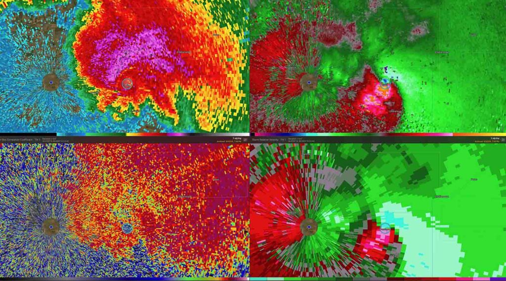
Velocity couplets on the right depict the rotating winds of two tornadoes that touched down in Oklahoma on April 30, 2024, and swirled around each other. One of the tornadoes was spinning clockwise (cyclonic), and the other was spinning counterclockwise (anitcyclonic). (RadarScope)
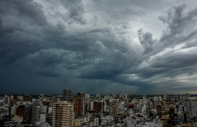
Nature has an uncanny ability to surprise us, often showcasing its power and beauty in the most unexpected ways. Recently, the skies above Oklahoma provided a breathtaking display of atmospheric ballet, as cyclonic and anticyclonic tornadoes engaged in a mesmerizing dance, swirling around each other in a stunning example of the Fujiwhara effect.
Understanding the Fujiwhara effect
The Fujiwhara effect, named after Japanese meteorologist Sakuhei Fujiwhara, occurs when two cyclonic vortices — such as tornadoes or hurricanes — come close enough to each other, causing them to rotate about a common midpoint. This interaction can result in a variety of outcomes, including the merging of the two storms into a single, larger system or the rotation of the storms around each other before eventually separating.
This rare phenomenon unfolded in Oklahoma, a US state known for its turbulent weather patterns and frequent tornado activity. On the night of April 30th, 2024, residents watched in awe as a pair of tornadoes, one spinning counterclockwise (cyclonic) and the other clockwise (anticyclonic), approached each other.
As they approached, their synchronized movements caused them to orbit each other, creating a spectacle that captivated both onlookers and meteorologists.
“The more data I look at the wilder this storm gets. Volumetric data shows a vortex hole from the ground up into the mesocycle [sic]. Centrifuging debris and hydrometeors away from the center of the circulation,” WCNC Charolette’s Chief Meteorologist Brad Panovich explained on X as he was immersed in studying the scenario. His analysis offered a glimpse into the complexity of the storm system.
Unraveling nature’s complexity
The swirling dance of the cyclonic-anticyclonic tornado duo defied conventional understanding, challenging scientists to unravel the intricate dynamics at play. While tornadoes typically repel each other due to their opposing rotational forces, the Fujiwhara effect brings them together in a rare embrace.
What causes this unusual phenomenon? The answer lies in the complex interplay of atmospheric conditions, including wind shear, pressure gradients, and the Coriolis effect, a force caused by the Earth’s rotation. When these factors align in just the right way, tornadoes become locked in a gravitational tango, defying the chaos of their destructive power.
From late April 2024 into early May, severe weather broke out for eight consecutive days across the central US. Intense thunderstorms spawned tornadoes and damaging winds. Officials have confirmed more than 100 tornadoes during a deadly stretch of severe weather that began Thursday April 25th and ended Monday April 29th. The strongest confirmed tornado was an EF4 that devastated Marietta, Oklahoma. Storm surveys are still being conducted by the local National Weather Service offices in the area.
The pattern of severe weather was attributed to a combination of factors including atmospheric instability, strong wind shear, and the presence of a potent storm system moving across the region. The resulting tornadoes and storms caused significant impacts, including property damage, power outages, and sadly, loss of life.
The Fujiwhara effect provides a compelling example of the intricate dynamics of storm systems and the interconnectedness of weather phenomena. Studying this case not only enhances our understanding of atmospheric science and mesoscale meteorology but it also helps improve weather forecasting and preparedness efforts in regions prone to severe weather events.
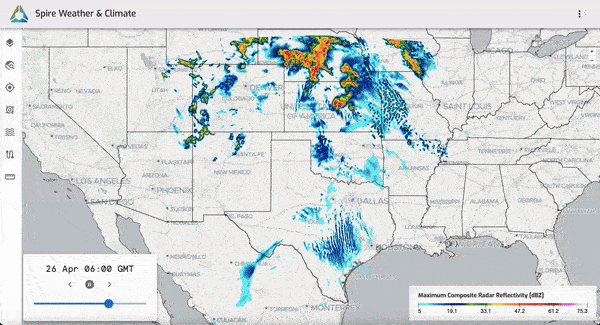
An animation of Spire’s High-Resolution Weather Model captured on Monday, April 22, depicts the predicted composite radar reflectivity for April 26-27, 2024, showing severe storms erupting across the Great Plains.
Enhancing weather preparedness
Events like the cyclonic-anticyclonic tornado tango serve as stark reminders of nature’s power and complexity, and the need for awareness and preparedness in the face of severe weather dangers. At Spire Global, our Weather Risk Communication Team is hard at work, 24/7 to bring situations such as this to light. Our team of expert meteorologists helps businesses prepare for and understand weather risks, empowering businesses to protect their people and assets during extreme weather events.
Additionally, Spire’s High-Resolution Weather Model, enhanced by satellite data that fills weather observation gaps worldwide, plays a vital role in improving forecast accuracy and preparedness. With precision up to 1-km resolution, our weather predictions extend out six days with detailed weather forecasts for every hour, providing ample lead time for businesses to mitigate weather risks. By leveraging cutting-edge technology and data-driven insights, we can better anticipate and respond to severe weather threats, minimizing their impact on lives and livelihoods.