The Analytical Moose: Harnessing weather data to enhance wildfire awareness
 Written by
Sharmain Zain
Content Manager at Spire Weather
“We live in a period where wildfires go from 10,000 acres to 1 million acres without warning. The speed at which these fires are spreading nowadays just makes it all the more difficult to evacuate people and combat it. I have lived through these fires and that’s why it’s important to me that I am able to build something that can notify residents in time.”
Rachel Brady
Founder, The Analytical Moose
Wildfires average 7 million acres of burnt land annually
The Analytical Moose provides GIS consulting services and drone imagery to customers from Wyoming to California. The past twenty years have seen an average of 7 million acres of land burning annually due to wildfires.
The Analytical Moose™ is the brainchild of Rachel’s vision for greater predictability around wildfires. To this end, her company, which provides GIS consulting services and drone imagery to its customers, is releasing a mobile wildfire notification application, Wildfire Aware™ this month (November 2022). The application will allow users to monitor locations near areas of interest and provide timely notification of fires that start. Serving the Western United States from Wyoming to California.
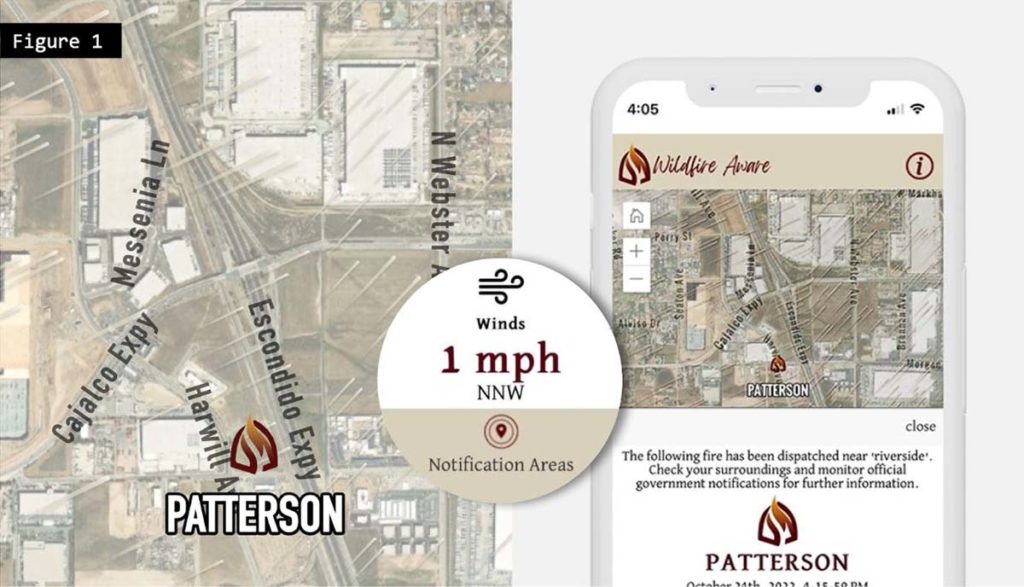
The figure above highlights a newly formed wildfire where the boundary is either unknown or so small that an individual point is used to represent the current location, while Spire current weather conditions are overlaid onto the map to give an indication of which direction the fire may spread. Further down the page, the application provides the user with additional weather information that contributes to the volatility of a wildfire.
Wildfires can either crackle and hiss out quickly or can extend their damages within a heartbeat to thousands of acres of land. When uncontrolled, the destruction and chaos occurs within mere hours. However, three variables influence the severity and movement of the wildfire: geography, weather and fuel.
The chemical composition, moisture levels and density will define the speed, spread and temperature of such a conflagration. If the land has low moisture levels and is dry in nature, then it will burn faster as there’s no water to fight the fire’s heat. For example, grass burns quicker and doesn’t create as much heat as trees and other similar fuel sources. A detailed understanding of weather parameters such as humidity, wind and temperature will help to model the wildfire’s path. Under windy conditions, wildfires will obtain additional oxygen and flare across the earthen floor at an accelerated rate.
Fueled mission to be a fire expert and GIS specialist
Rachael, the co-founder of the Analytical Moose, has personally lived through multiple wildfire events in Northern California (Bully, Carr, Zogg, etc.) whereby she has had to rush to get her friends and family out of the way of the fast moving fire. As a former member of the California Department of Forestry and Fire Protection, Rachael spent six years as a dispatcher. She was responsible for resource allocation during emergencies and maintained the supporting GIS database, followed by an additional seven years as a Research Data Specialist at CAL FIRE’s regional office.
Rachael fulfilled many roles in the CAL FIRE Northern Region office. She helped manage the database where CAL FIRE tracked all fuel reduction projects. She assisted with serial arson investigations, even winning the USGIF Government Achievement Award for her work. When fire activity was heavy in California, she would routinely provide GIS support for airspace coordination and regional coordination. Rachael is also an Infrared Interrupter and would quickly map fires based on nighttime flights by specialized aircraft, in 2018 she provided the first fire perimeter of the Camp Fire and had the first look at the widespread devastation from the air.
A collaborative effort between organizations like AM and Spire, with strong governmental support, offers a sustainable solution to this ongoing problem. A small fire, whether unintentional or created on purpose, when pushed by strong winds, is what essentially creates the need for real time, technology enabled tracking of weather and wildfires alike. The cumulative data will make or break any efforts put forward to mitigate future fire events.