In a Challenging Year, We Stayed Focused on Customers
in 2020 we grew our constellation, increased our output, launched new features and stayed focused on our customers.
2020 tested all of us. No matter what industry you are in and no matter where you are in the world, we all shared one common experience, that the year was not going to go as we planned. In this final month of the year, we are celebrating our relationships, our health, and our ability to adapt to extraordinary circumstances.
We Grew our Constellation
Our satellite constellation grew to more than 100+ satellites in orbit which means our AIS capabilities will continue to improve into 2021. We deployed two satellites from the International Space Station (ISS) on November 5th and launched four satellites on India’s PSLV on November 7th.

Spire’s LEMUR satellite – shot by the ISS November 2020
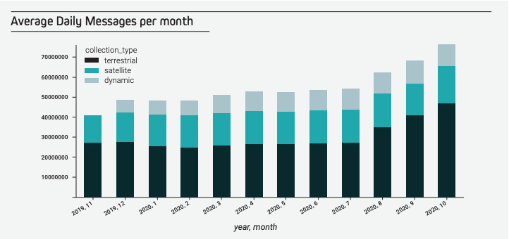
The Spire payload team configured our newest satellite AIS receiver to download all 27 types of AIS messages for the first time. As a result of these launches our satellite data capabilities have also increased and now we deliver more than +240K unique MMSIs, +70M daily Messages (Terrestrial, Satellite and Enhanced Satellite), and +54K unique IMOs.

Enhanced Satellite AIS continues to evolve as we now offer archived data and live data in both our API and TCP delivered with our satellite AIS data as part of a monthly subscription. Enhanced Satellite AIS provides exceptional coverage in high traffic zones, busy ports, and shipping lanes. The coverage is collected globally and reports ship positions every six minutes.
Weather and Analytics are the Future
Even with all of the disruptions 2020 delivered, the maritime industry remained focused on understanding how to leverage weather forecasts. Weather data, wave height, ocean currents, and wind data proved useful when looking at cost saving factors. Weather data is a key element in developing e-navigation, for storm tracking, and port weather predictions. Weather forecasts not only enhance your applications with improved transparency, but they can also be applied to advanced analytic solutions resulting in better fuel consumption and reduced costs. Your weather data should be easy to use, improve the accuracy of your analytics, and continuously innovate to stay ahead of the competition.
We published a handbook including applicable templates and an evaluation framework that we share with our customers to support their evaluation of forecast quality and provider offerings.
At Spire Maritime, we created a maritime specific bundle, a wave bundle and storms bundle, to make sure you receive only the variables you need to ensure your weather forecast is enhancing and supporting your solutions. If your use-case is specific, we can provide more than 70 unique data variables and build a custom bundle delivered through our easy-to-use APIs.
New Tools
Our AIS data is being used in amazing ways and we are proud of the power this data provides many of our customers. Beyond ship tracking, many of our customers use our AIS data in unique ways to accomplish their goals.
Read how Global Fishing Watch created a new tool using Spire Global’s AIS data to shine a light on transshipment—a critical process of high seas fishing that is vulnerable to exploitation. The publicly accessible carrier vessel portal records and visualizes all encounters at sea where transshipment could take place. It isn’t just useful for detecting suspicious activity; it’s also a powerful tool for recognizing compliance and a valuable resource for studying transshipment.
We also created Predict AI Route as part of our premium features to provide our customers with ETA and port arrival predictions via an easy to use API visualized geographically per region or dry bulk port. These accurate ETA predictions help you build improved operations as you reduce the costs associated with shipping and port operations. Read our data story comparing AIS ETA’s and Predict-AI ETA’s.
The Trusted Source Open Ocean Weather Data
Spire Maritime Weather helps you reduce risk and maximize profits with advanced ocean weather forecasts. Spire Maritime Weather helps you analyze and predict shipping weather, vessel performance, and port forecasts. With higher resolution over oceans (our data is collected from the ground up to 120 km) providing unique, medium-range forecast capabilities in open oceans. Our modern APIs are designed for ease of use and integration into existing workflows and since we frequently launch satellites, we collect more radio occultations and continuously improve weather forecasts over oceans.
“Spire’s radio occultation provides more observations over the oceans, which then provides better initial conditions for models”
Read more about our work with PredictWind
Share on Facebook Share on Twitter Share on LinkedIn
Reach out to us.
We are always looking to partner with startups and established companies to solve new challenges.
 Written by
 Jack Katzfey


