Mitigating marine shipping risk with big tech tools
 Written by
Emmanuel Rosetti
Maritime Sales Engineer, Spire Global
For most people working in the shipping industry, making the right decision within a specific context drives decision-making.
Finding the right hauler for your product. Scheduling your stevedores to ensure ships can get in and out of port. Calculating the best course to avoid dirty weather while minimizing transit time.
But for some, taking a step back, looking at the big picture, and providing better information for making those in-context calls is the driving force. Providing ways to better manage marine shipping risk can minimize vulnerabilities while maximizing possibilities for the sector.
I was recently part of the webinar “Applying AIS Data to Marine Shipping Risk.” Hosted by Meghan Mathieson of Clear Seas, with Rob Marshy of Global Spatial Technology Solutions (GSTS) also presenting, we provided an in-depth overview of how to use the best tech from the Big Data era to build a better maritime industry.
The event was under the auspices of the Canadian Marine Shipping Risk Forum, which was initiated by the Marine Environmental Observation, Prediction, and Response Network (MEOPAR) and Clear Seas, with support from exactEarth. The webinar included a knowledgeable audience that followed up with very interesting comments, including some questions on exactTrax, usage of the AIS data, geofencing capabilities, and coverage of satellite AIS.
A hub of information
Having the Clear Seas Centre for Responsible Marine Shipping’s director of strategy and innovation host this webinar was a natural fit. This non-profit, founded in 2014, is dedicated to making the Canadian marine shipping industry safer and more sustainable. It acts as a clearinghouse for government, businesses, environmental organizations, and Indigenous coastal communities to build a base of accurate, impartial information. By initiating and interpreting research, analyzing policies, and identifying best practices—with a significant commitment to including Indigenous stakeholders—the Centre is a go-to source moving forward, especially as Arctic waters are open to maritime transport.
Applying AIS Data to marine shipping risk
In the first section of the webinar, I lay out how Spire AIS can enhance situational awareness for the industry, especially concerning better stewardship of the environment as ships traverse maritime ecosystems. This runs the gamut of tackling illegal fishing, better mitigating the risks of oil and gas shipments, reducing emissions, and bettering environmental practices. Given how quickly shipping interests are moving into northern waters, these are profound issues of concern for Canada.
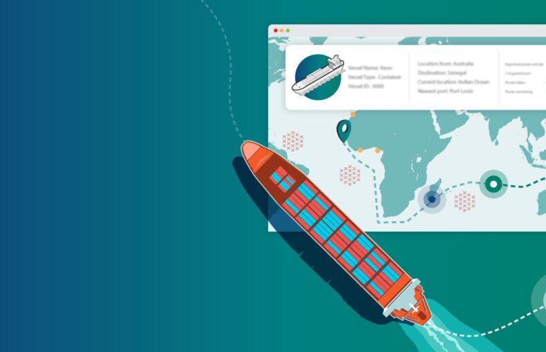
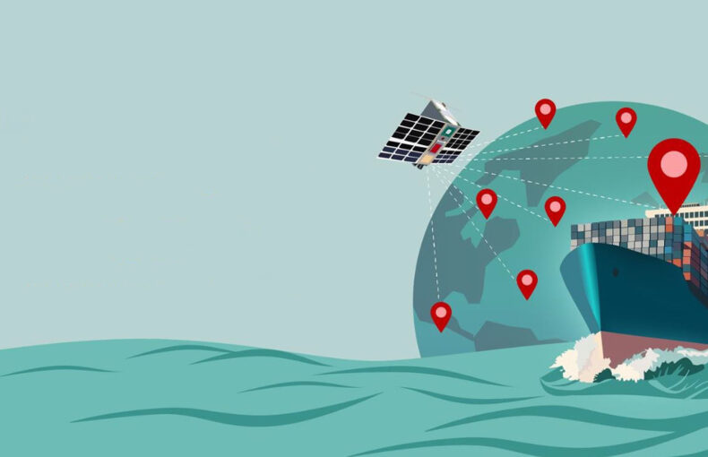
I take some time to explain how Spire’s fleet of over 165 satellites receive automatic identification system (AIS) tracking information from ships and, on the backend, how we can package that data to solve a wide range of business, regulatory, and planning challenges. With our network receiving over 290 million AIS and 280,000 maritime mobile service identity (MMSI) messages per day, we have a lot of data to work with.
What Spire provides is complete visibility of vessel traffic over the entire globe, which can greatly enhance operational effectiveness and regularity strategies. For example, Global Fishing Watch has partnered with Spire to better track vessels that may be participating in illegal, unreported, and unregulated (IUU) fishing. Identifying, in real-time, ships that are piggybacking on legitimate fishing vessels, monitoring marine protected areas where fishing is restricted, and verifying (or not) the position reports of ships when they return to port are all services that Spire AIS is providing. Similar granular data is being used in a wide range of ways to better protect ecosystems, all of which I go into detail about in the webinar.
Overall, it was a really excellent opportunity to present what AIS is and how it can be used in a different context to address multiple maritime risk.
On a personal note, it was a pleasure to be able to present this to some former colleagues from the Federal Government of Canada, with multiple members from Transport Canada, the Department of Fisheries and Oceans Canada, and the Canadian Coast Guard.
“Spire’s presentation demonstrated several ways satellite AIS data is being applied to monitor vessel traffic in real time. When this data is viewed through analytical platforms such as GSTS’s OCIANA, we can see an enhanced marine situational awareness and reduce risks associated with commercial marine shipping.”
Meghan Mathieson
Co-lead of the Canadian Marine Shipping Risk Forum and Director of Strategy & Innovation for Clear Seas Centre for Responsible Marine Shipping
Share on Facebook Share on Twitter Share on LinkedIn
AI-enhanced maritime domain awareness
 In the second section, Rob Marshy of Global Spatial Technology Solutions (GSTS) walks us through how data can be used to recognize overarching patterns. GSTS is a Canadian company that uses artificial intelligence (AI) and Big Data analytics to provide decision-making support for the maritime, energy, and security sectors. The company specializes in predictive technologies that empower sustainable solutions.
While my half of the webinar concentrates, though not exclusively, on how Spire collects its data and how it is used in specific contexts, Marshy focuses on the OCIANA Maritime AI Platform, which integrates multiple streaming data sources to extract patterns. These are analyzed to provide domain awareness to support a range of coordinated policies and procedures.
“We’re not a satellite provider whatsoever. We’re not a data provider; we actually ingest (buy and purchase) satellite data—including the Spire dataset—and apply the advanced analytics and deliver as a capability to the user community,” Marshy explains. “So we really focus on that. OCIANA is data agnostic and it’s ingesting about roughly 10-plus data sources at various stages, either real-time or periodically. All of this data, whether it’s regulatory static data or real-time data or meteorological data, is all used to extract patterns. And that is used—that same data and those same patterns—are used for both risk management and vessel management. So it’s kind of a dual application.”
Rob goes on to explain the configurable modules in which OCIANA’s insights are shared with end-users. The end game is to empower evolving solutions “that can match the evolving risk using evolving data.”
Harnessing tech to deal with approaching reality
The webinar delivers on its fascinating topic, aspects of which are both the mechanism for collecting an amazing amount of granular data about a wide range of vessels and how that data can be algorithmically digested to create predictive models.
With so many pressures facing so many maritime areas—from reductions in fishing stocks to container ships moving into Arctic waters to changes in weather patterns—now is a time for every tool to be used to better protect the world’s oceans. The powerful ways that data can now be amassed, and better understood with AI tools, is really an exciting area of study that organizations like Clear Seas can share to minimize the risks, and posed by, the shipping industry.
Want to know more about how Big Tech is being harnessed for the maritime world? If so, please check out the “Applying AIS Data to Marine Shipping Risk” webinar.