ShipView: An environmental protection tool to fight oil pollution
 Written by
Leah Bushe
Customer Success Specialist, Spire Maritime
Oil pollution wreaking devastation in the world’s oceans has a long, unfortunate history.
Prior to widespread offshore drilling, the menace was strictly from ships carrying petroleum products. Today that particular risk still exists, in addition to accidents and malfunctions at offshore drilling platforms or pipelines.
Several factors—including the rise of Southern California as a major metropolitan area, the extensive growth of ports in the greater Los Angeles area, and the discovery of the Carpinteria Offshore Oil Field in the Santa Barbara Channel in 1964—have made the coastline of California rich in oil spills.
One of the first major ocean oil spills, totaling 600 barrels, occurred off Ventura County Beach in 1929, soon after the first oil leases in the area were granted. Forty years later, the infamous 1969 Santa Barbara spill occurred, dumping approximately 100,000 barrels after a drill blow-out and quickly inspiring the first Earth Day and the broader environmental movement. That spill still ranks as the United States’ third worst, after another drilling-related accident (Deepwater Horizon in 2010) and the wreck of the Exxon Valdez tanker in 1989.
Even minor oil spills, including leaks from ships, can wreak havoc on sensitive marine ecosystems. Spills near popular beaches force closures. Inland waterway accidents can put sources of drinking water at risk. Consequently, steadily improving the safety of oil industry infrastructure and expanding the tools with which to monitor the world’s waters are vital.
SkyTruth: Using tools to protect
One entity dedicated to keeping a watchful, protective eye out for the world’s waterways is SkyTruth. This nonprofit environmental organization harnesses some of the world’s most modern and cutting-edge tech—including Spire’s ShipView application—to, as explained on its website: “(1) provide fact-based information and analyses to conservationists and the public for free, and (2) share the tools and technologies that enable such analyses with others, so they can monitor the places they care about on their own and hold industries and governments accountable.”
Since its founding in 2000 by John Amos—then a remote sensing expert who was using satellite imagery in the resource-extraction industry—SkyTruth quickly became a go-to source for environmental watchdogs who were used to being outgunned by the tech that large corporations had in the field.
Much of SkyTruth’s early growth was due to its rapid response to the Deepwater Horizon spill, which BP and the Obama administration prevaricated about in real-time. According to a 2013 Washington Post article:
“Amos is, by many accounts, reshaping the postmodern environmental movement. He is among the first, if not the only, scientist to take the staggering array of satellite data that have accumulated over 40 years, turn it into maps with overlays of radar or aerial flyovers, then fan it out to environmental agencies, conservation nonprofit groups and grass-roots activists. This arms the little guys with the best data they’ve ever had to challenge oil, gas, mining and fishing corporations over how they’re changing the planet.
His satellite analysis of the gulf oil spill in 2010, posted on SkyTruth’s Web site, almost single-handedly forced BP and the U.S. government to acknowledge that the spill was far worse than either was saying.”
Share on Facebook Share on Twitter Share on LinkedIn
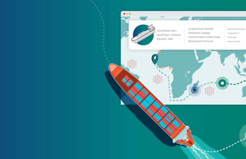
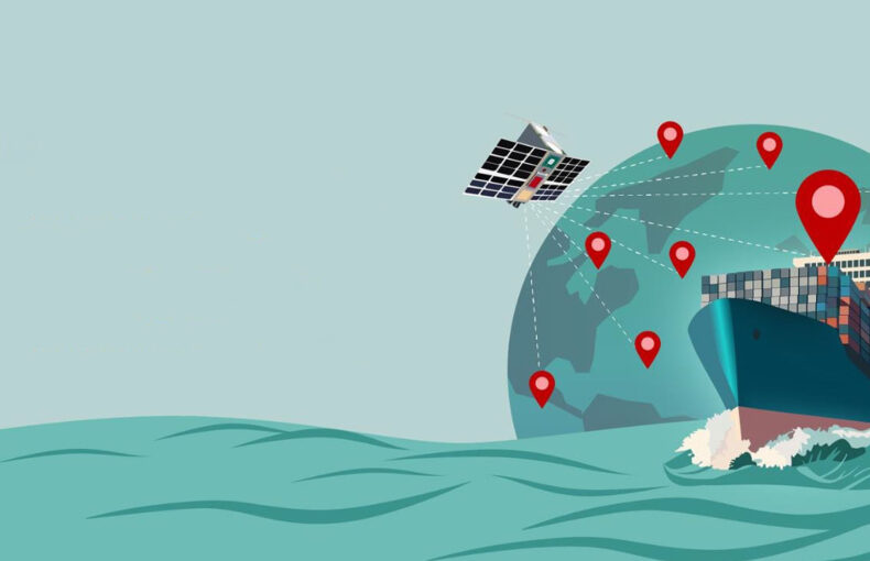
SkyTruth has been using ShipView for over a decade. By combining satellite and terrestrial AIS that live tracks all AIS-enabled vessels, real-time access to a vessel’s position, current voyage status, reported destination, announced ETA, and other info can be quickly retrieved. Such capabilities are especially important during an active oil spill or other accident.
The integration of ShipView into SkyTruth’s work is perhaps best illustrated when SkyTruth sprang into action after yet another accident on the California coast, the October 2021
Huntington Beach oil spill. As outlined on its “The Huntington Beach Oil Spill: How SkyTruth Investigates Environmental Incidents” webpage, SkyTruth went through a series of steps to zero in on what was happening immediately after oil was discovered on the open water. A vital part of the process was:
“… to find out which vessels had been in the area at the time and to track their movements during the time of the spill. To do this, we placed map markers on all the nearby vessels to find out their exact latitude/longitude coordinates. Once we had this information, we used a commercial product called exactEarth ShipView™ to identify the vessels by name and track their movements.
After identifying the vessels in ShipView™, we exported each ship’s tracks and added them to the Alerts map using the Add Layers tool … In each case, we added oil slick outlines, arrows, and text to the map to show what we thought we were seeing.
Finally, we saved our work as a public map so it could be shared with news media, on Facebook and Twitter, and with reporters.”
Share on Facebook Share on Twitter Share on LinkedIn
Eventually, it was discovered that the spill was caused by a leak in an offshore Amplify Energy oil pipeline. The cause of the catastrophic failure was not apparent at the time, but as explained in a Los Angeles Times article a few days later:
“The offshore waters along the Orange and Los Angeles county coasts are teeming with cargo ships, creating a traffic jam into the ports of Los Angeles and Long Beach that has kept dozens of vessels idling as they wait to get in.
Did an anchor from one of those ships strike an underwater oil pipe, causing a massive spill of tens of thousands of gallons of crude?
That possibility is what the U.S. Coast Guard is now investigating as it tries to determine what led to the spillage of up to 144,000 gallons of oil that began flowing into the ocean Friday …”
Share on Facebook Share on Twitter Share on LinkedIn
Nearly six months later, in March of 2022, the possibility that a vessel had invertedly damaged a piece of oil production infrastructure, with dire consequences, was still at the core of the accident investigation.
Needless to say, in such a complex case, having the kind of historic AIS data that ShipView makes available is invaluable to researchers and investigators when attempting to determine when the original damage occurred.
SkyTruth has built a stellar reputation that spans a number of environmental areas of concern, including not just offshore oil spills but hydraulic fracturing, mountaintop removal, illegal fishing, and habitat monitoring.
ShipView: An observational Swiss Army knife
The ShipView application is one tool being utilized in the fishing industry, including smaller artisanal fisheries, increasing safety for both those working in the industry and preserving the precious natural resources on which it depends.
As a preventive tool, ShipView can send alerts based on set fields like vessel statuses or positions, identify specific vessels or ship types, and geo-target areas of interest. Such notifications can be delivered by email or via the internal ShipView alert system.
A rich information system
ShipView allows for segmenting vessels by type, subtype, cargo, and vessel characteristics, including access to data about capacity, size, ownership, structural specs, and high-quality photos. Information can be organized into specific periods with date/time ranges and multi-year lookbacks, including integrated timestamps on historical track layers for easy analysis.
These capabilities are especially valuable in the monitoring of ship movements in and around protected or environmentally sensitive sea areas, such as:
- Areas to be avoided: Hazardous areas like oil and natural gas extraction zones and wind farms in which accidents can be particularly dangerous.
- Marine Protected Areas (MPA): Areas recognized and defined by national, regional, or international entities for their particular habitat and/or historical importance and in which pollution can damage defined ecosystems.
- Particularly Sensitive Sea Areas (PSSA): The dozen-plus maritime regions—including Australia’s Great Barrier Reef, the Florida Keys, the Strait of Bonifacio between Corsica and Sardinia, and Tubbataha Reefs Natural Park in the Philippines—all threatened by international maritime activities.
ShipView is the perfect instrument for monitoring vessels in such areas—and any other for that matter—both to prevent accidents or to collect information after a devastating event such as an oil spill.
ShipView can be used to track ships and better ensure they stick to their pre-defined courses near sensitive areas. During after-the-fact investigations, it can be used to help piece together the timeline, and create reports on vessels that may have entered protected areas without notifying authorities.
And with Spire’s decade-plus vault of historical AIS data, better routing decisions can be made by studying maritime traffic patterns over the long term. This can lead to route refinements and changes that ensure normal traffic has the least impact on protected zones. This is just one aspect of the broader field of maritime optimization where big AIS data is being put to use.
Oil spills are still with us
Though there hasn’t been a mega spill for years, the escape of petroleum and natural gas products into maritime ecosystems has certainly not been eliminated. But AIS tools are now routinely used in rapid response scenarios for assessment, which is crucial in quickly setting up effective mitigation efforts. And, developing case studies can make future operations safer. A recent addition to the toolkit quickly ascertains facts to share via blog posts, social media, and media blasts, getting crucial information to the public in a timelier manner.
Empowering activism
Expanding what is possible in the field of environment protection is just one of the powerful aspects of ShipView, which harnesses AIS data in a way that can be used by subject-matter experts ranging from marine researchers to industry managers. This includes John Amos and the SkyTruth team, who for the last decade have been pursuing data-driven activism, as Amos explained in the 2013 Washington Post piece:
“We want to play Tom Sawyer, to get the whitewash and the fence, and then get people to do the rest of the work, looking at their own patch of the planet. Really, what I’d like, the goal here, is for ‘SkyTruthing,’ to be an activity, a verb, like ‘Googling.’ As in ‘I Googled this’ or ‘I SkyTruthed that.’”
Share on Facebook Share on Twitter Share on LinkedIn
ShipView provides actionable and specific data, empowering everyone dedicated to protecting our oceans and natural resources from pollution and environmental damage, and enhancing the safety of those working in maritime-related jobs.