AIS Data: The foundation of Maritime Analytics
 Written by
Lasse Urth
EMEA Sales Director, Spire
The concept of gathering detailed information about the complexities of seafaring in order to improve future decision-making is as old as the art of sailing.
Ancient Polynesians, beginning around 1000 BCE, began exploring the wide expanse of the Pacific Ocean and eventually populated nearly every island in it. They used a range of information gathering and communication techniques, including oral traditions embedded with navigational instructions. Likewise the Greeks, Vikings, Basque, and many other maritime cultures.
Today, electronics and databases provide the information and historical knowledge necessary to sail the world’s oceans far more powerfully and efficiently—though with a little less poetic beauty. It’s doubtful anyone will turn a dataset into The Odyssey.
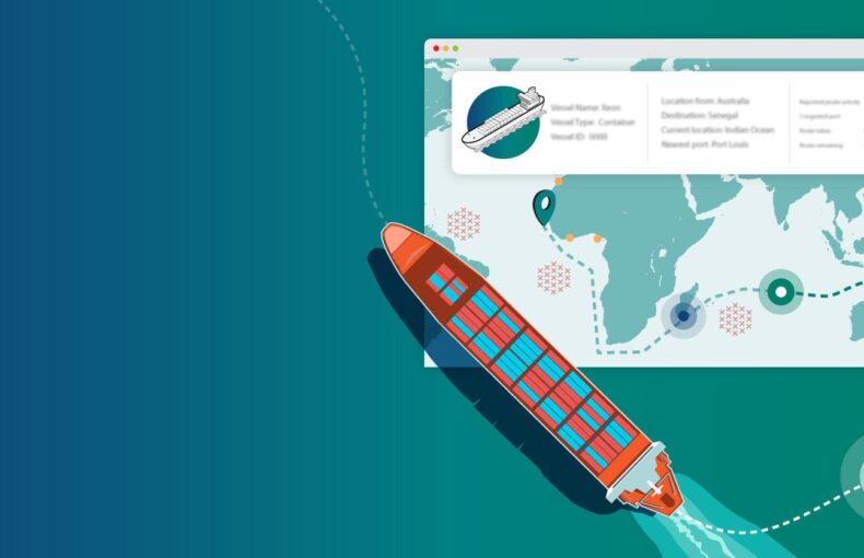
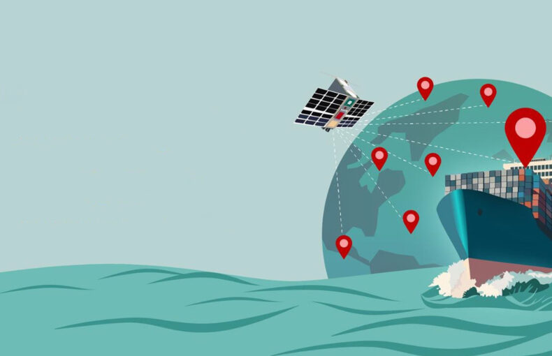
The modern automatic identification system (AIS) connects the world’s fleet of large ocean-going ships to satellite networks that cover the globe from orbit. It is the bedrock of modern maritime analytics that—like the craft practiced by ancient mariners—is the art of gathering and circulating information that anyone facing the challenge of sailing the seven seas can use to improve their odds.
What is Maritime Analytics?
As the MarineTraffic website puts it:
“Maritime analytics is the systematic analysis of data to provide stakeholders in the maritime ecosystem with insights and tools to help them make better decisions for their work lives or businesses. Practically put, it is the process of collecting and analysing data to produce and disseminate meaningful information and actionable intelligence around shipping-related activities. At any scale and for countless of applicable use cases.”
It is used by a wide variety of industry stakeholders, including shippers, cargo owners, port managers, and many organizations that serve the shipping industry or work to mitigate its environmental impact. The inherent power of maritime analytics is in providing transparency, predictableness, and information gathering of the highest order.
Again, not a new concept
As mentioned, this is not a new realm of human endeavor, though AIS is helping build its most modern iteration. From oral storytelling to meticulous logbooks, observation and data sharing have long been part of life on the seas.
For example, since its earliest days, the Royal Navy required a ship’s captain, lieutenant, and master to all keep separate, detailed logs about crew activities and weather conditions each day during a voyage. These were handed over at journey’s end. This wealth of detailed information was used in many ways and represented a huge investment in intelligence gathering. Today, these historic records are being put to use to better understand climate change, as they represent a deep database of historic weather patterns around much of the globe.
Likewise, modern data analytics are being used to examine the historic shipping and trade patterns that shaped the modern maritime industry. As stated in a recent article in Research in Transportation Business & Management: “It seems that big data of the past still can inspire future explorations of our historical transport networks on the world’s oceans.” The research paper in question—”Big Data of the Past: Analysis of Historical Freight Shipping Corridor Data in the Period 1662–1855″—was based in large part on information collected by the Climatological Database for the World’s Oceans (CLIWOC), an EU funded project that converted British, Dutch, French, and Spanish logbook from 1750 to 1850 into a computerized database.
AIS: A versatile and powerful tool
Though these Age of Sail archives are vitally important, both as historical documents and as the most precise records of weather information from the period, they were far from perfect. Between records lost to shipwrecks, insufficient land-based storage of logbooks, and the inherent likelihood of errors when measurements and observations were taken on ships rolling on the open sea with only candles and lamps as illumination after dark, the fact is that historic maritime records were far from fully dependable and all-encompassing.
But today, much of the information captured with pen and paper by fatigued members of a ship’s crew is now gathered automatically via AIS. The course, speed, weather conditions, and other important data are relayed in regular bursts to satellites that, in turn, communicate with computer servers to create an ever-widening, always-updated dataset covering the activities of all the larger ocean-going ships the world over.
As this information session, part of the 2021 Maritime Analytics Conference (which included Spire’s Head of Data Operations Mark Deverill) explores in detail, the breadth of AIS usage in the shipping industry has expanded rapidly over the past two decades. As MarineTraffic’s Head of Data Stellios Stratidakis explains:
“Now, as the custom networks of AIS-specific stations have been growing together with the capabilities, additional applications of the protocol have been made possible. These factors combined with the rise of technology and digitalization has really enabled us to move from data, to information, to intelligence. Now, from a services provider point of view, in the early days it was all about putting dots on maps to showcase where vessels are. But the combination of the factors mentioned before I think enabled faster processing and archiving. And you know, as with many things in life, knowledge of the past helps with understanding and inferring what might happen in the future.”
It took centuries for handwritten logbooks to be digitized and thus made ready to contribute to modern data analytics, but AIS has—after being developed primarily as a safety feature to help avoid ship collisions—made the same leap in just a few decades. Today, it has quickly become the foundation for much maritime analytics, in large part because the amount of information gathered is so thorough and far-reaching.
As Stratidakis put it: “Nowadays, about 1 billion AIS messages get processed on a daily basis. And this data is continuously fused with other datasets and information sources to generate additional value.”
Full-ocean visibility
The most obvious aspect of AIS’s power is the full-ocean visibility it provides a multitude of stakeholders in real-time and the ongoing expansion of historical AIS data that this creates. Unlike observational data stored on ships that were not readily accessible until a port call was made and was further processed by clerks, or even in later eras when information was shared via radio and further distributed, the nearly instantaneous uplinking of granular data into readily accessible databases is now profound.
This provides a 24-7 bird’s-eye view of the international maritime industry—and thus much of the world’s supply chain—that is subject to almost immediate analysis. This data has become a profound value-added product in the marketplace.
Combining AIS and advanced weather forecasting

One area where the rapid expansion of AIS-data capabilities is being most profoundly felt is in the cross-pollination of weather forecasting with maritime data analytics. This kind of advanced predictive analytics can not only significantly impact safety but also be used to improve fuel efficiency, lessen emissions, and optimize vessel payloads.
The key to this leap forward is the speed with which AIS and weather information can now be transmitted to and from ships all around the world. Coupled with machine learning capabilities, real-time maritime analytics can be the basis of creating dynamic route guidance for ships, optimizing short- and medium-term route planning, and reacting quickly to potential foul-weather disasters, all of which will reduce insurance outlays and improve profit margins.
A keen enforcement tool
Another area on which AIS is being focused is surveilling the high seas. One of the scourges of ocean conservation is illicit fishing vessels that work “off the radar” and deplete fish stocks in areas that have been overharvested. But recent advances in big data and the abundant amount of AIS information now being collected are helping to curtail such problems. Spire has worked with Global Fishing Watch (GFW) to expand the knowledge base of watchdog groups whose mission is to protect the world’s oceans.
https://www.shutterstock.com/image-photo/aerial-view-large-number-fishing-trawlers-1155376234
“Having the low-cost, global coverage that you get with the Spire satellite AIS completely transforms our ability to understand what’s going on out there,” explains Paul Woods, the chief innovation officer of GFW. “We also benefit from a dynamic environment where we can interact with the data and collaborate with Spire on how we are going to use it in an open way.”
In the same way, AIS-based maritime analytics can also be brought to bear on policing international sanctions. For example, Russian oil tankers are currently being followed via AIS to ensure that the West’s economic steps to counter the invasion of Ukraine are being observed.
Data Analytics: plugging in the information
As has been emphasized, AIS data collection has been growing during this century. What is new is the ever-expanding power of big data analytics and its increasing role in the maritime industry, which is playing catch-up to some other industries that were earlier adaptors of these new tools.
As outlined in the 2018 report Use of Big Data in the Maritime Industry that was commissioned by Trelleborg Marine Systems:
“Even though big data has significantly benefitted industries such as finance, media, telecom and healthcare, its uptake by the maritime industry has been slow. According to a report by Ericsson, the maritime industry lags behind other transport industries in terms of its use of information and communications technology. Only a handful of marine companies currently leverage big data.
There are several benefits that the industry can derive through the use of big data. The industry generates roughly 100-120 million data points every day, from different sources such as ports and vessel movements.
Companies can analyze these data points to identify efficiencies such as quicker routes or prefered ports. Ultimately resulting in an extra 5 to 10% increase in performance.”
There really are a myriad of ways that the rich datasets that AIS has and continues to build for maritime analytical applications will be used in the near future.
Working the bugs out in virtual reality
For example, the use of digital twins—which are virtual depictions of an asset that can be continually refreshed using real-time data—is becoming more common in the marine sector. This kind of simulation, using machine learning, can improve real-world decision-making and performance by modeling during the design phase and then performance optimization after deployment, when advanced diagnostics can be run on the digital twin far faster than it could be implemented piecemeal on the actual asset.
This same technology is also being adapted to the supply chain. The key difference between a digital twin and a simple computer simulation is that the latter predicts what will happen based on information from the past, while a digital twin—thanks to rich real-time data inputs from sources like AIS—shows what is happening in real-time and allows for the testing of various solutions using the most current data.
A wider, faster web of information
Maritime analytics has always been based on the careful collection of data and then the warehousing of that information in a central location. What is different today is that the information is now collected over a much wider area and in far more detail, while the “central location” is now the cloud-based Internet. Instead of having to travel to the United Kingdom’s National Archives—on the River Thames in Richmond outside London—to peruse the logbooks of journeys long since completed (though these days you can peruse some online), information about the world’s ocean-going vessels is available almost instantaneously to those plugged into the AIS matrix.
This brings a far greater and more complex wealth of datasets into play. Coupled with the still-emerging capabilities of machine learning and artificial intelligence, maritime analytics has attained a much higher plane. Instead of depending on data from voyages of the past, today’s AIS provides real-time input about all the pieces moving on the world’s oceans.